|
|
|||||||||||||||||
| Point ID: 7870 | Downloads | Plots | Site Data | Code: 3339 |
|
|
|||||||||||||||||
| Download | |
|---|---|
| Site Descriptor Information | Site Time Series Data |
| Link to all available data | |
|
|
| View: | Statistics | Time Series |
| Units: | m3/s |
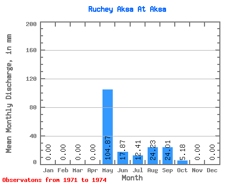
| Statistic | Jan | Feb | Mar | Apr | May | Jun | Jul | Aug | Sep | Oct | Nov | Dec | Annual |
|---|---|---|---|---|---|---|---|---|---|---|---|---|---|
| Mean | 0.00 | 0.00 | 0.00 | 0.00 | 104.89 | 17.87 | 12.43 | 24.20 | 24.01 | 5.18 | 0.00 | 0.00 | 172.42 |
| Standard Deviation | 0.00 | 0.00 | 0.00 | 0.00 | 54.72 | 13.29 | 21.46 | 19.52 | 10.69 | 4.38 | 0.00 | 0.00 | 100.97 |
| Min | 0.00 | 0.00 | 0.00 | 0.00 | 35.03 | 3.46 | 0.00 | 4.74 | 12.01 | 0.73 | 0.00 | 0.00 | 71.30 |
| Max | 0.00 | 0.00 | 0.00 | 0.00 | 148.86 | 29.66 | 37.22 | 43.78 | 32.49 | 9.49 | 0.00 | 0.00 | 273.25 |
| Coefficient of Variation | 0.52 | 0.74 | 1.73 | 0.81 | 0.45 | 0.84 | 0.59 |
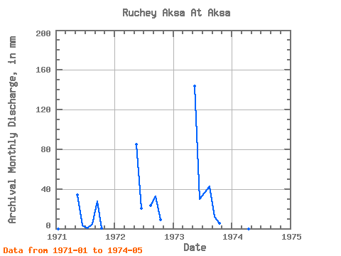
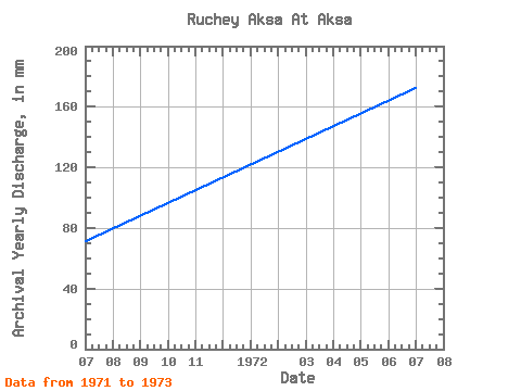
| Year | Jan | Feb | Mar | Apr | May | Jun | Jul | Aug | Sep | Oct | Nov | Dec | Annual | 1971 | 0.00 | 0.00 | 0.00 | 0.00 | 35.03 | 3.46 | 0.07 | 4.74 | 27.54 | 0.73 | 0.00 | 0.00 | 71.30 | 1972 | 0.00 | 0.00 | 0.00 | 0.00 | 87.56 | 20.48 | 0.00 | 24.08 | 32.49 | 9.49 | 0.00 | 0.00 | 172.71 | 1973 | 0.00 | 0.00 | 0.00 | 0.00 | 148.86 | 29.66 | 37.22 | 43.78 | 12.01 | 5.33 | 0.00 | 0.00 | 273.25 | 1974 | 0.00 | 0.00 | 0.00 | 0.00 | 148.13 |
|---|
 Return to R-Arctic Net Home Page