|
|
|||||||||||||||||
| Point ID: 7869 | Downloads | Plots | Site Data | Code: 3338 |
|
|
|||||||||||||||||
| Download | |
|---|---|
| Site Descriptor Information | Site Time Series Data |
| Link to all available data | |
|
|
| View: | Statistics | Time Series |
| Units: | m3/s |
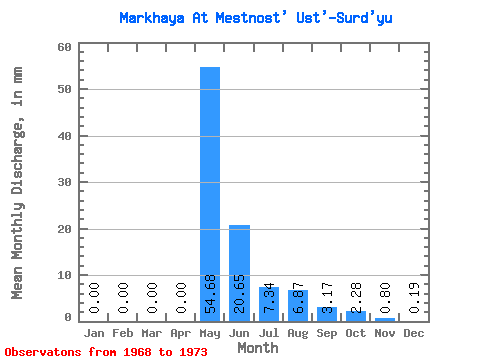
| Statistic | Jan | Feb | Mar | Apr | May | Jun | Jul | Aug | Sep | Oct | Nov | Dec | Annual |
|---|---|---|---|---|---|---|---|---|---|---|---|---|---|
| Mean | 0.00 | 0.00 | 0.00 | 0.00 | 54.67 | 20.65 | 7.34 | 6.87 | 3.17 | 2.28 | 0.80 | 0.20 | 98.39 |
| Standard Deviation | 0.00 | 0.00 | 0.00 | 0.00 | 25.87 | 12.60 | 7.26 | 12.40 | 2.87 | 1.96 | 1.10 | 0.23 | 58.45 |
| Min | 0.00 | 0.00 | 0.00 | 0.00 | 28.84 | 4.66 | 0.89 | 0.67 | 0.64 | 0.43 | 0.07 | 0.00 | 42.41 |
| Max | 0.00 | 0.00 | 0.00 | 0.01 | 96.13 | 42.68 | 16.18 | 28.99 | 6.92 | 4.66 | 2.42 | 0.47 | 173.22 |
| Coefficient of Variation | 2.24 | 0.47 | 0.61 | 0.99 | 1.81 | 0.90 | 0.86 | 1.37 | 1.21 | 0.59 |
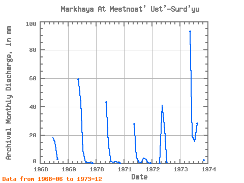
| Year | Jan | Feb | Mar | Apr | May | Jun | Jul | Aug | Sep | Oct | Nov | Dec | Annual | 1968 | 18.54 | 15.18 | 3.00 | 1969 | 0.00 | 0.00 | 0.00 | 0.00 | 61.19 | 42.68 | 9.54 | 0.93 | 0.64 | 0.43 | 0.07 | 0.00 | 114.82 | 1970 | 0.00 | 0.00 | 0.00 | 0.00 | 44.79 | 14.55 | 1.28 | 0.75 | 1.25 | 0.96 | 0.16 | 0.00 | 63.11 | 1971 | 0.00 | 0.00 | 0.00 | 0.00 | 28.84 | 4.66 | 0.89 | 0.67 | 3.88 | 3.07 | 0.56 | 0.31 | 42.41 | 1972 | 0.00 | 0.00 | 0.00 | 0.01 | 42.42 | 23.85 | 0.97 | 1973 | 0.00 | 0.00 | 0.00 | 0.00 | 96.13 | 19.64 | 16.18 | 28.99 | 6.92 | 4.66 | 2.42 | 0.47 | 173.22 |
|---|
 Return to R-Arctic Net Home Page