|
|
|||||||||||||||||
| Point ID: 7838 | Downloads | Plots | Site Data | Code: 3233 |
|
|
|||||||||||||||||
| Download | |
|---|---|
| Site Descriptor Information | Site Time Series Data |
| Link to all available data | |
|
|
| View: | Statistics | Time Series |
| Units: | m3/s |
| Statistic | Jan | Feb | Mar | Apr | May | Jun | Jul | Aug | Sep | Oct | Nov | Dec | Annual |
|---|---|---|---|---|---|---|---|---|---|---|---|---|---|
| Mean | 8.48 | 4.82 | 3.94 | 6.27 | 181.78 | 216.14 | 67.65 | 92.62 | 86.93 | 50.59 | 26.00 | 15.10 | 758.10 |
| Standard Deviation | 6.43 | 5.08 | 4.97 | 6.25 | 80.97 | 166.18 | 23.08 | 60.82 | 33.93 | 23.98 | 10.10 | 5.91 | 176.60 |
| Min | 0.00 | 0.00 | 0.00 | 0.00 | 31.51 | 36.04 | 33.65 | 36.52 | 26.34 | 18.62 | 8.32 | 2.65 | 429.52 |
| Max | 27.21 | 15.66 | 15.75 | 19.41 | 322.94 | 658.40 | 108.84 | 332.24 | 198.21 | 102.39 | 51.29 | 27.21 | 1127.24 |
| Coefficient of Variation | 0.76 | 1.05 | 1.26 | 1.00 | 0.45 | 0.77 | 0.34 | 0.66 | 0.39 | 0.47 | 0.39 | 0.39 | 0.23 |
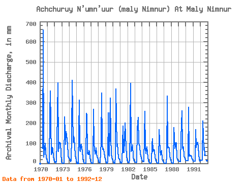
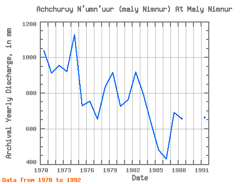
| Year | Jan | Feb | Mar | Apr | May | Jun | Jul | Aug | Sep | Oct | Nov | Dec | Annual | 1970 | 0.00 | 0.00 | 0.00 | 0.00 | 78.77 | 658.40 | 33.65 | 55.85 | 99.80 | 55.85 | 27.72 | 22.20 | 1039.34 | 1971 | 12.89 | 0.72 | 0.14 | 0.28 | 252.05 | 358.31 | 44.40 | 49.41 | 79.70 | 70.17 | 33.96 | 10.03 | 911.15 | 1972 | 6.59 | 9.13 | 1.86 | 13.86 | 110.99 | 397.81 | 60.86 | 90.22 | 104.65 | 102.39 | 51.29 | 5.23 | 957.14 | 1973 | 1.15 | 0.65 | 0.36 | 0.07 | 236.29 | 148.31 | 97.38 | 162.54 | 116.43 | 98.10 | 38.81 | 27.21 | 920.64 | 1974 | 27.21 | 15.01 | 10.03 | 15.94 | 137.48 | 410.28 | 108.84 | 138.20 | 121.28 | 85.92 | 39.50 | 17.18 | 1127.24 | 1975 | 3.01 | 0.20 | 0.00 | 0.07 | 322.94 | 64.45 | 60.86 | 92.37 | 93.56 | 60.86 | 24.26 | 12.89 | 728.24 | 1976 | 3.37 | 0.65 | 0.50 | 0.35 | 254.19 | 239.10 | 51.55 | 45.11 | 63.76 | 55.13 | 31.19 | 12.89 | 755.18 | 1977 | 1.00 | 0.26 | 0.36 | 1.80 | 277.11 | 96.33 | 47.26 | 55.13 | 76.23 | 51.55 | 31.19 | 20.77 | 653.91 | 1978 | 11.46 | 3.72 | 3.22 | 2.63 | 110.27 | 348.60 | 97.38 | 71.60 | 73.46 | 58.72 | 29.80 | 25.06 | 836.12 | 1979 | 14.32 | 3.78 | 1.22 | 9.70 | 258.49 | 42.97 | 37.95 | 332.24 | 123.36 | 51.55 | 26.34 | 22.20 | 914.52 | 1980 | 9.31 | 1.24 | 0.43 | 1.18 | 31.51 | 368.01 | 88.07 | 98.81 | 63.76 | 27.21 | 20.79 | 14.32 | 726.55 | 1981 | 5.16 | 2.48 | 1.93 | 5.27 | 189.75 | 53.37 | 55.13 | 120.30 | 198.21 | 83.06 | 38.12 | 15.75 | 764.60 | 1982 | 8.59 | 4.04 | 5.16 | 19.41 | 189.03 | 395.73 | 60.94 | 77.33 | 91.48 | 35.80 | 15.94 | 12.89 | 917.31 | 1983 | 7.16 | 5.48 | 3.15 | 5.41 | 176.86 | 228.01 | 98.81 | 93.80 | 83.17 | 48.69 | 29.11 | 15.75 | 792.94 | 1984 | 15.04 | 9.13 | 10.74 | 9.01 | 265.65 | 74.85 | 50.12 | 71.60 | 81.78 | 28.64 | 13.17 | 7.16 | 632.18 | 1985 | 4.30 | 2.09 | 0.50 | 6.38 | 93.80 | 120.59 | 60.15 | 70.89 | 61.68 | 30.07 | 18.71 | 11.46 | 478.95 | 1986 | 4.01 | 1.04 | 0.86 | 1.18 | 171.13 | 63.07 | 41.53 | 55.85 | 64.45 | 18.62 | 8.32 | 2.65 | 429.52 | 1987 | 1.07 | 1.04 | 1.00 | 0.90 | 37.95 | 333.36 | 78.05 | 83.78 | 77.62 | 35.09 | 24.95 | 15.75 | 692.52 | 1988 | 5.80 | 1.24 | 0.57 | 0.97 | 182.59 | 128.91 | 75.90 | 103.83 | 100.49 | 28.64 | 18.02 | 14.32 | 657.64 | 1989 | 12.89 | 9.79 | 7.88 | 9.01 | 128.17 | 258.51 | 78.77 | 73.04 | 80.39 | 36.52 | 23.56 | 17.18 | 735.56 | 1990 | 13.61 | 12.40 | 13.61 | 13.17 | 287.13 | 36.04 | 44.40 | 36.52 | 38.12 | 30.07 | 22.18 | 17.18 | 559.05 | 1991 | 12.89 | 11.09 | 11.46 | 11.09 | 173.28 | 79.01 | 103.11 | 108.12 | 79.70 | 47.98 | 16.63 | 12.89 | 662.42 | 1992 | 14.32 | 15.66 | 15.75 | 16.63 | 215.53 | 67.23 | 80.91 | 43.68 | 26.34 | 22.91 | 14.55 | 14.32 | 543.58 |
|---|
 Return to R-Arctic Net Home Page
