|
|
|||||||||||||||||
| Point ID: 7829 | Downloads | Plots | Site Data | Code: 3195 |
|
|
|||||||||||||||||
| Download | |
|---|---|
| Site Descriptor Information | Site Time Series Data |
| Link to all available data | |
|
|
| View: | Statistics | Time Series |
| Units: | m3/s |
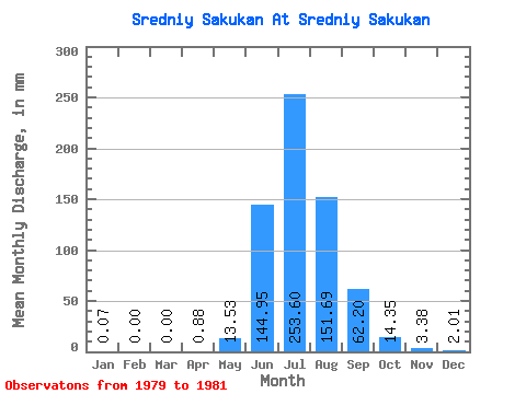
| Statistic | Jan | Feb | Mar | Apr | May | Jun | Jul | Aug | Sep | Oct | Nov | Dec | Annual |
|---|---|---|---|---|---|---|---|---|---|---|---|---|---|
| Mean | 0.07 | 0.00 | 0.00 | 0.88 | 13.52 | 144.96 | 253.56 | 151.66 | 62.20 | 14.35 | 3.39 | 2.01 | 641.91 |
| Standard Deviation | 0.10 | 0.00 | 0.00 | 0.57 | 15.34 | 7.81 | 93.01 | 66.30 | 27.68 | 7.08 | 0.05 | 1.08 | 114.86 |
| Min | 0.00 | 0.00 | 0.00 | 0.22 | 4.36 | 136.06 | 153.92 | 79.54 | 36.17 | 9.79 | 3.36 | 0.88 | 550.25 |
| Max | 0.19 | 0.00 | 0.00 | 1.21 | 31.23 | 150.70 | 338.09 | 209.97 | 91.28 | 22.51 | 3.44 | 3.02 | 770.76 |
| Coefficient of Variation | 1.42 | 0.65 | 1.13 | 0.05 | 0.37 | 0.44 | 0.45 | 0.49 | 0.01 | 0.54 | 0.18 |
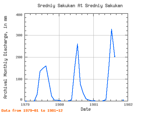
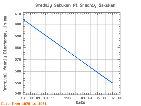
| Year | Jan | Feb | Mar | Apr | May | Jun | Jul | Aug | Sep | Oct | Nov | Dec | Annual | 1979 | 0.00 | 0.00 | 0.00 | 1.21 | 31.23 | 136.06 | 153.92 | 165.48 | 91.28 | 22.51 | 3.36 | 3.02 | 604.73 | 1980 | 0.19 | 0.00 | 0.00 | 0.22 | 4.36 | 150.70 | 268.69 | 79.54 | 36.17 | 9.79 | 3.44 | 0.88 | 550.25 | 1981 | 0.03 | 0.00 | 0.00 | 1.21 | 4.98 | 148.11 | 338.09 | 209.97 | 59.16 | 10.77 | 3.36 | 2.13 | 770.76 |
|---|
 Return to R-Arctic Net Home Page