|
|
|||||||||||||||||
| Point ID: 7819 | Downloads | Plots | Site Data | Code: 3162 |
|
|
|||||||||||||||||
| Download | |
|---|---|
| Site Descriptor Information | Site Time Series Data |
| Link to all available data | |
|
|
| View: | Statistics | Time Series |
| Units: | m3/s |
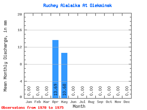
| Statistic | Jan | Feb | Mar | Apr | May | Jun | Jul | Aug | Sep | Oct | Nov | Dec | Annual |
|---|---|---|---|---|---|---|---|---|---|---|---|---|---|
| Mean | 0.00 | 0.00 | 0.00 | 13.72 | 10.72 | 0.00 | 0.00 | 0.00 | 0.00 | 0.00 | 0.00 | 0.00 | 23.12 |
| Standard Deviation | 0.00 | 0.00 | 0.00 | 8.90 | 12.72 | 0.00 | 0.00 | 0.00 | 0.00 | 0.00 | 0.00 | 0.00 | 19.40 |
| Min | 0.00 | 0.00 | 0.00 | 2.04 | 0.60 | 0.00 | 0.00 | 0.00 | 0.00 | 0.00 | 0.00 | 0.00 | 9.60 |
| Max | 0.00 | 0.00 | 0.00 | 23.30 | 28.59 | 0.00 | 0.00 | 0.00 | 0.00 | 0.00 | 0.00 | 0.00 | 51.71 |
| Coefficient of Variation | 0.65 | 1.19 | 0.84 |
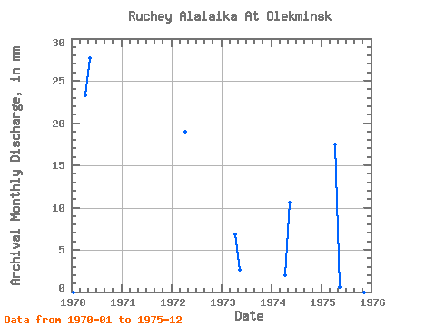
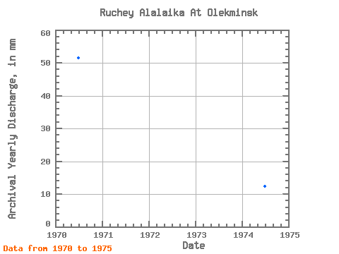
| Year | Jan | Feb | Mar | Apr | May | Jun | Jul | Aug | Sep | Oct | Nov | Dec | Annual | 1970 | 0.00 | 0.00 | 0.00 | 23.30 | 28.59 | 0.00 | 0.00 | 0.00 | 0.00 | 0.00 | 0.00 | 0.00 | 51.71 | 1972 | 0.00 | 0.00 | 0.00 | 18.93 | 0.00 | 0.00 | 0.00 | 0.00 | 0.00 | 0.00 | 0.00 | 1973 | 0.00 | 0.00 | 0.00 | 6.84 | 2.71 | 0.00 | 0.00 | 0.00 | 0.00 | 0.00 | 0.00 | 0.00 | 9.60 | 1974 | 0.00 | 0.00 | 0.00 | 2.04 | 10.98 | 0.00 | 0.00 | 0.00 | 0.00 | 0.00 | 0.00 | 0.00 | 12.85 | 1975 | 0.00 | 0.00 | 0.00 | 17.47 | 0.60 | 0.00 | 0.00 | 0.00 | 0.00 | 0.00 | 0.00 | 0.00 | 18.32 |
|---|
 Return to R-Arctic Net Home Page