|
|
|||||||||||||||||
| Point ID: 7817 | Downloads | Plots | Site Data | Code: 3151 |
|
|
|||||||||||||||||
| Download | |
|---|---|
| Site Descriptor Information | Site Time Series Data |
| Link to all available data | |
|
|
| View: | Statistics | Time Series |
| Units: | m3/s |
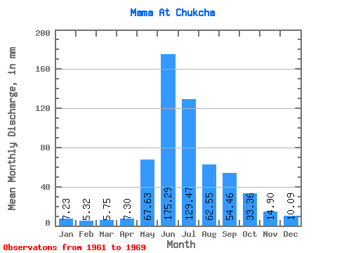
| Statistic | Jan | Feb | Mar | Apr | May | Jun | Jul | Aug | Sep | Oct | Nov | Dec | Annual |
|---|---|---|---|---|---|---|---|---|---|---|---|---|---|
| Mean | 7.23 | 5.37 | 5.75 | 7.30 | 67.62 | 175.29 | 129.45 | 62.54 | 54.46 | 33.35 | 14.90 | 10.09 | 572.66 |
| Standard Deviation | 1.94 | 1.56 | 0.57 | 3.63 | 21.63 | 49.52 | 45.99 | 15.78 | 13.03 | 5.03 | 3.82 | 2.83 | 77.29 |
| Min | 3.42 | 2.43 | 4.69 | 4.80 | 39.25 | 120.27 | 66.88 | 39.25 | 38.95 | 26.78 | 11.60 | 5.58 | 480.75 |
| Max | 10.03 | 7.77 | 6.64 | 15.91 | 94.37 | 271.54 | 199.79 | 82.32 | 70.90 | 42.93 | 22.49 | 15.59 | 669.55 |
| Coefficient of Variation | 0.27 | 0.29 | 0.10 | 0.50 | 0.32 | 0.28 | 0.35 | 0.25 | 0.24 | 0.15 | 0.26 | 0.28 | 0.14 |
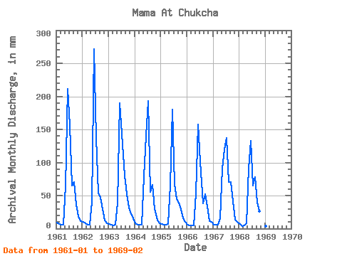
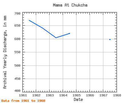
| Year | Jan | Feb | Mar | Apr | May | Jun | Jul | Aug | Sep | Oct | Nov | Dec | Annual | 1961 | 9.45 | 6.79 | 6.64 | 5.40 | 65.75 | 211.20 | 161.53 | 66.88 | 70.08 | 37.12 | 18.79 | 11.34 | 669.55 | 1962 | 10.03 | 7.77 | 5.81 | 5.92 | 41.94 | 271.54 | 143.11 | 55.12 | 47.18 | 30.32 | 12.75 | 8.60 | 640.37 | 1963 | 7.16 | 5.51 | 5.50 | 5.66 | 39.25 | 189.26 | 148.78 | 82.32 | 51.70 | 32.73 | 22.49 | 15.59 | 604.38 | 1964 | 8.40 | 5.94 | 6.09 | 5.77 | 82.18 | 139.89 | 199.79 | 56.68 | 65.97 | 31.03 | 12.69 | 8.81 | 619.94 | 1965 | 6.73 | 5.67 | 6.08 | 6.68 | 68.72 | 179.66 | 69.15 | 46.33 | 38.95 | 30.46 | 15.09 | 10.48 | 483.70 | 1966 | 6.60 | 4.60 | 4.69 | 4.80 | 54.55 | 157.71 | 105.28 | 39.25 | 51.70 | 35.42 | 11.60 | 10.02 | 485.31 | 1967 | 6.62 | 5.64 | 5.62 | 15.91 | 94.37 | 120.27 | 141.13 | 73.11 | 70.90 | 42.93 | 13.54 | 10.26 | 597.27 | 1968 | 6.67 | 3.94 | 5.53 | 8.27 | 94.23 | 132.75 | 66.88 | 80.62 | 39.22 | 26.78 | 12.27 | 5.58 | 480.75 | 1969 | 3.42 | 2.43 |
|---|
 Return to R-Arctic Net Home Page