|
|
|||||||||||||||||
| Point ID: 7811 | Downloads | Plots | Site Data | Code: 3139 |
|
|
|||||||||||||||||
| Download | |
|---|---|
| Site Descriptor Information | Site Time Series Data |
| Link to all available data | |
|
|
| View: | Statistics | Time Series |
| Units: | m3/s |
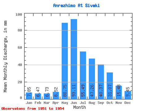
| Statistic | Jan | Feb | Mar | Apr | May | Jun | Jul | Aug | Sep | Oct | Nov | Dec | Annual |
|---|---|---|---|---|---|---|---|---|---|---|---|---|---|
| Mean | 7.85 | 6.53 | 6.73 | 8.51 | 88.74 | 93.11 | 55.48 | 47.25 | 40.37 | 31.06 | 15.48 | 9.45 | 408.95 |
| Standard Deviation | 2.57 | 1.56 | 1.24 | 1.98 | 24.50 | 19.41 | 18.55 | 25.67 | 13.95 | 8.90 | 2.92 | 2.20 | 92.17 |
| Min | 4.48 | 4.34 | 4.87 | 6.48 | 54.00 | 76.70 | 34.24 | 28.32 | 27.20 | 24.15 | 13.55 | 6.96 | 314.93 |
| Max | 10.05 | 7.82 | 7.49 | 10.71 | 108.66 | 121.10 | 72.00 | 83.41 | 58.00 | 44.12 | 19.82 | 12.31 | 532.01 |
| Coefficient of Variation | 0.33 | 0.24 | 0.18 | 0.23 | 0.28 | 0.21 | 0.33 | 0.54 | 0.35 | 0.29 | 0.19 | 0.23 | 0.23 |
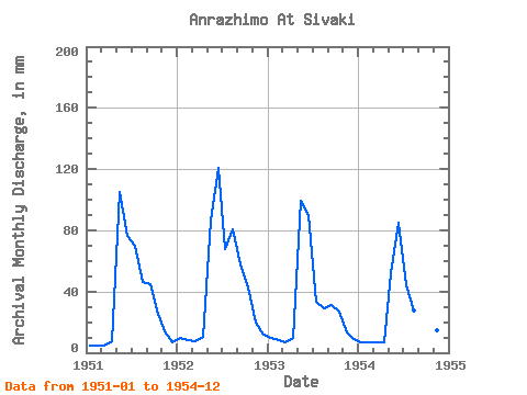
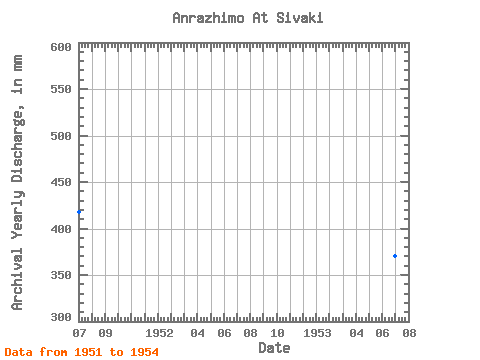
| Year | Jan | Feb | Mar | Apr | May | Jun | Jul | Aug | Sep | Oct | Nov | Dec | Annual | 1951 | 4.48 | 4.34 | 4.87 | 7.25 | 108.66 | 76.70 | 72.00 | 47.63 | 44.83 | 28.32 | 14.09 | 6.96 | 417.65 | 1952 | 9.64 | 7.82 | 7.49 | 10.71 | 89.56 | 121.10 | 70.02 | 83.41 | 58.00 | 44.12 | 19.82 | 12.31 | 532.01 | 1953 | 10.05 | 7.44 | 7.31 | 9.62 | 102.73 | 89.66 | 34.24 | 29.63 | 31.44 | 27.66 | 13.55 | 9.13 | 371.22 | 1954 | 7.24 | 6.52 | 7.24 | 6.48 | 54.00 | 84.98 | 45.66 | 28.32 | 27.20 | 24.15 | 14.45 | 9.39 | 314.93 |
|---|
 Return to R-Arctic Net Home Page