|
|
|||||||||||||||||
| Point ID: 7809 | Downloads | Plots | Site Data | Code: 3125 |
|
|
|||||||||||||||||
| Download | |
|---|---|
| Site Descriptor Information | Site Time Series Data |
| Link to all available data | |
|
|
| View: | Statistics | Time Series |
| Units: | m3/s |
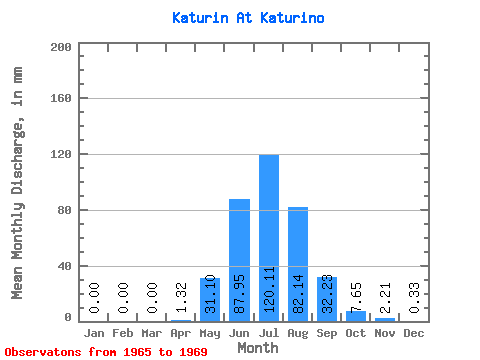
| Statistic | Jan | Feb | Mar | Apr | May | Jun | Jul | Aug | Sep | Oct | Nov | Dec | Annual |
|---|---|---|---|---|---|---|---|---|---|---|---|---|---|
| Mean | 0.00 | 0.00 | 0.00 | 1.32 | 31.10 | 87.95 | 120.09 | 82.12 | 32.23 | 7.64 | 2.21 | 0.33 | 362.49 |
| Standard Deviation | 0.00 | 0.00 | 0.00 | 2.91 | 23.10 | 51.04 | 40.31 | 33.17 | 14.71 | 3.19 | 1.25 | 0.46 | 52.94 |
| Min | 0.00 | 0.00 | 0.00 | 0.00 | 1.50 | 33.42 | 67.66 | 52.38 | 17.07 | 4.98 | 1.11 | 0.06 | 268.02 |
| Max | 0.00 | 0.00 | 0.00 | 6.53 | 65.07 | 160.29 | 175.95 | 129.20 | 55.02 | 12.76 | 4.34 | 1.13 | 392.52 |
| Coefficient of Variation | 2.20 | 0.74 | 0.58 | 0.34 | 0.40 | 0.46 | 0.42 | 0.56 | 1.38 | 0.15 |
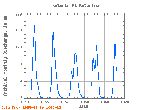
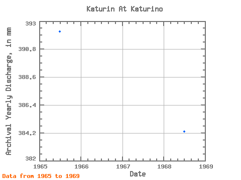
| Year | Jan | Feb | Mar | Apr | May | Jun | Jul | Aug | Sep | Oct | Nov | Dec | Annual | 1965 | 0.00 | 0.00 | 0.00 | 0.00 | 21.96 | 104.59 | 175.95 | 52.38 | 29.79 | 8.71 | 1.71 | 0.08 | 392.52 | 1966 | 0.00 | 0.00 | 0.00 | 0.09 | 35.71 | 160.29 | 105.94 | 57.55 | 17.07 | 6.04 | 2.16 | 0.30 | 384.12 | 1967 | 0.00 | 0.00 | 0.00 | 6.53 | 65.07 | 44.79 | 111.82 | 104.07 | 36.61 | 12.76 | 4.34 | 1.13 | 383.18 | 1968 | 0.00 | 0.00 | 0.00 | 0.00 | 31.24 | 96.63 | 67.66 | 129.20 | 55.02 | 4.98 | 1.73 | 0.06 | 384.60 | 1969 | 0.00 | 0.00 | 0.00 | 0.00 | 1.50 | 33.42 | 139.07 | 67.42 | 22.67 | 5.73 | 1.11 | 0.08 | 268.02 |
|---|
 Return to R-Arctic Net Home Page