|
|
|||||||||||||||||
| Point ID: 7806 | Downloads | Plots | Site Data | Code: 3116 |
|
|
|||||||||||||||||
| Download | |
|---|---|
| Site Descriptor Information | Site Time Series Data |
| Link to all available data | |
|
|
| View: | Statistics | Time Series |
| Units: | m3/s |
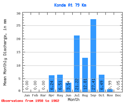
| Statistic | Jan | Feb | Mar | Apr | May | Jun | Jul | Aug | Sep | Oct | Nov | Dec | Annual |
|---|---|---|---|---|---|---|---|---|---|---|---|---|---|
| Mean | 0.00 | 0.00 | 0.00 | 6.25 | 6.51 | 3.54 | 21.21 | 12.81 | 27.41 | 6.49 | 0.99 | 0.05 | 69.96 |
| Standard Deviation | 0.00 | 0.00 | 0.00 | 4.45 | 7.81 | 3.85 | 31.64 | 8.80 | 26.98 | 5.17 | 1.14 | 0.07 | 36.37 |
| Min | 0.00 | 0.00 | 0.00 | 0.27 | 0.82 | 0.45 | 3.74 | 5.58 | 9.05 | 0.60 | 0.12 | 0.00 | 37.51 |
| Max | 0.00 | 0.00 | 0.00 | 9.68 | 17.88 | 8.96 | 68.60 | 25.59 | 67.46 | 11.19 | 2.66 | 0.17 | 109.27 |
| Coefficient of Variation | 0.71 | 1.20 | 1.09 | 1.49 | 0.69 | 0.98 | 0.80 | 1.16 | 1.40 | 0.52 |
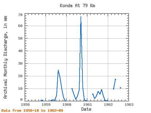
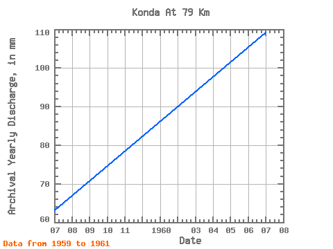
| Year | Jan | Feb | Mar | Apr | May | Jun | Jul | Aug | Sep | Oct | Nov | Dec | Annual | 1958 | 0.60 | 0.12 | 0.00 | 1959 | 0.00 | 0.00 | 0.00 | 0.27 | 0.82 | 0.45 | 4.74 | 25.59 | 18.38 | 10.46 | 2.66 | 0.17 | 63.09 | 1960 | 0.00 | 0.00 | 0.00 | 9.68 | 5.31 | 1.20 | 3.74 | 9.26 | 67.46 | 11.19 | 0.77 | 0.03 | 109.27 | 1961 | 0.00 | 0.00 | 0.00 | 5.45 | 2.04 | 3.53 | 7.78 | 5.58 | 9.05 | 3.72 | 0.41 | 0.02 | 37.51 | 1962 | 0.00 | 0.00 | 0.00 | 9.59 | 17.88 | 8.96 | 68.60 | 10.82 | 14.73 |
|---|
 Return to R-Arctic Net Home Page