|
|
|||||||||||||||||
| Point ID: 7792 | Downloads | Plots | Site Data | Code: 3066 |
|
|
|||||||||||||||||
| Download | |
|---|---|
| Site Descriptor Information | Site Time Series Data |
| Link to all available data | |
|
|
| View: | Statistics | Time Series |
| Units: | m3/s |
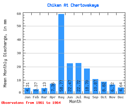
| Statistic | Jan | Feb | Mar | Apr | May | Jun | Jul | Aug | Sep | Oct | Nov | Dec | Annual |
|---|---|---|---|---|---|---|---|---|---|---|---|---|---|
| Mean | 4.31 | 3.40 | 4.13 | 7.36 | 58.76 | 22.47 | 22.71 | 18.70 | 10.87 | 8.82 | 6.71 | 4.64 | 171.98 |
| Standard Deviation | 1.45 | 1.64 | 1.95 | 5.54 | 24.73 | 10.46 | 15.74 | 10.47 | 2.93 | 2.47 | 2.54 | 1.70 | 53.58 |
| Min | 2.76 | 1.54 | 1.44 | 2.29 | 32.08 | 10.28 | 8.59 | 9.52 | 7.74 | 6.01 | 3.84 | 3.09 | 110.97 |
| Max | 5.80 | 5.42 | 5.86 | 15.26 | 91.62 | 32.50 | 42.28 | 28.82 | 13.55 | 10.67 | 8.64 | 6.46 | 211.38 |
| Coefficient of Variation | 0.34 | 0.48 | 0.47 | 0.75 | 0.42 | 0.47 | 0.69 | 0.56 | 0.27 | 0.28 | 0.38 | 0.37 | 0.31 |
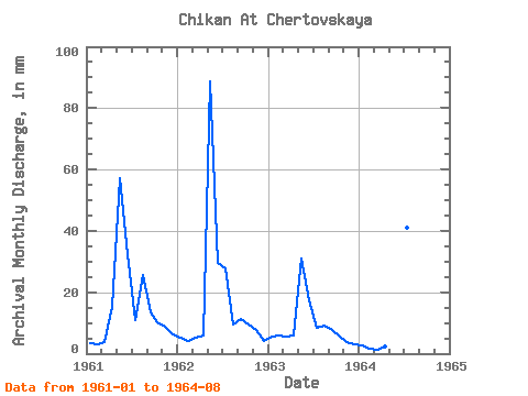
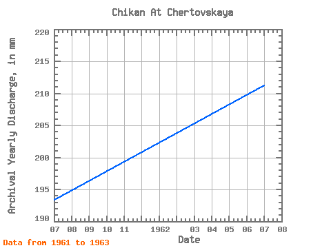
| Year | Jan | Feb | Mar | Apr | May | Jun | Jul | Aug | Sep | Oct | Nov | Dec | Annual | 1961 | 3.43 | 2.82 | 3.98 | 15.26 | 59.13 | 32.50 | 11.43 | 26.64 | 13.55 | 10.67 | 8.64 | 6.46 | 193.59 | 1962 | 5.26 | 3.80 | 5.23 | 5.91 | 91.62 | 29.74 | 28.55 | 9.81 | 11.33 | 9.77 | 7.66 | 4.36 | 211.38 | 1963 | 5.80 | 5.42 | 5.86 | 5.99 | 32.08 | 17.37 | 8.59 | 9.52 | 7.74 | 6.01 | 3.84 | 3.09 | 110.97 | 1964 | 2.76 | 1.54 | 1.44 | 2.29 | 52.20 | 10.28 | 42.28 | 28.82 |
|---|
 Return to R-Arctic Net Home Page