|
|
|||||||||||||||||
| Point ID: 7778 | Downloads | Plots | Site Data | Code: 10QB001 |
|
|
|||||||||||||||||
| Download | |
|---|---|
| Site Descriptor Information | Site Time Series Data |
| Link to all available data | |
|
|
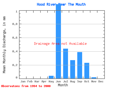
| View: | Statistics | Time Series |
| Units: | m3/s |
| Statistic | Jan | Feb | Mar | Apr | May | Jun | Jul | Aug | Sep | Oct | Nov | Dec | Annual |
|---|---|---|---|---|---|---|---|---|---|---|---|---|---|
| Mean | |||||||||||||
| Standard Deviation | |||||||||||||
| Min | |||||||||||||
| Max | |||||||||||||
| Coefficient of Variation | 2.00 | 1.07 | 0.27 | 0.26 | 0.33 | 0.41 | 0.68 | 0.59 | 0.38 |
| Year | Jan | Feb | Mar | Apr | May | Jun | Jul | Aug | Sep | Oct | Nov | Dec | Annual | 1994 | 1995 | 1996 | 1997 | 1998 | 1999 | 2000 |
|---|
 Return to R-Arctic Net Home Page