|
|
|||||||||||||||||
| Point ID: 7774 | Downloads | Plots | Site Data | Code: 10LC017 |
|
|
|||||||||||||||||
| Download | |
|---|---|
| Site Descriptor Information | Site Time Series Data |
| Link to all available data | |
|
|
| View: | Statistics | Time Series |
| Units: | m3/s |
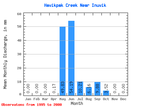
| Statistic | Jan | Feb | Mar | Apr | May | Jun | Jul | Aug | Sep | Oct | Nov | Dec | Annual |
|---|---|---|---|---|---|---|---|---|---|---|---|---|---|
| Mean | 0.00 | 0.00 | 0.00 | 0.14 | 49.77 | 54.25 | 10.18 | 6.23 | 9.88 | 3.52 | 0.00 | 0.00 | 158.91 |
| Standard Deviation | 0.00 | 0.00 | 0.00 | 0.30 | 36.07 | 50.93 | 5.42 | 4.92 | 5.93 | 4.38 | 0.00 | 0.00 | 15.73 |
| Min | 0.00 | 0.00 | 0.00 | 0.00 | 0.00 | 18.92 | 3.52 | 0.88 | 2.39 | 0.00 | 0.00 | 0.00 | 149.40 |
| Max | 0.00 | 0.00 | 0.00 | 0.68 | 103.88 | 156.27 | 16.55 | 13.03 | 18.75 | 9.86 | 0.00 | 0.00 | 177.06 |
| Coefficient of Variation | 2.24 | 0.72 | 0.94 | 0.53 | 0.79 | 0.60 | 1.24 | 0.10 |
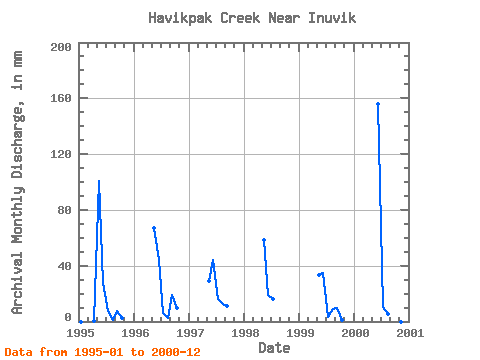
| Year | Jan | Feb | Mar | Apr | May | Jun | Jul | Aug | Sep | Oct | Nov | Dec | Annual | 1995 | 0.00 | 0.00 | 0.00 | 0.68 | 103.88 | 27.27 | 7.57 | 0.88 | 7.84 | 2.82 | 0.00 | 0.00 | 149.40 | 1996 | 0.00 | 0.00 | 0.00 | 0.00 | 69.19 | 44.31 | 6.16 | 2.64 | 18.75 | 9.86 | 0.00 | 0.00 | 150.26 | 1997 | 0.00 | 0.00 | 0.00 | 0.00 | 30.28 | 43.97 | 16.37 | 13.03 | 11.08 | 1998 | 0.00 | 0.00 | 0.00 | 0.00 | 60.57 | 18.92 | 16.55 | 1999 | 34.69 | 34.76 | 3.52 | 9.16 | 9.37 | 1.41 | 2000 | 0.00 | 0.00 | 0.00 | 0.00 | 0.00 | 156.27 | 10.92 | 5.46 | 2.39 | 0.00 | 0.00 | 0.00 | 177.06 |
|---|
 Return to R-Arctic Net Home Page