|
|
|||||||||||||||||
| Point ID: 7771 | Downloads | Plots | Site Data | Code: 10DA001 |
|
|
|||||||||||||||||
| Download | |
|---|---|
| Site Descriptor Information | Site Time Series Data |
| Link to all available data | |
|
|
| View: | Statistics | Time Series |
| Units: | m3/s |
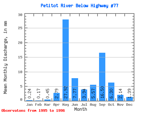
| Statistic | Jan | Feb | Mar | Apr | May | Jun | Jul | Aug | Sep | Oct | Nov | Dec | Annual |
|---|---|---|---|---|---|---|---|---|---|---|---|---|---|
| Mean | 0.24 | 0.17 | 0.45 | 2.79 | 27.92 | 7.77 | 3.94 | 5.57 | 16.50 | 6.30 | 2.14 | 1.39 | 74.81 |
| Standard Deviation | 0.03 | 0.02 | 0.50 | 3.25 | 7.69 | 4.02 | 3.37 | 4.95 | 21.82 | 7.52 | 2.13 | 1.50 | 50.16 |
| Min | 0.21 | 0.16 | 0.09 | 0.49 | 22.48 | 4.93 | 1.55 | 2.07 | 1.07 | 0.98 | 0.63 | 0.34 | 39.34 |
| Max | 0.26 | 0.18 | 0.80 | 5.09 | 33.35 | 10.61 | 6.32 | 9.07 | 31.94 | 11.62 | 3.65 | 2.45 | 110.27 |
| Coefficient of Variation | 0.12 | 0.10 | 1.13 | 1.16 | 0.28 | 0.52 | 0.86 | 0.89 | 1.32 | 1.19 | 1.00 | 1.07 | 0.67 |
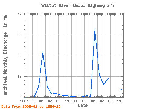
| Year | Jan | Feb | Mar | Apr | May | Jun | Jul | Aug | Sep | Oct | Nov | Dec | Annual | 1995 | 0.26 | 0.16 | 0.09 | 5.09 | 22.48 | 4.93 | 1.55 | 2.07 | 1.07 | 0.98 | 0.63 | 0.34 | 39.34 | 1996 | 0.21 | 0.18 | 0.80 | 0.49 | 33.35 | 10.61 | 6.32 | 9.07 | 31.94 | 11.62 | 3.65 | 2.45 | 110.27 |
|---|
 Return to R-Arctic Net Home Page