|
|
|||||||||||||||||
| Point ID: 7721 | Downloads | Plots | Site Data | Code: II005 |
|
|
|||||||||||||||||
| Download | |
|---|---|
| Site Descriptor Information | Site Time Series Data |
| Link to all available data | |
|
|
| View: | Statistics | Time Series |
| Units: | m3/s |
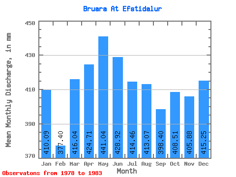
| Statistic | Jan | Feb | Mar | Apr | May | Jun | Jul | Aug | Sep | Oct | Nov | Dec | Annual |
|---|---|---|---|---|---|---|---|---|---|---|---|---|---|
| Mean | 410.03 | 380.64 | 415.98 | 424.70 | 440.98 | 428.93 | 414.40 | 413.01 | 398.40 | 408.44 | 405.89 | 415.19 | 4958.23 |
| Standard Deviation | 8.77 | 13.77 | 21.58 | 28.51 | 33.45 | 25.78 | 12.52 | 22.23 | 18.86 | 14.53 | 20.86 | 21.85 | 99.96 |
| Min | 401.11 | 362.20 | 393.96 | 389.38 | 403.49 | 405.50 | 401.11 | 393.96 | 377.86 | 384.44 | 377.86 | 379.68 | 4842.71 |
| Max | 422.53 | 400.16 | 453.48 | 472.32 | 474.90 | 466.56 | 432.05 | 449.90 | 426.24 | 424.91 | 429.70 | 441.57 | 5094.02 |
| Coefficient of Variation | 0.02 | 0.04 | 0.05 | 0.07 | 0.08 | 0.06 | 0.03 | 0.05 | 0.05 | 0.04 | 0.05 | 0.05 | 0.02 |
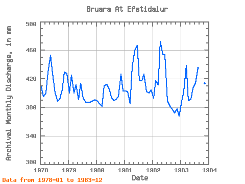
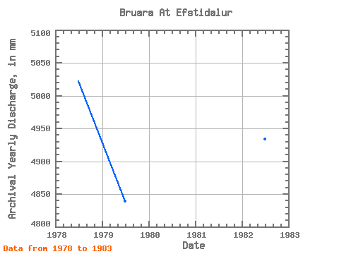
| Year | Jan | Feb | Mar | Apr | May | Jun | Jul | Aug | Sep | Oct | Nov | Dec | Annual | 1978 | 422.53 | 371.96 | 413.01 | 428.54 | 467.76 | 427.39 | 413.01 | 401.11 | 391.68 | 417.77 | 429.70 | 441.57 | 5026.22 | 1979 | 413.01 | 400.16 | 413.01 | 411.26 | 403.49 | 413.57 | 405.87 | 399.92 | 387.07 | 399.92 | 388.22 | 403.49 | 4842.71 | 1980 | 401.11 | 362.20 | 393.96 | 410.11 | 426.10 | 405.50 | 407.06 | 402.30 | 390.53 | 408.25 | 426.24 | 416.58 | 4850.89 | 1981 | 416.58 | 378.47 | 397.53 | 436.61 | 474.90 | 466.56 | 432.05 | 430.86 | 426.24 | 415.39 | 399.74 | 417.77 | 5094.02 | 1982 | 405.87 | 392.57 | 424.91 | 472.32 | 468.95 | 453.89 | 401.11 | 393.96 | 377.86 | 384.44 | 377.86 | 379.68 | 4937.39 | 1983 | 401.11 | 378.47 | 453.48 | 389.38 | 404.68 | 406.66 | 427.29 | 449.90 | 417.02 | 424.91 | 413.57 | 432.05 | 4998.17 |
|---|
 Return to R-Arctic Net Home Page