|
|
|||||||||||||||||
| Point ID: 7694 | Downloads | Plots | Site Data | Code: 15388100 |
|
|
|||||||||||||||||
| Download | |
|---|---|
| Site Descriptor Information | Site Time Series Data |
| Link to all available data | |
|
|
| View: | Statistics | Time Series |
| Units: | m3/s |
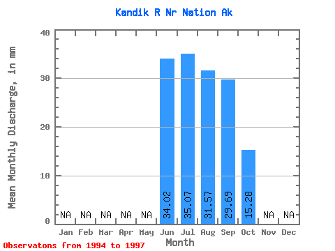
| Statistic | Jan | Feb | Mar | Apr | May | Jun | Jul | Aug | Sep | Oct | Nov | Dec | Annual |
|---|---|---|---|---|---|---|---|---|---|---|---|---|---|
| Mean | 34.02 | 35.07 | 31.56 | 29.69 | 15.28 | ||||||||
| Standard Deviation | 24.05 | 15.16 | 14.12 | 16.24 | |||||||||
| Min | 17.02 | 19.89 | 15.36 | 18.52 | 15.28 | ||||||||
| Max | 51.03 | 50.21 | 41.30 | 48.31 | 15.28 | ||||||||
| Coefficient of Variation | 0.71 | 0.43 | 0.45 | 0.55 |
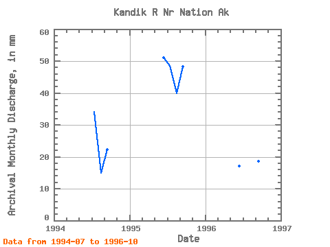
| Year | Jan | Feb | Mar | Apr | May | Jun | Jul | Aug | Sep | Oct | Nov | Dec | Annual | 1994 | 35.11 | 15.36 | 22.23 | 1995 | 51.03 | 50.21 | 41.30 | 48.31 | 1996 | 17.02 | 19.89 | 38.03 | 18.52 | 15.28 | 1997 |
|---|
 Return to R-Arctic Net Home Page