|
|
|||||||||||||||||
| Point ID: 7685 | Downloads | Plots | Site Data | Code: 15518300 |
|
|
|||||||||||||||||
| Download | |
|---|---|
| Site Descriptor Information | Site Time Series Data |
| Link to all available data | |
|
|
| View: | Statistics | Time Series |
| Units: | m3/s |
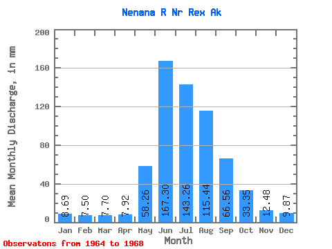
| Statistic | Jan | Feb | Mar | Apr | May | Jun | Jul | Aug | Sep | Oct | Nov | Dec | Annual |
|---|---|---|---|---|---|---|---|---|---|---|---|---|---|
| Mean | 8.69 | 7.57 | 7.70 | 7.92 | 58.25 | 167.30 | 143.24 | 115.42 | 66.56 | 33.34 | 12.48 | 9.87 | 624.88 |
| Standard Deviation | 0.60 | 0.68 | 0.78 | 0.82 | 15.27 | 41.28 | 28.49 | 46.46 | 23.21 | 8.19 | 3.42 | 0.99 | 57.08 |
| Min | 8.00 | 6.58 | 6.57 | 6.94 | 42.87 | 134.90 | 111.34 | 83.55 | 36.16 | 23.14 | 9.94 | 8.86 | 590.02 |
| Max | 9.20 | 8.05 | 8.36 | 8.90 | 78.92 | 225.53 | 180.59 | 182.26 | 91.68 | 42.69 | 17.34 | 11.23 | 690.76 |
| Coefficient of Variation | 0.07 | 0.09 | 0.10 | 0.10 | 0.26 | 0.25 | 0.20 | 0.40 | 0.35 | 0.25 | 0.27 | 0.10 | 0.09 |
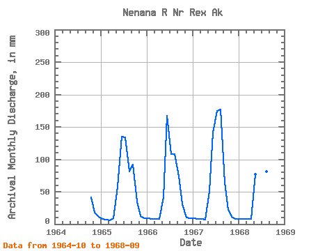
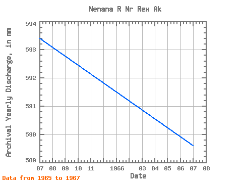
| Year | Jan | Feb | Mar | Apr | May | Jun | Jul | Aug | Sep | Oct | Nov | Dec | Annual | 1964 | 42.69 | 17.34 | 11.23 | 1965 | 8.00 | 6.58 | 6.57 | 8.90 | 58.92 | 134.91 | 138.54 | 83.55 | 91.68 | 35.91 | 12.43 | 9.84 | 593.86 | 1966 | 9.20 | 8.01 | 8.00 | 7.71 | 42.87 | 167.39 | 111.34 | 111.76 | 74.02 | 31.64 | 9.94 | 9.55 | 590.03 | 1967 | 9.20 | 8.05 | 7.88 | 6.94 | 52.30 | 141.38 | 180.59 | 182.26 | 64.38 | 23.14 | 10.22 | 8.86 | 690.76 | 1968 | 8.36 | 7.62 | 8.36 | 8.15 | 78.92 | 225.53 | 142.49 | 84.14 | 36.16 |
|---|
 Return to R-Arctic Net Home Page