|
|
|||||||||||||||||
| Point ID: 7578 | Downloads | Plots | Site Data | Code: 71039 |
|
|
|||||||||||||||||
| Download | |
|---|---|
| Site Descriptor Information | Site Time Series Data |
| Link to all available data | |
|
|
| View: | Statistics | Time Series |
| Units: | m3/s |
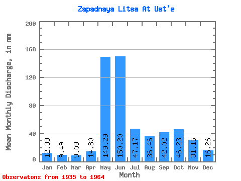
| Statistic | Jan | Feb | Mar | Apr | May | Jun | Jul | Aug | Sep | Oct | Nov | Dec | Annual |
|---|---|---|---|---|---|---|---|---|---|---|---|---|---|
| Mean | 12.39 | 9.57 | 9.09 | 14.80 | 149.26 | 150.20 | 47.16 | 36.46 | 42.02 | 46.22 | 31.15 | 16.26 | 567.27 |
| Standard Deviation | 5.21 | 3.10 | 2.40 | 11.06 | 76.74 | 81.55 | 23.04 | 19.70 | 20.39 | 18.92 | 13.09 | 7.39 | 108.06 |
| Min | 6.21 | 4.24 | 4.03 | 4.05 | 22.95 | 38.34 | 13.77 | 7.83 | 11.13 | 17.69 | 7.25 | 8.12 | 334.34 |
| Max | 24.08 | 15.11 | 13.14 | 53.80 | 339.81 | 322.37 | 103.07 | 90.47 | 103.90 | 89.57 | 52.93 | 36.23 | 753.90 |
| Coefficient of Variation | 0.42 | 0.32 | 0.26 | 0.75 | 0.51 | 0.54 | 0.49 | 0.54 | 0.48 | 0.41 | 0.42 | 0.46 | 0.19 |
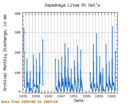
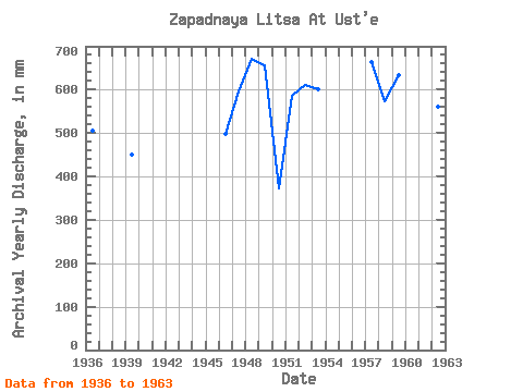
| Year | Jan | Feb | Mar | Apr | May | Jun | Jul | Aug | Sep | Oct | Nov | Dec | Annual | 1935 | 322.37 | 87.54 | 39.61 | 27.66 | 1936 | 10.17 | 7.57 | 7.85 | 17.43 | 175.53 | 43.13 | 28.13 | 31.73 | 49.01 | 49.96 | 52.93 | 36.23 | 506.55 | 1937 | 8.82 | 8.63 | 8.10 | 31.80 | 110.27 | 38.34 | 13.77 | 7.83 | 11.13 | 21.33 | 1938 | 6.44 | 8.35 | 9.52 | 122.87 | 190.59 | 86.19 | 33.76 | 43.34 | 33.31 | 8.26 | 1939 | 6.37 | 6.36 | 5.85 | 6.21 | 82.59 | 167.28 | 39.61 | 25.20 | 31.58 | 39.16 | 29.62 | 9.61 | 449.64 | 1940 | 6.21 | 4.24 | 4.03 | 4.05 | 203.89 | 69.70 | 51.76 | 1941 | 42.53 | 261.38 | 1945 | 165.10 | 26.78 | 14.58 | 20.06 | 32.41 | 13.57 | 9.23 | 1946 | 8.03 | 7.30 | 7.38 | 7.41 | 121.97 | 164.67 | 35.78 | 30.61 | 53.15 | 31.06 | 18.89 | 12.65 | 498.60 | 1947 | 10.69 | 9.14 | 9.41 | 17.34 | 184.31 | 122.41 | 38.03 | 42.31 | 35.72 | 71.56 | 40.95 | 16.77 | 595.84 | 1948 | 10.64 | 7.32 | 7.47 | 10.59 | 252.05 | 126.77 | 35.78 | 31.06 | 54.45 | 78.54 | 36.16 | 24.08 | 670.94 | 1949 | 17.55 | 14.04 | 11.30 | 17.69 | 229.54 | 116.97 | 46.13 | 44.33 | 29.19 | 74.49 | 44.43 | 15.01 | 656.97 | 1950 | 8.69 | 6.64 | 5.24 | 26.36 | 124.22 | 59.25 | 33.76 | 14.92 | 22.43 | 44.11 | 17.82 | 10.22 | 371.69 | 1951 | 10.40 | 8.53 | 9.36 | 10.63 | 80.56 | 160.53 | 103.07 | 54.01 | 60.99 | 42.98 | 30.71 | 15.53 | 586.16 | 1952 | 13.01 | 10.09 | 8.10 | 8.19 | 81.02 | 233.06 | 61.21 | 90.47 | 51.62 | 39.16 | 7.25 | 8.12 | 611.09 | 1953 | 11.50 | 9.84 | 10.98 | 12.00 | 219.42 | 126.99 | 24.75 | 64.36 | 50.10 | 34.66 | 26.79 | 13.07 | 601.61 | 1956 | 98.02 | 27.68 | 22.50 | 32.67 | 54.46 | 25.70 | 14.70 | 1957 | 10.73 | 8.59 | 8.60 | 11.06 | 147.63 | 241.78 | 69.31 | 29.03 | 42.47 | 44.78 | 37.25 | 13.64 | 664.62 | 1958 | 13.01 | 12.90 | 12.83 | 10.09 | 22.95 | 294.05 | 71.34 | 29.71 | 26.57 | 35.11 | 24.39 | 17.49 | 573.01 | 1959 | 13.62 | 11.95 | 11.01 | 8.10 | 186.11 | 52.28 | 39.38 | 61.89 | 103.90 | 89.57 | 46.18 | 14.45 | 634.98 | 1960 | 8.66 | 8.22 | 9.20 | 53.80 | 126.70 | 46.61 | 16.25 | 7.88 | 17.38 | 17.69 | 12.09 | 10.85 | 334.34 | 1961 | 11.19 | 9.19 | 9.86 | 9.95 | 52.66 | 241.78 | 48.83 | 31.51 | 50.97 | 41.18 | 42.04 | 22.23 | 573.25 | 1962 | 20.75 | 13.88 | 11.63 | 15.12 | 161.35 | 106.08 | 42.98 | 61.66 | 33.98 | 26.55 | 41.60 | 27.23 | 560.48 | 1963 | 24.08 | 15.01 | 13.14 | 12.33 | 339.81 | 107.60 | 41.86 | 38.03 | 43.56 | 54.46 | 43.56 | 25.88 | 753.90 | 1964 | 23.63 | 15.11 | 11.19 | 11.24 | 215.81 | 198.21 | 61.89 | 31.51 | 74.49 | 60.31 |
|---|
 Return to R-Arctic Net Home Page