|
|
|||||||||||||||||
| Point ID: 7503 | Downloads | Plots | Site Data | Other Close Sites | Code: 70495 |
|
|
|||||||||||||||||
| Download | |
|---|---|
| Site Descriptor Information | Site Time Series Data |
| Link to all available data | |
|
|
| View: | Statistics | Time Series |
| Units: | m3/s |
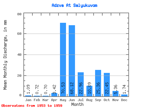
| Statistic | Jan | Feb | Mar | Apr | May | Jun | Jul | Aug | Sep | Oct | Nov | Dec | Annual |
|---|---|---|---|---|---|---|---|---|---|---|---|---|---|
| Mean | 1.09 | 0.73 | 0.70 | 3.42 | 70.52 | 68.12 | 22.96 | 10.09 | 25.36 | 22.45 | 5.36 | 1.74 | 232.22 |
| Standard Deviation | 0.28 | 0.15 | 0.13 | 4.69 | 34.80 | 45.85 | 7.59 | 7.08 | 13.22 | 10.82 | 2.76 | 0.57 | 36.30 |
| Min | 0.60 | 0.45 | 0.46 | 0.67 | 1.54 | 27.68 | 11.51 | 5.21 | 13.84 | 11.15 | 2.26 | 1.13 | 166.66 |
| Max | 1.39 | 0.89 | 0.89 | 13.47 | 97.47 | 150.05 | 32.06 | 24.23 | 45.67 | 36.62 | 9.15 | 2.81 | 262.33 |
| Coefficient of Variation | 0.26 | 0.21 | 0.19 | 1.37 | 0.49 | 0.67 | 0.33 | 0.70 | 0.52 | 0.48 | 0.52 | 0.33 | 0.16 |
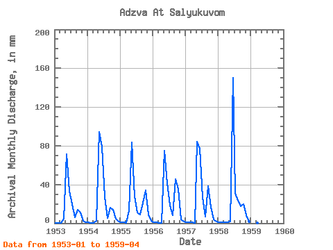
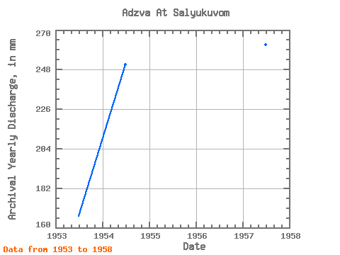
| Year | Jan | Feb | Mar | Apr | May | Jun | Jul | Aug | Sep | Oct | Nov | Dec | Annual | 1953 | 0.60 | 0.45 | 0.46 | 4.83 | 73.78 | 33.33 | 20.04 | 5.99 | 13.84 | 11.15 | 2.26 | 1.13 | 166.66 | 1954 | 0.95 | 0.61 | 0.61 | 2.66 | 97.47 | 79.52 | 28.05 | 5.21 | 15.92 | 14.66 | 4.51 | 1.90 | 250.97 | 1955 | 1.36 | 0.79 | 0.72 | 13.47 | 86.35 | 27.68 | 11.51 | 8.95 | 20.81 | 35.16 | 9.15 | 2.81 | 217.23 | 1956 | 1.39 | 0.89 | 0.71 | 0.70 | 77.24 | 40.91 | 18.58 | 8.82 | 45.67 | 36.62 | 3.74 | 1.59 | 235.66 | 1957 | 1.23 | 0.82 | 0.75 | 0.67 | 86.72 | 77.23 | 27.51 | 7.34 | 38.09 | 17.05 | 4.11 | 1.54 | 262.33 | 1958 | 1.11 | 0.80 | 0.89 | 0.86 | 1.54 | 150.05 | 32.06 | 24.23 | 17.81 | 20.04 | 8.38 | 1.50 | 260.47 | 1959 | 0.97 | 0.74 | 0.73 | 0.78 |
|---|
| Other Close Sites | ||||||
|---|---|---|---|---|---|---|
| PointID | Latitude | Longitude | Drainage Area | Source | Name | |
| 7498 | "Usa At Adzva-Vom" | 66.55 | -1317360 | SHI | 165.00 | |
 Return to R-Arctic Net Home Page