|
|
|||||||||||||||||
| Point ID: 738 | Downloads | Plots | Site Data | Code: 07FD910 |
|
|
|||||||||||||||||
| Download | |
|---|---|
| Site Descriptor Information | Site Time Series Data |
| Link to all available data | |
|
|
| View: | Statistics | Time Series |
| Units: | m3/s |
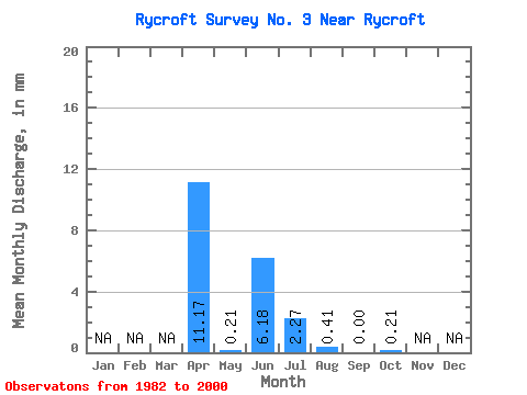
| Statistic | Jan | Feb | Mar | Apr | May | Jun | Jul | Aug | Sep | Oct | Nov | Dec | Annual |
|---|---|---|---|---|---|---|---|---|---|---|---|---|---|
| Mean | 11.14 | 0.20 | 6.11 | 2.25 | 0.34 | 0.09 | 0.19 | ||||||
| Standard Deviation | 15.17 | 0.48 | 21.14 | 6.04 | 1.10 | 0.37 | 0.66 | ||||||
| Min | 0.00 | 0.00 | 0.00 | 0.00 | 0.00 | 0.00 | 0.00 | ||||||
| Max | 54.43 | 1.85 | 92.71 | 25.96 | 4.53 | 1.59 | 2.68 | ||||||
| Coefficient of Variation | 1.36 | 2.48 | 3.46 | 2.68 | 3.28 | 3.88 | 3.39 |
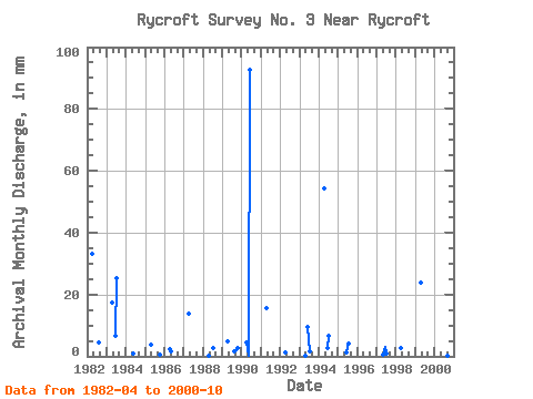
| Year | Jan | Feb | Mar | Apr | May | Jun | Jul | Aug | Sep | Oct | Nov | Dec | Annual | 1982 | 33.10 | 0.00 | 0.00 | 0.00 | 4.53 | 0.00 | 0.00 | 1983 | 17.55 | 0.00 | 6.58 | 25.96 | 0.00 | 0.00 | 0.00 | 1984 | 0.00 | 1.03 | 0.00 | 0.00 | 0.00 | 0.00 | 0.00 | 1985 | 3.59 | 0.00 | 0.00 | 0.00 | 0.00 | 0.00 | 0.62 | 1986 | 2.39 | 1.85 | 0.00 | 0.00 | 0.00 | 0.00 | 0.00 | 1987 | 13.96 | 0.00 | 0.00 | 0.00 | 0.00 | 0.00 | 0.00 | 1988 | 0.20 | 0.00 | 0.00 | 2.68 | 0.00 | 0.00 | 0.00 | 1989 | 4.99 | 0.00 | 0.00 | 0.00 | 1.85 | 1.59 | 2.68 | 1990 | 4.59 | 0.21 | 92.71 | 0.00 | 0.00 | 0.00 | 0.00 | 1991 | 15.55 | 0.00 | 0.00 | 0.00 | 0.00 | 0.00 | 0.00 | 1992 | 1.20 | 0.00 | 0.00 | 0.00 | 0.00 | 0.00 | 0.00 | 1993 | 0.20 | 0.00 | 9.57 | 1.85 | 0.00 | 0.00 | 0.00 | 1994 | 54.43 | 0.00 | 2.79 | 7.00 | 0.00 | 0.00 | 0.00 | 1995 | 0.00 | 1.20 | 4.33 | 0.00 | 0.00 | 0.00 | 1996 | 0.00 | 0.00 | 0.00 | 0.00 | 0.00 | 0.00 | 1997 | 0.62 | 3.19 | 1.03 | 0.00 | 0.00 | 1998 | 2.79 | 0.00 | 0.00 | 0.00 | 0.00 | 0.00 | 1999 | 23.73 | 0.00 | 0.00 | 0.00 | 0.00 | 0.00 | 0.00 | 2000 | 0.00 | 0.00 | 0.00 | 0.00 | 0.00 | 0.20 | 0.00 |
|---|
 Return to R-Arctic Net Home Page