|
|
|||||||||||||||||
| Point ID: 720 | Downloads | Plots | Site Data | Code: 07DB002 |
|
|
|||||||||||||||||
| Download | |
|---|---|
| Site Descriptor Information | Site Time Series Data |
| Link to all available data | |
|
|
| View: | Statistics | Time Series |
| Units: | m3/s |
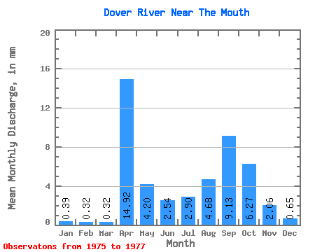
| Statistic | Jan | Feb | Mar | Apr | May | Jun | Jul | Aug | Sep | Oct | Nov | Dec | Annual |
|---|---|---|---|---|---|---|---|---|---|---|---|---|---|
| Mean | 0.39 | 0.32 | 0.32 | 14.93 | 4.20 | 2.54 | 2.90 | 4.68 | 9.13 | 6.27 | 2.06 | 0.65 | 17.03 |
| Standard Deviation | 0.27 | 0.31 | 0.35 | 16.01 | 2.68 | 0.25 | 0.31 | 5.35 | 10.81 | 5.37 | 1.76 | 0.28 | |
| Min | 0.20 | 0.10 | 0.08 | 3.61 | 2.30 | 2.36 | 2.67 | 0.56 | 0.89 | 2.47 | 0.82 | 0.42 | 17.03 |
| Max | 0.58 | 0.55 | 0.57 | 26.24 | 6.09 | 2.72 | 3.12 | 10.73 | 21.37 | 10.07 | 3.31 | 0.96 | 17.03 |
| Coefficient of Variation | 0.68 | 0.96 | 1.07 | 1.07 | 0.64 | 0.10 | 0.11 | 1.14 | 1.18 | 0.86 | 0.85 | 0.42 |
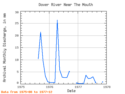
| Year | Jan | Feb | Mar | Apr | May | Jun | Jul | Aug | Sep | Oct | Nov | Dec | Annual | 1975 | 10.73 | 21.37 | 10.07 | 3.31 | 0.96 | 1976 | 0.58 | 0.55 | 0.57 | 26.24 | 6.09 | 2.72 | 2.67 | 2.76 | 5.14 | 0.42 | 1977 | 0.20 | 0.10 | 0.08 | 3.61 | 2.30 | 2.36 | 3.12 | 0.56 | 0.89 | 2.47 | 0.82 | 0.57 | 17.03 |
|---|
 Return to R-Arctic Net Home Page