|
|
|||||||||||||||||
| Point ID: 7141 | Downloads | Plots | Site Data | Other Close Sites | Code: 11668 |
|
|
|||||||||||||||||
| Download | |
|---|---|
| Site Descriptor Information | Site Time Series Data |
| Link to all available data | |
|
|
| View: | Statistics | Time Series |
| Units: | m3/s |
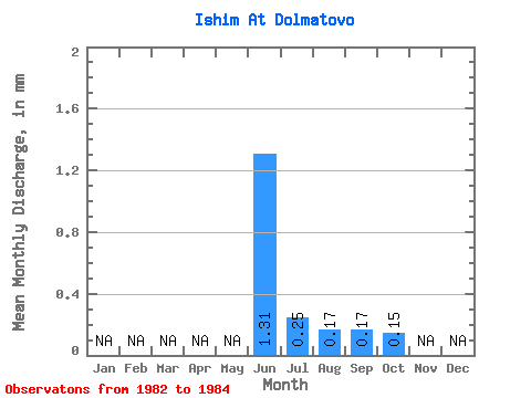
| Statistic | Jan | Feb | Mar | Apr | May | Jun | Jul | Aug | Sep | Oct | Nov | Dec | Annual |
|---|---|---|---|---|---|---|---|---|---|---|---|---|---|
| Mean | 1.04 | 0.20 | 0.13 | 0.14 | 0.12 | ||||||||
| Standard Deviation | 0.34 | 0.12 | 0.01 | 0.03 | 0.02 | ||||||||
| Min | 0.80 | 0.11 | 0.13 | 0.11 | 0.11 | ||||||||
| Max | 1.28 | 0.28 | 0.14 | 0.16 | 0.13 | ||||||||
| Coefficient of Variation | 0.33 | 0.60 | 0.05 | 0.24 | 0.14 |
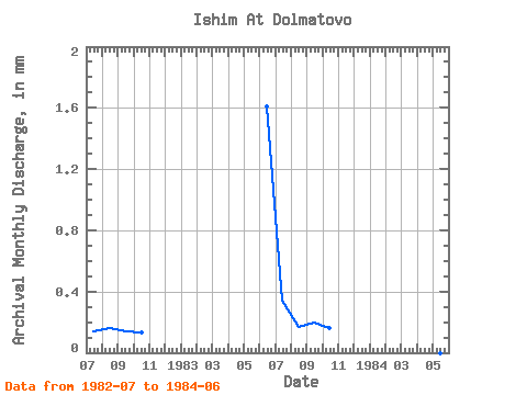
| Year | Jan | Feb | Mar | Apr | May | Jun | Jul | Aug | Sep | Oct | Nov | Dec | Annual | 1982 | 0.11 | 0.13 | 0.11 | 0.11 | 1983 | 1.28 | 0.28 | 0.14 | 0.16 | 0.13 | 1984 | 0.80 |
|---|
| Other Close Sites | ||||||
|---|---|---|---|---|---|---|
| PointID | Latitude | Longitude | Drainage Area | Source | Name | |
| 7056 | "Ishim At Il'inka" | 55.45 | -1334451 | SHI | 658.00 | |
 Return to R-Arctic Net Home Page