|
|
|||||||||||||||||
| Point ID: 7140 | Downloads | Plots | Site Data | Other Close Sites | Code: 11667 |
|
|
|||||||||||||||||
| Download | |
|---|---|
| Site Descriptor Information | Site Time Series Data |
| Link to all available data | |
|
|
| View: | Statistics | Time Series |
| Units: | m3/s |
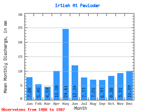
| Statistic | Jan | Feb | Mar | Apr | May | Jun | Jul | Aug | Sep | Oct | Nov | Dec | Annual |
|---|---|---|---|---|---|---|---|---|---|---|---|---|---|
| Mean | 5.24 | 3.62 | 3.05 | 6.70 | 16.36 | 8.01 | 5.16 | 4.66 | 4.63 | 5.57 | 6.19 | 6.71 | 79.23 |
| Standard Deviation | 0.19 | 1.49 | 1.63 | 0.56 | 1.02 | 0.47 | 1.22 | 1.86 | |||||
| Min | 5.24 | 3.62 | 2.92 | 5.64 | 15.21 | 7.61 | 4.44 | 4.33 | 3.77 | 4.25 | 6.19 | 6.71 | 79.23 |
| Max | 5.24 | 3.62 | 3.18 | 7.75 | 17.51 | 8.40 | 5.88 | 4.99 | 5.49 | 6.88 | 6.19 | 6.71 | 79.23 |
| Coefficient of Variation | 0.06 | 0.22 | 0.10 | 0.07 | 0.20 | 0.10 | 0.26 | 0.33 |
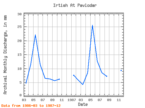
| Year | Jan | Feb | Mar | Apr | May | Jun | Jul | Aug | Sep | Oct | Nov | Dec | Annual | 1986 | 3.18 | 7.75 | 15.21 | 7.61 | 4.44 | 4.33 | 3.77 | 4.25 | 1987 | 5.24 | 3.62 | 2.92 | 5.64 | 17.51 | 8.40 | 5.88 | 4.99 | 5.49 | 6.88 | 6.19 | 6.71 | 79.23 |
|---|
| Other Close Sites | ||||||
|---|---|---|---|---|---|---|
| PointID | Latitude | Longitude | Drainage Area | Source | Name | |
| 6948 | "Irtish At Pavlodar" | 52.25 | -932209 | SHI | 2396.00 | |
 Return to R-Arctic Net Home Page