|
|
|||||||||||||||||
| Point ID: 713 | Downloads | Plots | Site Data | Code: 07DA014 |
|
|
|||||||||||||||||
| Download | |
|---|---|
| Site Descriptor Information | Site Time Series Data |
| Link to all available data | |

|
|
| View: | Statistics | Time Series |
| Units: | m3/s |
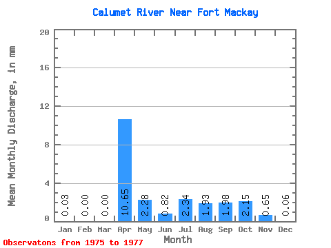
| Statistic | Jan | Feb | Mar | Apr | May | Jun | Jul | Aug | Sep | Oct | Nov | Dec | Annual |
|---|---|---|---|---|---|---|---|---|---|---|---|---|---|
| Mean | 0.02 | 0.00 | 0.00 | 10.65 | 2.29 | 0.81 | 2.33 | 1.93 | 1.98 | 2.15 | 0.66 | 0.05 | 20.34 |
| Standard Deviation | 0.03 | 0.00 | 0.00 | 13.38 | 1.96 | 0.35 | 1.62 | 1.41 | 2.11 | 0.77 | 0.32 | 0.04 | 14.49 |
| Min | 0.00 | 0.00 | 0.00 | 1.19 | 0.91 | 0.57 | 1.19 | 0.61 | 0.67 | 1.59 | 0.37 | 0.01 | 10.09 |
| Max | 0.04 | 0.00 | 0.00 | 20.11 | 3.67 | 1.06 | 3.48 | 3.42 | 4.42 | 3.03 | 1.01 | 0.10 | 30.58 |
| Coefficient of Variation | 1.41 | 1.26 | 0.85 | 0.43 | 0.70 | 0.73 | 1.06 | 0.36 | 0.49 | 0.83 | 0.71 |
| Year | Jan | Feb | Mar | Apr | May | Jun | Jul | Aug | Sep | Oct | Nov | Dec | Annual | 1975 | 3.42 | 4.42 | 3.03 | 1.01 | 0.10 | 1976 | 0.04 | 0.00 | 0.00 | 20.11 | 3.67 | 0.57 | 1.19 | 1.76 | 0.86 | 1.83 | 0.37 | 0.01 | 30.58 | 1977 | 0.00 | 0.00 | 0.00 | 1.19 | 0.91 | 1.06 | 3.48 | 0.61 | 0.67 | 1.59 | 0.59 | 0.04 | 10.09 |
|---|
 Return to R-Arctic Net Home Page