|
|
|||||||||||||||||
| Point ID: 712 | Downloads | Plots | Site Data | Code: 07DA013 |
|
|
|||||||||||||||||
| Download | |
|---|---|
| Site Descriptor Information | Site Time Series Data |
| Link to all available data | |
|
|
| View: | Statistics | Time Series |
| Units: | m3/s |
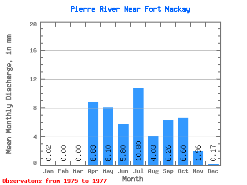
| Statistic | Jan | Feb | Mar | Apr | May | Jun | Jul | Aug | Sep | Oct | Nov | Dec | Annual |
|---|---|---|---|---|---|---|---|---|---|---|---|---|---|
| Mean | 0.01 | 0.00 | 0.00 | 8.82 | 8.10 | 5.79 | 10.80 | 4.02 | 6.26 | 6.60 | 1.95 | 0.17 | |
| Standard Deviation | 0.01 | 0.00 | 0.00 | 5.71 | 0.97 | 4.40 | 0.82 | 6.04 | 0.40 | 1.06 | 0.25 | ||
| Min | 0.00 | 0.00 | 0.00 | 4.78 | 8.10 | 5.10 | 7.69 | 3.44 | 2.72 | 6.31 | 1.01 | 0.00 | |
| Max | 0.02 | 0.00 | 0.00 | 12.86 | 8.10 | 6.47 | 13.91 | 4.59 | 13.23 | 6.88 | 3.10 | 0.46 | |
| Coefficient of Variation | 1.41 | 0.65 | 0.17 | 0.41 | 0.20 | 0.96 | 0.06 | 0.54 | 1.51 |
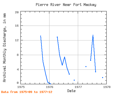
| Year | Jan | Feb | Mar | Apr | May | Jun | Jul | Aug | Sep | Oct | Nov | Dec | Annual | 1975 | 13.23 | 6.31 | 3.10 | 0.46 | 1976 | 0.02 | 0.00 | 0.00 | 12.86 | 8.10 | 5.10 | 7.69 | 4.59 | 2.72 | 1.01 | 0.00 | 1977 | 0.00 | 0.00 | 0.00 | 4.78 | 6.47 | 13.91 | 3.44 | 2.82 | 6.88 | 1.75 | 0.04 |
|---|
 Return to R-Arctic Net Home Page