|
|
|||||||||||||||||
| Point ID: 709 | Downloads | Plots | Site Data | Code: 07DA010 |
|
|
|||||||||||||||||
| Download | |
|---|---|
| Site Descriptor Information | Site Time Series Data |
| Link to all available data | |
|
|
| View: | Statistics | Time Series |
| Units: | m3/s |
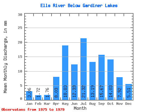
| Statistic | Jan | Feb | Mar | Apr | May | Jun | Jul | Aug | Sep | Oct | Nov | Dec | Annual |
|---|---|---|---|---|---|---|---|---|---|---|---|---|---|
| Mean | 3.06 | 1.74 | 1.76 | 8.03 | 18.83 | 12.33 | 21.32 | 13.19 | 15.67 | 14.03 | 7.92 | 5.51 | 101.29 |
| Standard Deviation | 1.31 | 0.90 | 0.96 | 7.72 | 11.38 | 8.30 | 19.18 | 8.54 | 12.49 | 9.41 | 3.83 | 2.53 | 39.42 |
| Min | 1.66 | 0.81 | 0.41 | 2.65 | 9.31 | 6.24 | 6.42 | 6.54 | 4.88 | 4.85 | 3.51 | 2.81 | 78.03 |
| Max | 4.79 | 2.97 | 2.70 | 16.87 | 31.44 | 21.79 | 49.48 | 25.03 | 32.49 | 25.42 | 12.21 | 7.86 | 146.80 |
| Coefficient of Variation | 0.43 | 0.52 | 0.55 | 0.96 | 0.60 | 0.67 | 0.90 | 0.65 | 0.80 | 0.67 | 0.48 | 0.46 | 0.39 |
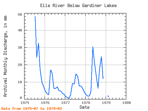
| Year | Jan | Feb | Mar | Apr | May | Jun | Jul | Aug | Sep | Oct | Nov | Dec | Annual | 1975 | 49.48 | 25.03 | 32.49 | 17.87 | 9.75 | 7.86 | 1976 | 4.79 | 2.97 | 2.70 | 16.87 | 15.74 | 6.24 | 6.42 | 7.36 | 4.88 | 4.85 | 3.51 | 2.81 | 79.03 | 1977 | 1.66 | 0.81 | 0.41 | 2.65 | 9.31 | 8.96 | 15.18 | 13.84 | 7.64 | 7.96 | 6.22 | 3.90 | 78.03 | 1978 | 2.64 | 1.61 | 1.93 | 4.56 | 31.44 | 21.79 | 14.19 | 6.54 | 17.67 | 25.42 | 12.21 | 7.45 | 146.80 | 1979 | 3.16 | 1.56 | 2.00 |
|---|
 Return to R-Arctic Net Home Page