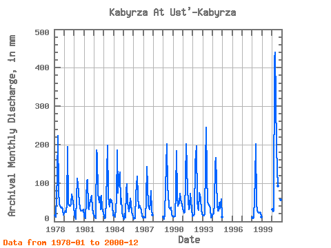
| Point ID: 6905 | Downloads | Plots | Site Data | Code: 10566 |
| Download | |
|---|---|
| Site Descriptor Information | Site Time Series Data |
| Link to all available data | |

|

|
| View: | Statistics | Time Series |
| Units: | m3/s |
| Statistic | Jan | Feb | Mar | Apr | May | Jun | Jul | Aug | Sep | Oct | Nov | Dec | Annual |
|---|---|---|---|---|---|---|---|---|---|---|---|---|---|
| Mean | 16.14 | 13.79 | 16.17 | 117.21 | 194.28 | 75.24 | 52.27 | 48.26 | 48.38 | 54.69 | 33.22 | 20.74 | 688.27 |
| Standard Deviation | 6.63 | 6.01 | 10.53 | 86.49 | 78.08 | 36.60 | 29.24 | 26.41 | 17.83 | 21.24 | 14.94 | 10.93 | 264.79 |
| Min | 6.23 | 6.35 | 5.92 | 45.31 | 100.37 | 36.67 | 26.34 | 24.17 | 22.34 | 24.39 | 10.14 | 10.82 | 451.82 |
| Max | 31.79 | 25.79 | 48.99 | 423.57 | 455.04 | 194.72 | 140.00 | 132.59 | 90.19 | 97.54 | 62.17 | 45.50 | 1674.43 |
| Coefficient of Variation | 0.41 | 0.44 | 0.65 | 0.74 | 0.40 | 0.49 | 0.56 | 0.55 | 0.37 | 0.39 | 0.45 | 0.53 | 0.39 |
| Year | Jan | Feb | Mar | Apr | May | Jun | Jul | Aug | Sep | Oct | Nov | Dec | Annual | 1978 | 14.98 | 15.65 | 11.95 | 120.33 | 230.79 | 78.18 | 47.03 | 42.02 | 35.19 | 37.23 | 29.92 | 18.48 | 679.63 | 1979 | 22.64 | 25.79 | 24.39 | 45.31 | 200.96 | 46.57 | 41.59 | 41.59 | 46.36 | 72.28 | 62.17 | 39.63 | 666.27 | 1980 | 20.10 | 9.36 | 5.92 | 60.69 | 116.26 | 77.34 | 48.99 | 37.88 | 28.03 | 28.52 | 30.14 | 31.57 | 493.22 | 1981 | 13.87 | 10.75 | 7.77 | 106.00 | 112.34 | 36.67 | 31.57 | 48.12 | 59.22 | 68.80 | 33.30 | 23.30 | 550.50 | 1982 | 18.18 | 8.51 | 9.25 | 184.60 | 176.14 | 71.02 | 50.73 | 65.75 | 30.77 | 70.33 | 36.25 | 22.21 | 741.72 | 1983 | 14.98 | 8.09 | 9.38 | 56.05 | 205.31 | 67.64 | 47.90 | 40.50 | 57.74 | 56.83 | 39.83 | 15.81 | 616.94 | 1984 | 17.07 | 14.90 | 12.52 | 57.53 | 191.16 | 74.39 | 110.17 | 132.59 | 45.94 | 61.83 | 24.45 | 13.65 | 750.66 | 1985 | 6.23 | 19.36 | 10.80 | 81.34 | 100.37 | 47.20 | 26.34 | 39.41 | 60.27 | 47.25 | 23.39 | 14.72 | 476.91 | 1986 | 6.97 | 6.96 | 7.55 | 69.96 | 120.62 | 67.22 | 36.80 | 43.55 | 39.41 | 30.26 | 12.98 | 10.82 | 451.82 | 1987 | 10.08 | 10.53 | 9.93 | 56.05 | 148.05 | 91.88 | 42.89 | 32.01 | 50.58 | 83.17 | 27.61 | 18.07 | 578.81 | 1989 | 11.50 | 6.35 | 17.94 | 89.56 | 207.71 | 88.72 | 73.16 | 38.97 | 32.66 | 37.23 | 19.43 | 13.52 | 633.45 | 1990 | 13.19 | 11.59 | 14.33 | 80.29 | 189.20 | 67.43 | 40.93 | 50.51 | 71.86 | 62.70 | 46.99 | 45.50 | 691.88 | 1991 | 27.00 | 20.83 | 24.60 | 111.69 | 208.58 | 80.71 | 56.17 | 33.31 | 37.09 | 74.68 | 33.93 | 13.24 | 719.47 | 1992 | 15.81 | 14.98 | 18.75 | 150.88 | 201.83 | 52.89 | 36.80 | 30.48 | 73.76 | 62.49 | 28.87 | 18.53 | 704.82 | 1993 | 16.31 | 13.98 | 18.90 | 152.99 | 252.56 | 123.07 | 51.38 | 43.55 | 40.25 | 34.62 | 10.14 | 11.56 | 767.49 | 1994 | 20.55 | 19.30 | 48.99 | 150.46 | 171.13 | 42.36 | 29.61 | 28.96 | 49.10 | 34.18 | 59.01 | 11.58 | 664.96 | 1998 | 9.38 | 7.34 | 9.28 | 112.53 | 209.01 | 46.36 | 28.74 | 24.17 | 22.34 | 24.39 | 22.76 | 11.69 | 525.87 | 2000 | 31.79 | 24.00 | 28.74 | 423.57 | 455.04 | 194.72 | 140.00 | 95.36 | 90.19 | 97.54 | 56.90 | 39.41 | 1674.43 |
|---|
 Return to R-Arctic Net Home Page