|
|
|||||||||||||||||
| Point ID: 6796 | Downloads | Plots | Site Data | Code: 10338 |
|
|
|||||||||||||||||
| Download | |
|---|---|
| Site Descriptor Information | Site Time Series Data |
| Link to all available data | |
|
|
| View: | Statistics | Time Series |
| Units: | m3/s |
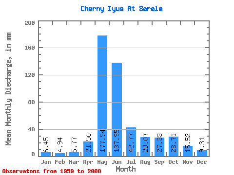
| Statistic | Jan | Feb | Mar | Apr | May | Jun | Jul | Aug | Sep | Oct | Nov | Dec | Annual |
|---|---|---|---|---|---|---|---|---|---|---|---|---|---|
| Mean | 6.45 | 4.98 | 5.77 | 21.56 | 177.91 | 137.96 | 42.77 | 28.06 | 27.33 | 28.71 | 15.52 | 9.31 | 504.32 |
| Standard Deviation | 1.26 | 1.24 | 1.03 | 11.14 | 39.97 | 63.28 | 18.45 | 9.76 | 11.57 | 11.73 | 6.58 | 2.47 | 89.48 |
| Min | 3.85 | 2.02 | 4.19 | 7.79 | 114.89 | 43.73 | 17.45 | 13.91 | 11.29 | 11.49 | 7.83 | 5.27 | 312.61 |
| Max | 8.98 | 7.42 | 8.55 | 49.58 | 266.94 | 271.74 | 120.94 | 49.07 | 57.19 | 61.25 | 40.80 | 18.83 | 691.50 |
| Coefficient of Variation | 0.20 | 0.25 | 0.18 | 0.52 | 0.23 | 0.46 | 0.43 | 0.35 | 0.42 | 0.41 | 0.42 | 0.27 | 0.18 |
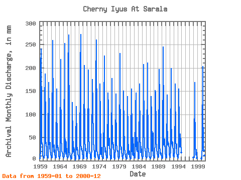
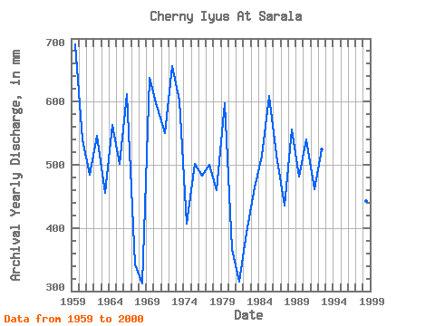
| Year | Jan | Feb | Mar | Apr | May | Jun | Jul | Aug | Sep | Oct | Nov | Dec | Annual | 1959 | 4.86 | 4.67 | 5.01 | 25.67 | 209.06 | 239.97 | 78.18 | 38.27 | 37.96 | 30.15 | 11.12 | 8.29 | 691.50 | 1960 | 6.27 | 5.68 | 5.62 | 14.88 | 133.04 | 186.46 | 68.85 | 38.53 | 38.71 | 23.24 | 11.37 | 9.42 | 541.08 | 1961 | 5.75 | 5.43 | 5.88 | 36.37 | 173.64 | 99.50 | 45.27 | 26.26 | 39.05 | 25.31 | 12.29 | 11.32 | 483.97 | 1962 | 7.84 | 5.53 | 7.35 | 33.19 | 266.94 | 95.32 | 38.18 | 20.47 | 17.73 | 34.81 | 13.38 | 8.98 | 545.61 | 1963 | 6.66 | 5.83 | 7.02 | 9.95 | 158.95 | 127.93 | 33.86 | 23.50 | 33.11 | 25.23 | 15.97 | 9.42 | 455.87 | 1964 | 7.33 | 4.05 | 6.00 | 12.38 | 224.61 | 173.91 | 46.13 | 31.45 | 19.90 | 17.88 | 13.38 | 9.76 | 564.16 | 1965 | 6.72 | 5.42 | 6.35 | 10.87 | 260.02 | 72.07 | 22.29 | 14.86 | 42.48 | 40.52 | 13.38 | 10.71 | 501.66 | 1966 | 6.28 | 5.71 | 6.20 | 8.04 | 199.55 | 270.91 | 55.89 | 21.86 | 12.54 | 11.49 | 9.53 | 5.27 | 612.65 | 1967 | 3.85 | 3.51 | 4.81 | 25.00 | 129.58 | 46.49 | 38.10 | 19.09 | 28.26 | 23.41 | 13.71 | 8.15 | 341.83 | 1968 | 5.14 | 2.02 | 5.28 | 31.94 | 120.94 | 43.73 | 24.10 | 29.11 | 18.06 | 14.95 | 10.87 | 8.51 | 312.61 | 1969 | 5.36 | 3.81 | 4.87 | 11.29 | 202.15 | 271.74 | 38.70 | 26.26 | 21.41 | 26.78 | 17.31 | 8.64 | 637.72 | 1970 | 5.51 | 5.28 | 4.89 | 37.21 | 211.65 | 185.62 | 38.70 | 35.51 | 22.24 | 27.04 | 13.46 | 8.98 | 594.34 | 1971 | 7.04 | 5.53 | 4.95 | 26.92 | 202.15 | 166.39 | 59.69 | 23.93 | 20.32 | 17.97 | 11.54 | 6.66 | 551.04 | 1972 | 5.53 | 4.24 | 5.40 | 31.77 | 173.64 | 174.75 | 120.94 | 46.39 | 40.13 | 29.29 | 16.30 | 10.80 | 656.34 | 1973 | 7.26 | 5.42 | 7.01 | 33.53 | 174.50 | 259.20 | 50.19 | 26.09 | 12.04 | 12.61 | 8.86 | 5.90 | 602.56 | 1974 | 4.86 | 3.14 | 4.24 | 24.25 | 170.18 | 90.30 | 26.09 | 14.34 | 24.75 | 29.46 | 10.37 | 7.60 | 407.42 | 1975 | 6.24 | 4.45 | 5.53 | 8.02 | 114.89 | 225.75 | 41.47 | 19.95 | 24.58 | 27.82 | 14.88 | 8.52 | 502.43 | 1976 | 6.28 | 5.30 | 5.67 | 10.79 | 150.31 | 117.06 | 34.38 | 45.18 | 48.16 | 38.87 | 14.55 | 8.04 | 482.62 | 1977 | 5.09 | 3.80 | 4.76 | 29.85 | 183.14 | 108.70 | 43.80 | 28.51 | 39.72 | 32.48 | 14.88 | 8.55 | 500.91 | 1978 | 5.35 | 3.26 | 4.33 | 32.19 | 148.59 | 127.09 | 36.20 | 29.03 | 23.91 | 20.56 | 21.24 | 9.76 | 460.20 | 1979 | 6.10 | 5.04 | 5.55 | 8.95 | 238.43 | 183.11 | 39.31 | 24.62 | 29.93 | 28.25 | 21.15 | 10.28 | 598.36 | 1980 | 7.13 | 4.30 | 5.16 | 18.90 | 154.63 | 65.22 | 40.17 | 30.06 | 15.89 | 12.70 | 8.78 | 6.66 | 366.92 | 1981 | 5.13 | 3.98 | 4.91 | 26.92 | 142.54 | 53.60 | 17.45 | 13.91 | 13.29 | 21.25 | 7.83 | 6.60 | 315.40 | 1982 | 4.84 | 3.25 | 4.63 | 39.80 | 158.95 | 47.33 | 26.61 | 14.34 | 11.29 | 52.18 | 22.32 | 9.68 | 392.37 | 1983 | 6.35 | 5.92 | 6.09 | 7.79 | 117.49 | 145.49 | 36.28 | 24.53 | 19.90 | 52.18 | 32.02 | 11.84 | 464.78 | 1984 | 7.40 | 4.27 | 5.37 | 12.96 | 158.95 | 164.72 | 51.83 | 29.03 | 17.89 | 31.36 | 21.49 | 11.58 | 515.06 | 1985 | 7.99 | 6.38 | 5.24 | 12.12 | 189.19 | 207.36 | 53.04 | 49.07 | 31.02 | 23.67 | 16.55 | 9.24 | 609.24 | 1986 | 7.26 | 6.09 | 6.32 | 9.37 | 216.83 | 163.04 | 33.17 | 23.24 | 19.98 | 17.19 | 8.70 | 7.12 | 516.17 | 1987 | 5.48 | 4.66 | 4.84 | 9.03 | 142.54 | 94.48 | 33.00 | 21.51 | 40.72 | 61.25 | 11.46 | 9.59 | 436.21 | 1988 | 7.95 | 5.49 | 6.30 | 49.58 | 156.36 | 144.65 | 68.94 | 47.95 | 23.50 | 18.83 | 16.14 | 12.09 | 555.92 | 1989 | 7.71 | 6.66 | 7.78 | 21.57 | 203.01 | 132.11 | 34.81 | 17.71 | 13.21 | 17.80 | 13.38 | 8.07 | 481.65 | 1990 | 6.15 | 4.82 | 5.83 | 15.22 | 252.25 | 78.60 | 35.25 | 40.86 | 31.10 | 48.29 | 16.39 | 10.63 | 540.67 | 1991 | 8.81 | 6.82 | 6.62 | 16.55 | 145.99 | 92.81 | 34.81 | 36.45 | 40.47 | 34.55 | 26.59 | 13.56 | 462.14 | 1992 | 8.98 | 7.13 | 6.94 | 24.41 | 204.74 | 96.16 | 39.56 | 32.91 | 41.47 | 38.36 | 15.30 | 11.84 | 524.80 | 1993 | 8.81 | 7.42 | 8.55 | 23.08 | 128.72 | 164.72 | 47.60 | 27.73 | 31.27 | 37.41 | 17.89 | 9.59 | 512.03 | 1994 | 7.07 | 5.29 | 6.53 | 18.48 | 159.82 | 77.68 | 30.15 | 36.45 | 57.19 | 40.34 | 40.80 | 18.83 | 496.53 | 1998 | 7.45 | 6.43 | 7.20 | 12.29 | 173.64 | 132.11 | 35.07 | 15.12 | 12.12 | 25.14 | 12.88 | 6.03 | 443.62 | 2000 | 5.08 | 3.18 | 4.19 | 38.30 | 209.06 | 116.22 | 27.13 | 22.29 | 23.24 | 20.39 | 11.54 | 7.29 | 485.62 |
|---|
 Return to R-Arctic Net Home Page