|
|
|||||||||||||||||
| Point ID: 6714 | Downloads | Plots | Site Data | Other Close Sites | Code: 10133 |
|
|
|||||||||||||||||
| Download | |
|---|---|
| Site Descriptor Information | Site Time Series Data |
| Link to all available data | |
|
|
| View: | Statistics | Time Series |
| Units: | m3/s |
| Statistic | Jan | Feb | Mar | Apr | May | Jun | Jul | Aug | Sep | Oct | Nov | Dec | Annual |
|---|---|---|---|---|---|---|---|---|---|---|---|---|---|
| Mean | 4.46 | 3.44 | 5.01 | 47.88 | 76.81 | 52.29 | 24.63 | 17.28 | 13.19 | 16.96 | 10.84 | 5.65 | 277.81 |
| Standard Deviation | 0.86 | 0.71 | 1.76 | 15.56 | 15.68 | 21.82 | 9.20 | 8.74 | 5.11 | 7.44 | 5.10 | 2.00 | 53.98 |
| Min | 2.69 | 2.11 | 2.45 | 25.79 | 47.00 | 22.03 | 11.25 | 7.27 | 6.44 | 7.00 | 3.85 | 2.96 | 186.61 |
| Max | 6.44 | 4.83 | 9.12 | 87.87 | 106.99 | 102.90 | 43.92 | 41.51 | 31.88 | 34.68 | 25.92 | 9.96 | 404.15 |
| Coefficient of Variation | 0.19 | 0.21 | 0.35 | 0.33 | 0.20 | 0.42 | 0.37 | 0.51 | 0.39 | 0.44 | 0.47 | 0.35 | 0.19 |
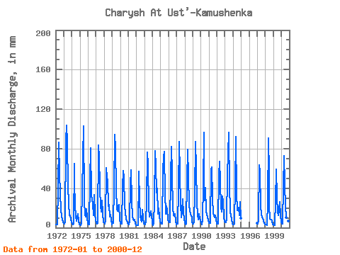
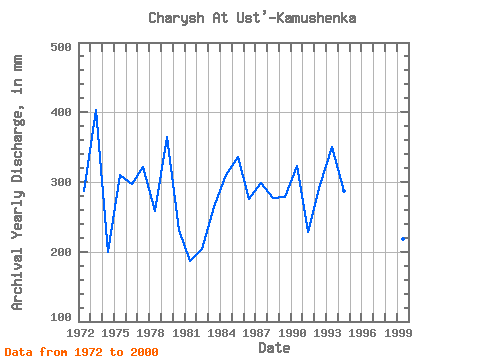
| Year | Jan | Feb | Mar | Apr | May | Jun | Jul | Aug | Sep | Oct | Nov | Dec | Annual | 1972 | 3.50 | 3.01 | 3.28 | 41.47 | 89.58 | 54.43 | 37.09 | 16.47 | 13.74 | 11.73 | 9.29 | 5.30 | 287.88 | 1973 | 4.70 | 3.95 | 5.88 | 87.87 | 106.99 | 86.18 | 43.92 | 25.44 | 12.62 | 12.91 | 8.98 | 5.21 | 404.15 | 1974 | 4.10 | 3.37 | 4.08 | 64.80 | 47.00 | 22.81 | 11.25 | 7.27 | 10.37 | 14.19 | 6.73 | 3.48 | 199.60 | 1975 | 3.33 | 2.70 | 4.61 | 37.45 | 73.38 | 102.90 | 28.25 | 13.14 | 10.86 | 19.28 | 10.43 | 4.23 | 310.52 | 1976 | 4.38 | 3.25 | 3.23 | 48.21 | 83.02 | 33.57 | 28.92 | 25.44 | 12.56 | 34.68 | 13.74 | 7.61 | 297.07 | 1977 | 5.05 | 3.85 | 5.12 | 83.59 | 73.64 | 42.25 | 20.35 | 23.43 | 15.81 | 28.39 | 14.77 | 5.42 | 321.39 | 1978 | 5.21 | 3.45 | 6.82 | 60.39 | 51.95 | 48.47 | 22.76 | 24.24 | 11.17 | 13.66 | 7.49 | 3.25 | 258.71 | 1979 | 6.44 | 4.23 | 5.44 | 40.18 | 97.21 | 80.87 | 41.24 | 19.28 | 16.72 | 22.63 | 23.33 | 8.06 | 364.73 | 1980 | 4.75 | 3.46 | 4.39 | 41.08 | 59.59 | 51.32 | 22.90 | 15.67 | 8.55 | 8.13 | 7.88 | 4.55 | 231.99 | 1981 | 4.00 | 2.77 | 6.31 | 43.29 | 60.52 | 27.22 | 11.66 | 8.48 | 7.41 | 8.57 | 3.85 | 2.96 | 186.61 | 1982 | 2.69 | 2.12 | 2.45 | 49.90 | 58.65 | 27.73 | 11.92 | 8.40 | 6.44 | 19.15 | 10.12 | 4.33 | 203.51 | 1983 | 3.79 | 3.32 | 6.56 | 26.57 | 78.73 | 63.37 | 21.29 | 11.52 | 13.61 | 17.68 | 11.76 | 6.20 | 263.72 | 1984 | 4.35 | 2.11 | 4.06 | 27.61 | 80.61 | 62.60 | 36.42 | 41.38 | 13.74 | 20.49 | 11.96 | 6.03 | 309.74 | 1985 | 4.75 | 3.89 | 3.74 | 58.71 | 73.78 | 77.37 | 33.07 | 18.34 | 13.74 | 22.90 | 18.14 | 8.28 | 336.52 | 1986 | 6.16 | 4.77 | 5.20 | 50.54 | 85.03 | 55.08 | 20.62 | 12.71 | 11.74 | 14.60 | 6.79 | 3.59 | 276.36 | 1987 | 4.14 | 3.81 | 4.02 | 38.75 | 89.98 | 55.21 | 24.10 | 10.82 | 15.94 | 29.73 | 13.87 | 9.96 | 299.33 | 1988 | 5.06 | 3.23 | 4.18 | 48.60 | 82.08 | 52.62 | 23.30 | 18.08 | 13.48 | 11.90 | 10.26 | 5.65 | 277.83 | 1989 | 4.45 | 3.82 | 6.40 | 35.12 | 89.85 | 60.91 | 25.57 | 13.52 | 7.93 | 14.60 | 8.96 | 7.95 | 278.12 | 1990 | 4.94 | 3.15 | 8.62 | 42.38 | 99.35 | 47.56 | 28.25 | 41.51 | 17.11 | 13.20 | 11.21 | 8.02 | 323.63 | 1991 | 5.06 | 4.17 | 4.66 | 58.71 | 63.60 | 29.42 | 15.13 | 12.35 | 10.55 | 12.60 | 7.92 | 4.25 | 228.19 | 1992 | 4.12 | 4.09 | 3.79 | 53.14 | 69.09 | 46.79 | 21.42 | 16.34 | 31.88 | 27.32 | 11.05 | 6.60 | 295.38 | 1993 | 5.74 | 4.83 | 9.12 | 54.43 | 77.53 | 96.68 | 40.57 | 20.75 | 14.52 | 13.93 | 8.05 | 4.07 | 350.07 | 1994 | 3.63 | 2.71 | 3.99 | 42.51 | 94.94 | 34.60 | 18.08 | 18.34 | 20.74 | 12.94 | 25.92 | 9.69 | 287.21 | 1997 | 4.63 | 3.81 | 7.56 | 63.37 | 57.84 | 22.03 | 13.93 | 10.74 | 9.84 | 7.00 | 4.55 | 3.46 | 208.64 | 1998 | 3.54 | 2.76 | 2.73 | 25.79 | 93.86 | 55.47 | 23.30 | 9.37 | 7.94 | 8.44 | 6.78 | 3.70 | 242.70 | 1999 | 3.52 | 2.54 | 2.58 | 26.70 | 60.79 | 30.59 | 16.74 | 12.95 | 17.63 | 27.32 | 12.25 | 5.61 | 218.36 | 2000 | 4.29 | 3.66 | 6.47 | 41.47 | 75.25 | 43.80 | 22.90 | 10.64 | 9.53 | 9.99 | 6.54 | 5.10 | 239.00 |
|---|
| Other Close Sites | ||||||
|---|---|---|---|---|---|---|
| PointID | Latitude | Longitude | Drainage Area | Source | Name | |
| 6715 | "Charysh At Charishskiy Zernovoy Sovkhoz" | 52.13 | -483851 | SHI | 82.00 | |
 Return to R-Arctic Net Home Page
