|
|
|||||||||||||||||
| Point ID: 6701 | Downloads | Plots | Site Data | Code: 10110 |
|
|
|||||||||||||||||
| Download | |
|---|---|
| Site Descriptor Information | Site Time Series Data |
| Link to all available data | |
|
|
| View: | Statistics | Time Series |
| Units: | m3/s |
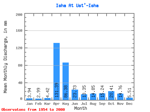
| Statistic | Jan | Feb | Mar | Apr | May | Jun | Jul | Aug | Sep | Oct | Nov | Dec | Annual |
|---|---|---|---|---|---|---|---|---|---|---|---|---|---|
| Mean | 3.94 | 3.02 | 4.42 | 131.39 | 86.37 | 23.73 | 13.35 | 14.85 | 15.24 | 20.41 | 14.76 | 5.51 | 335.73 |
| Standard Deviation | 1.50 | 0.99 | 2.17 | 36.63 | 65.90 | 15.29 | 11.78 | 16.81 | 13.74 | 16.90 | 12.23 | 2.80 | 91.22 |
| Min | 1.59 | 1.46 | 1.94 | 39.19 | 24.31 | 4.37 | 3.18 | 2.22 | 2.79 | 3.56 | 2.70 | 2.19 | 206.06 |
| Max | 9.64 | 6.62 | 12.91 | 203.66 | 341.13 | 70.74 | 68.15 | 76.36 | 50.76 | 82.09 | 77.91 | 13.31 | 606.83 |
| Coefficient of Variation | 0.38 | 0.33 | 0.49 | 0.28 | 0.76 | 0.64 | 0.88 | 1.13 | 0.90 | 0.83 | 0.83 | 0.51 | 0.27 |
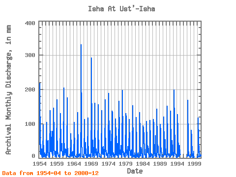
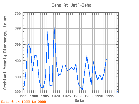
| Year | Jan | Feb | Mar | Apr | May | Jun | Jul | Aug | Sep | Oct | Nov | Dec | Annual | 1954 | 39.19 | 223.96 | 24.30 | 13.15 | 11.64 | 39.03 | 9.48 | 27.08 | 6.97 | 1955 | 2.14 | 1.92 | 3.45 | 97.20 | 70.38 | 4.37 | 3.83 | 3.40 | 10.57 | 15.86 | 6.27 | 4.79 | 224.20 | 1956 | 1.59 | 1.46 | 1.94 | 103.37 | 53.08 | 49.53 | 8.29 | 28.53 | 50.68 | 16.34 | 15.04 | 4.50 | 335.62 | 1957 | 2.93 | 2.46 | 3.65 | 138.09 | 122.74 | 39.81 | 20.72 | 22.08 | 17.90 | 45.03 | 77.91 | 13.31 | 506.70 | 1958 | 9.64 | 6.62 | 8.05 | 145.03 | 142.67 | 70.74 | 30.68 | 14.11 | 5.58 | 18.81 | 19.67 | 4.48 | 476.05 | 1959 | 3.57 | 3.56 | 4.19 | 170.49 | 87.67 | 13.42 | 20.64 | 11.96 | 5.52 | 5.26 | 6.80 | 4.68 | 338.45 | 1960 | 4.17 | 3.42 | 4.18 | 109.54 | 134.70 | 38.42 | 21.04 | 25.03 | 42.97 | 22.71 | 18.05 | 8.53 | 432.13 | 1961 | 6.29 | 5.71 | 6.66 | 203.66 | 45.83 | 42.20 | 10.12 | 18.25 | 26.61 | 25.66 | 24.99 | 11.72 | 430.29 | 1962 | 6.16 | 4.36 | 12.91 | 175.89 | 34.51 | 22.22 | 4.58 | 3.48 | 3.52 | 5.12 | 3.30 | 3.28 | 281.42 | 1963 | 3.30 | 2.96 | 5.32 | 53.77 | 72.61 | 33.94 | 6.77 | 5.40 | 6.81 | 14.66 | 19.52 | 7.30 | 232.18 | 1964 | 4.31 | 2.02 | 2.21 | 76.83 | 107.60 | 12.34 | 9.48 | 3.61 | 3.42 | 4.05 | 5.30 | 4.66 | 235.00 | 1965 | 3.88 | 2.27 | 2.57 | 101.83 | 136.29 | 5.53 | 3.88 | 3.89 | 7.87 | 9.80 | 11.80 | 6.79 | 295.45 | 1966 | 4.83 | 3.35 | 3.24 | 144.26 | 341.13 | 49.29 | 13.55 | 5.27 | 3.64 | 4.94 | 4.91 | 3.86 | 578.73 | 1967 | 2.77 | 2.33 | 2.61 | 111.86 | 25.66 | 16.66 | 7.79 | 46.63 | 8.87 | 14.74 | 5.06 | 2.29 | 247.71 | 1968 | 2.51 | 2.09 | 8.53 | 117.26 | 66.31 | 5.43 | 4.76 | 7.24 | 5.44 | 8.05 | 10.18 | 6.03 | 244.17 | 1969 | 4.66 | 2.80 | 3.20 | 156.60 | 302.07 | 24.45 | 4.77 | 3.88 | 39.57 | 53.48 | 10.03 | 4.45 | 606.83 | 1970 | 3.81 | 3.54 | 3.02 | 160.46 | 101.22 | 20.06 | 9.09 | 8.85 | 24.45 | 28.05 | 10.49 | 5.03 | 378.66 | 1971 | 3.69 | 3.33 | 3.52 | 155.83 | 91.66 | 16.51 | 11.96 | 5.41 | 5.10 | 4.42 | 4.11 | 2.61 | 308.86 | 1972 | 2.74 | 2.39 | 3.27 | 138.09 | 50.93 | 13.96 | 18.49 | 10.76 | 11.03 | 34.75 | 18.51 | 12.91 | 318.29 | 1973 | 6.03 | 3.38 | 4.19 | 169.71 | 102.02 | 18.90 | 23.03 | 9.80 | 7.71 | 15.38 | 10.03 | 2.19 | 372.76 | 1974 | 3.65 | 2.35 | 3.04 | 189.00 | 30.68 | 21.52 | 3.18 | 2.22 | 12.73 | 82.09 | 16.66 | 4.49 | 373.01 | 1975 | 3.19 | 3.12 | 3.90 | 137.31 | 136.29 | 15.04 | 4.61 | 4.36 | 6.46 | 15.30 | 6.22 | 3.04 | 338.45 | 1976 | 3.40 | 2.92 | 3.17 | 113.40 | 64.00 | 9.10 | 13.63 | 66.07 | 7.87 | 44.39 | 11.96 | 5.55 | 344.20 | 1977 | 3.62 | 2.58 | 3.83 | 165.09 | 74.76 | 13.04 | 9.17 | 13.63 | 11.80 | 38.42 | 16.05 | 4.26 | 356.81 | 1978 | 3.71 | 3.02 | 4.49 | 197.49 | 46.39 | 21.06 | 10.04 | 20.48 | 5.73 | 15.54 | 9.33 | 4.25 | 343.31 | 1979 | 3.29 | 3.14 | 4.18 | 130.37 | 121.15 | 22.91 | 6.47 | 6.28 | 13.65 | 34.67 | 23.14 | 9.01 | 377.99 | 1980 | 4.97 | 2.54 | 2.66 | 111.86 | 36.19 | 29.31 | 12.59 | 8.69 | 7.71 | 13.87 | 23.53 | 5.55 | 260.68 | 1981 | 3.04 | 2.05 | 4.07 | 152.74 | 24.31 | 4.74 | 3.50 | 5.30 | 4.10 | 13.47 | 14.89 | 2.58 | 236.53 | 1982 | 2.07 | 1.94 | 2.49 | 118.80 | 32.76 | 18.82 | 5.91 | 5.48 | 3.77 | 15.38 | 10.03 | 2.93 | 221.55 | 1983 | 2.66 | 2.19 | 7.12 | 131.91 | 72.61 | 19.13 | 7.21 | 7.29 | 31.09 | 22.88 | 19.36 | 5.56 | 329.88 | 1984 | 3.04 | 2.25 | 2.77 | 94.11 | 88.47 | 42.27 | 68.15 | 76.36 | 8.72 | 25.66 | 15.97 | 5.21 | 430.67 | 1985 | 3.43 | 2.69 | 2.57 | 106.46 | 45.11 | 58.40 | 16.34 | 27.26 | 33.48 | 23.99 | 16.74 | 6.22 | 343.80 | 1986 | 4.42 | 2.72 | 3.28 | 109.54 | 51.25 | 25.69 | 4.42 | 10.28 | 12.19 | 11.72 | 9.33 | 3.63 | 249.37 | 1987 | 2.53 | 2.66 | 3.07 | 112.63 | 100.42 | 40.81 | 17.30 | 7.01 | 15.74 | 67.19 | 20.52 | 6.01 | 395.22 | 1988 | 5.46 | 4.12 | 3.82 | 142.71 | 45.35 | 16.51 | 39.77 | 30.53 | 10.80 | 11.24 | 7.64 | 3.83 | 322.21 | 1989 | 3.00 | 1.96 | 8.21 | 97.97 | 77.23 | 32.86 | 28.37 | 6.22 | 4.07 | 6.74 | 7.18 | 6.34 | 279.96 | 1990 | 3.52 | 3.01 | 6.46 | 119.57 | 35.95 | 9.26 | 9.17 | 55.95 | 41.27 | 12.19 | 11.19 | 5.49 | 313.61 | 1991 | 4.34 | 3.12 | 3.91 | 151.20 | 51.73 | 13.73 | 13.23 | 7.09 | 7.00 | 12.35 | 8.18 | 3.63 | 280.69 | 1992 | 3.40 | 3.17 | 3.51 | 137.31 | 33.40 | 16.12 | 8.45 | 9.64 | 50.76 | 27.98 | 21.83 | 10.52 | 327.91 | 1993 | 6.78 | 4.50 | 6.35 | 199.03 | 96.44 | 40.89 | 14.03 | 10.76 | 10.41 | 10.44 | 4.47 | 2.77 | 408.31 | 1994 | 3.11 | 2.63 | 4.44 | 126.51 | 78.59 | 12.57 | 4.65 | 5.61 | 21.75 | 13.55 | 36.03 | 10.84 | 321.20 | 1997 | 6.23 | 4.12 | 7.75 | 168.94 | 32.52 | 6.24 | 8.13 | 6.72 | 5.92 | 3.56 | 2.70 | 2.72 | 257.36 | 1998 | 3.32 | 3.73 | 4.22 | 81.00 | 60.49 | 10.80 | 6.25 | 4.91 | 2.79 | 5.59 | 19.44 | 3.15 | 206.06 | 2000 | 4.33 | 3.36 | 4.03 | 117.26 | 51.09 | 21.29 | 26.06 | 5.91 | 14.35 | 13.15 | 8.02 | 4.40 | 273.91 |
|---|
 Return to R-Arctic Net Home Page