|
|
|||||||||||||||||
| Point ID: 6691 | Downloads | Plots | Site Data | Code: 10081 |
|
|
|||||||||||||||||
| Download | |
|---|---|
| Site Descriptor Information | Site Time Series Data |
| Link to all available data | |
|
|
| View: | Statistics | Time Series |
| Units: | m3/s |
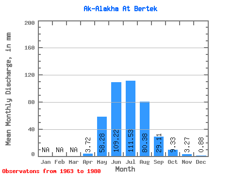
| Statistic | Jan | Feb | Mar | Apr | May | Jun | Jul | Aug | Sep | Oct | Nov | Dec | Annual |
|---|---|---|---|---|---|---|---|---|---|---|---|---|---|
| Mean | 3.72 | 58.27 | 109.22 | 111.51 | 80.37 | 29.11 | 9.33 | 3.27 | 0.88 | ||||
| Standard Deviation | 5.21 | 28.06 | 33.87 | 14.55 | 11.36 | 8.83 | 4.79 | 0.91 | 0.62 | ||||
| Min | 0.06 | 25.58 | 78.79 | 84.52 | 66.28 | 15.89 | 0.67 | 1.98 | 0.09 | ||||
| Max | 14.34 | 111.21 | 177.82 | 126.34 | 100.09 | 43.49 | 15.66 | 4.39 | 1.78 | ||||
| Coefficient of Variation | 1.40 | 0.48 | 0.31 | 0.13 | 0.14 | 0.30 | 0.51 | 0.28 | 0.71 |
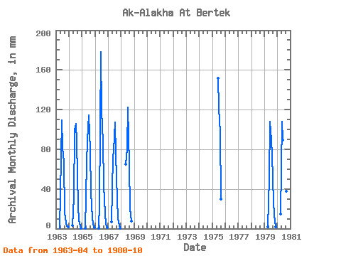
| Year | Jan | Feb | Mar | Apr | May | Jun | Jul | Aug | Sep | Oct | Nov | Dec | Annual | 1963 | 0.06 | 35.85 | 109.36 | 84.52 | 69.40 | 15.89 | 6.14 | 2.71 | 1.78 | 1964 | 2.93 | 32.43 | 99.03 | 109.43 | 90.31 | 22.26 | 8.23 | 2.97 | 0.62 | 1965 | 0.07 | 67.62 | 88.27 | 117.89 | 81.85 | 36.04 | 10.72 | 4.39 | 1.11 | 1966 | 0.30 | 25.58 | 177.82 | 122.33 | 90.75 | 43.49 | 15.66 | 4.13 | 0.80 | 1967 | 6.50 | 74.73 | 78.79 | 110.77 | 77.40 | 29.71 | 10.94 | 3.44 | 0.09 | 1968 | 66.73 | 80.52 | 126.34 | 66.28 | 20.50 | 7.74 | 1975 | 151.56 | 125.45 | 100.09 | 29.97 | 1979 | 1.85 | 52.05 | 108.07 | 92.08 | 76.51 | 26.87 | 14.55 | 1.98 | 1980 | 14.34 | 111.21 | 89.56 | 114.77 | 70.73 | 37.29 | 0.67 |
|---|
 Return to R-Arctic Net Home Page