|
|
|||||||||||||||||
| Point ID: 6682 | Downloads | Plots | Site Data | Code: 10066 |
|
|
|||||||||||||||||
| Download | |
|---|---|
| Site Descriptor Information | Site Time Series Data |
| Link to all available data | |
|
|
| View: | Statistics | Time Series |
| Units: | m3/s |
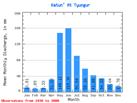
| Statistic | Jan | Feb | Mar | Apr | May | Jun | Jul | Aug | Sep | Oct | Nov | Dec | Annual |
|---|---|---|---|---|---|---|---|---|---|---|---|---|---|
| Mean | 10.81 | 7.96 | 9.33 | 31.02 | 148.10 | 159.90 | 90.53 | 58.15 | 41.88 | 34.32 | 20.05 | 13.78 | 599.40 |
| Standard Deviation | 2.61 | 2.29 | 2.25 | 13.89 | 30.94 | 55.58 | 34.88 | 21.96 | 18.23 | 15.04 | 5.42 | 3.42 | 128.99 |
| Min | 5.43 | 3.42 | 4.36 | 13.59 | 52.17 | 57.60 | 39.28 | 28.76 | 1.72 | 17.81 | 11.87 | 8.43 | 383.22 |
| Max | 17.22 | 12.05 | 13.45 | 89.66 | 210.27 | 280.32 | 202.34 | 122.99 | 116.35 | 103.75 | 34.37 | 22.02 | 928.74 |
| Coefficient of Variation | 0.24 | 0.29 | 0.24 | 0.45 | 0.21 | 0.35 | 0.39 | 0.38 | 0.43 | 0.44 | 0.27 | 0.25 | 0.21 |
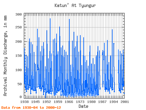
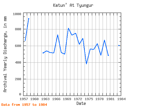
| Year | Jan | Feb | Mar | Apr | May | Jun | Jul | Aug | Sep | Oct | Nov | Dec | Annual | 1938 | 50.88 | 181.51 | 133.82 | 116.44 | 62.69 | 46.66 | 38.88 | 1939 | 32.06 | 156.71 | 111.17 | 113.07 | 42.05 | 24.00 | 1940 | 33.02 | 129.73 | 147.26 | 65.86 | 48.01 | 49.34 | 32.53 | 1941 | 36.86 | 191.82 | 209.28 | 105.73 | 67.84 | 65.09 | 46.22 | 1942 | 16.78 | 124.18 | 195.84 | 100.97 | 65.66 | 34.18 | 32.73 | 1943 | 35.14 | 156.51 | 188.35 | 88.87 | 51.38 | 29.18 | 1944 | 27.84 | 131.32 | 161.66 | 90.06 | 42.45 | 36.67 | 27.97 | 1945 | 27.84 | 124.38 | 67.58 | 52.37 | 39.48 | 21.50 | 19.84 | 1946 | 39.36 | 127.75 | 243.84 | 125.17 | 118.03 | 116.35 | 103.75 | 1947 | 41.09 | 155.13 | 213.12 | 128.35 | 87.08 | 57.60 | 36.70 | 1948 | 34.18 | 139.85 | 163.97 | 102.56 | 47.61 | 30.91 | 27.57 | 1949 | 33.22 | 149.37 | 183.36 | 118.23 | 50.78 | 40.70 | 1950 | 13.59 | 202.34 | 152.26 | 67.84 | 53.16 | 37.82 | 23.61 | 1951 | 30.14 | 114.86 | 57.60 | 39.87 | 30.15 | 1.72 | 19.58 | 1952 | 21.12 | 189.44 | 238.08 | 149.37 | 65.26 | 33.41 | 23.41 | 1953 | 17.89 | 144.41 | 129.79 | 54.75 | 35.71 | 24.58 | 21.42 | 1954 | 16.34 | 52.17 | 280.32 | 154.33 | 65.66 | 50.50 | 25.19 | 1955 | 15.15 | 161.67 | 102.53 | 43.44 | 35.51 | 43.58 | 25.99 | 1956 | 168.22 | 205.44 | 102.76 | 47.61 | 48.00 | 33.72 | 19.12 | 10.93 | 1957 | 12.12 | 9.05 | 11.96 | 16.49 | 99.78 | 209.28 | 92.24 | 97.00 | 39.74 | 34.52 | 24.19 | 17.14 | 661.94 | 1958 | 13.21 | 11.19 | 11.66 | 26.11 | 166.83 | 226.56 | 202.34 | 112.67 | 67.58 | 45.62 | 27.26 | 22.02 | 928.74 | 1959 | 27.84 | 153.14 | 163.97 | 90.46 | 64.87 | 38.59 | 26.58 | 1960 | 27.84 | 93.43 | 251.52 | 190.24 | 122.99 | 59.71 | 32.53 | 1961 | 12.10 | 76.22 | 154.33 | 178.18 | 127.95 | 108.51 | 70.27 | 39.48 | 23.04 | 1962 | 11.15 | 10.30 | 13.45 | 29.95 | 190.04 | 111.94 | 46.62 | 35.51 | 22.27 | 22.02 | 13.82 | 8.43 | 513.04 | 1963 | 9.19 | 11.77 | 12.14 | 14.25 | 121.80 | 169.15 | 66.26 | 47.01 | 31.68 | 28.17 | 20.16 | 10.71 | 541.35 | 1964 | 10.51 | 6.65 | 8.87 | 16.63 | 120.21 | 162.43 | 78.95 | 51.18 | 25.34 | 17.81 | 13.00 | 8.61 | 518.60 | 1965 | 5.43 | 4.70 | 6.19 | 22.08 | 155.92 | 87.36 | 47.01 | 45.62 | 57.60 | 47.01 | 24.19 | 14.86 | 515.38 | 1966 | 11.53 | 9.85 | 10.08 | 22.27 | 127.55 | 278.40 | 144.61 | 57.73 | 28.99 | 19.84 | 13.13 | 11.72 | 734.63 | 1967 | 9.92 | 6.22 | 6.11 | 33.41 | 120.21 | 67.39 | 81.33 | 77.56 | 56.26 | 36.90 | 16.84 | 10.31 | 519.36 | 1968 | 8.07 | 5.91 | 6.82 | 36.67 | 208.29 | 75.84 | 68.83 | 28.76 | 20.35 | 18.53 | 12.35 | 12.02 | 498.75 | 1969 | 9.11 | 4.97 | 4.36 | 23.42 | 200.35 | 232.32 | 124.38 | 51.18 | 70.85 | 55.54 | 23.81 | 14.74 | 812.32 | 1970 | 8.07 | 6.56 | 9.66 | 35.33 | 158.90 | 181.06 | 106.92 | 74.59 | 59.14 | 50.78 | 23.23 | 19.56 | 731.00 | 1971 | 11.25 | 6.71 | 8.03 | 36.10 | 186.87 | 218.88 | 132.31 | 70.82 | 33.41 | 23.61 | 13.17 | 13.61 | 751.69 | 1972 | 14.22 | 8.01 | 10.51 | 26.50 | 167.82 | 160.90 | 88.47 | 51.18 | 36.48 | 26.78 | 16.91 | 12.93 | 618.21 | 1973 | 10.79 | 7.34 | 9.38 | 40.90 | 141.04 | 220.80 | 118.82 | 61.89 | 32.83 | 24.00 | 16.17 | 9.54 | 691.90 | 1974 | 8.69 | 7.72 | 8.75 | 38.40 | 119.62 | 63.36 | 42.05 | 29.76 | 25.34 | 19.60 | 11.87 | 9.70 | 383.22 | 1975 | 6.57 | 3.42 | 8.19 | 13.77 | 90.06 | 213.12 | 79.94 | 45.23 | 26.69 | 45.62 | 17.68 | 12.16 | 561.53 | 1976 | 9.44 | 7.12 | 8.21 | 26.50 | 152.35 | 105.60 | 62.49 | 48.01 | 38.59 | 65.26 | 23.23 | 15.21 | 558.94 | 1977 | 10.51 | 8.66 | 7.60 | 50.30 | 129.93 | 133.25 | 77.17 | 80.14 | 39.17 | 52.57 | 24.19 | 14.76 | 625.86 | 1978 | 12.87 | 12.05 | 12.85 | 48.77 | 99.38 | 113.28 | 56.93 | 49.00 | 24.19 | 27.57 | 17.39 | 13.39 | 486.75 | 1979 | 10.99 | 10.84 | 9.76 | 24.77 | 145.60 | 184.90 | 96.01 | 53.96 | 42.82 | 38.68 | 34.37 | 18.21 | 669.27 | 1980 | 17.22 | 6.87 | 9.78 | 22.27 | 124.38 | 120.77 | 66.65 | 38.28 | 29.18 | 22.42 | 15.86 | 14.86 | 486.57 | 1981 | 11.49 | 7.64 | 9.98 | 34.37 | 145.21 | 92.54 | 45.82 | 29.76 | 24.96 | 21.62 | 16.70 | 13.89 | 452.07 | 1982 | 10.43 | 6.96 | 7.68 | 30.53 | 122.39 | 77.57 | 39.28 | 35.91 | 26.88 | 45.62 | 23.62 | 18.37 | 443.09 | 1983 | 15.43 | 7.55 | 7.64 | 16.55 | 146.79 | 150.34 | 79.55 | 55.15 | 43.78 | 42.65 | 24.38 | 17.02 | 604.34 | 1984 | 11.92 | 10.84 | 10.79 | 18.34 | 147.98 | 182.78 | 109.30 | 84.11 | 40.51 | 33.72 | 16.63 | 12.38 | 676.59 | 1985 | 149.57 | 167.42 | 99.38 | 67.25 | 44.35 | 33.72 | 1987 | 159.89 | 168.19 | 87.88 | 40.86 | 58.75 | 1988 | 140.84 | 193.92 | 100.38 | 75.78 | 45.50 | 32.73 | 1989 | 25.73 | 150.96 | 147.84 | 77.17 | 44.04 | 30.53 | 36.50 | 1990 | 32.06 | 210.27 | 142.08 | 95.81 | 89.47 | 45.70 | 26.18 | 1991 | 29.95 | 130.92 | 82.37 | 48.80 | 45.82 | 29.76 | 25.59 | 17.47 | 1992 | 41.09 | 147.98 | 149.95 | 87.48 | 61.10 | 85.25 | 37.49 | 1993 | 29.57 | 140.05 | 241.92 | 99.38 | 52.17 | 44.93 | 31.34 | 1994 | 198.17 | 156.48 | 67.05 | 64.07 | 48.96 | 28.96 | 23.62 | 1997 | 89.66 | 176.55 | 97.15 | 65.66 | 43.64 | 37.25 | 31.94 | 27.26 | 1998 | 24.77 | 152.35 | 165.31 | 72.41 | 44.44 | 29.18 | 25.79 | 19.58 | 1999 | 31.49 | 161.87 | 127.49 | 70.22 | 48.60 | 69.50 | 74.19 | 29.18 | 2000 | 43.01 | 174.96 | 135.36 | 77.17 | 47.21 | 38.40 | 33.33 | 18.03 | 14.88 |
|---|
 Return to R-Arctic Net Home Page