|
|
|||||||||||||||||
| Point ID: 6660 | Downloads | Plots | Site Data | Other Close Sites | Code: 10011 |
|
|
|||||||||||||||||
| Download | |
|---|---|
| Site Descriptor Information | Site Time Series Data |
| Link to all available data | |
|
|
| View: | Statistics | Time Series |
| Units: | m3/s |
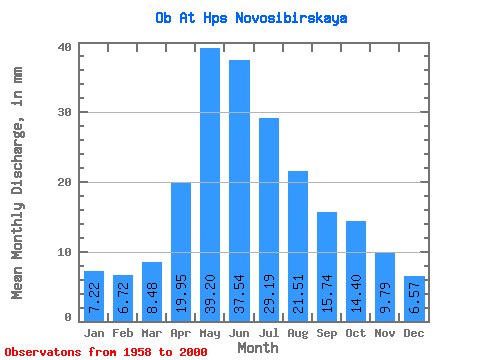
| Statistic | Jan | Feb | Mar | Apr | May | Jun | Jul | Aug | Sep | Oct | Nov | Dec | Annual |
|---|---|---|---|---|---|---|---|---|---|---|---|---|---|
| Mean | 7.22 | 6.78 | 8.48 | 19.95 | 39.20 | 37.54 | 29.19 | 21.51 | 15.74 | 14.40 | 9.79 | 6.57 | 215.84 |
| Standard Deviation | 1.63 | 1.50 | 1.60 | 6.96 | 13.62 | 12.05 | 10.93 | 7.54 | 3.33 | 3.41 | 1.97 | 1.17 | 41.20 |
| Min | 5.06 | 4.69 | 4.94 | 9.26 | 21.59 | 20.56 | 15.35 | 13.51 | 10.21 | 9.14 | 6.26 | 5.03 | 157.37 |
| Max | 12.93 | 10.34 | 12.81 | 34.41 | 79.88 | 78.21 | 57.72 | 45.59 | 23.69 | 23.09 | 13.85 | 10.56 | 316.88 |
| Coefficient of Variation | 0.23 | 0.22 | 0.19 | 0.35 | 0.35 | 0.32 | 0.37 | 0.35 | 0.21 | 0.24 | 0.20 | 0.18 | 0.19 |
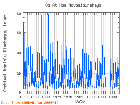
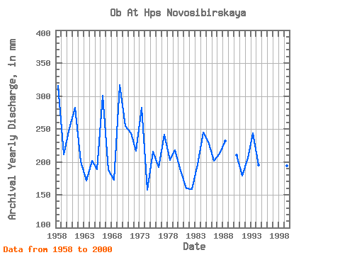
| Year | Jan | Feb | Mar | Apr | May | Jun | Jul | Aug | Sep | Oct | Nov | Dec | Annual | 1958 | 7.26 | 4.87 | 4.94 | 12.40 | 73.07 | 62.68 | 57.72 | 43.29 | 19.33 | 16.05 | 9.99 | 5.64 | 315.41 | 1959 | 5.21 | 4.78 | 7.65 | 15.75 | 50.67 | 41.56 | 31.17 | 19.28 | 14.08 | 9.52 | 6.26 | 6.04 | 211.15 | 1960 | 9.38 | 7.42 | 8.35 | 11.28 | 47.21 | 41.56 | 44.21 | 30.13 | 23.02 | 15.01 | 7.42 | 6.96 | 250.86 | 1961 | 9.14 | 10.34 | 10.97 | 33.74 | 47.79 | 42.68 | 36.36 | 29.20 | 23.69 | 18.58 | 12.07 | 8.03 | 282.17 | 1962 | 12.93 | 10.33 | 10.78 | 24.02 | 40.17 | 36.42 | 16.62 | 14.43 | 10.67 | 9.51 | 7.88 | 7.14 | 200.87 | 1963 | 8.96 | 6.50 | 8.98 | 14.41 | 28.97 | 24.58 | 20.66 | 15.58 | 12.07 | 11.66 | 11.84 | 7.61 | 171.41 | 1964 | 9.00 | 8.76 | 6.67 | 10.11 | 45.48 | 37.20 | 28.05 | 17.32 | 13.85 | 10.97 | 8.69 | 5.89 | 201.49 | 1965 | 7.20 | 6.34 | 7.91 | 20.67 | 40.98 | 26.25 | 18.70 | 13.62 | 15.53 | 15.24 | 8.78 | 7.98 | 188.74 | 1966 | 9.85 | 7.72 | 7.73 | 18.66 | 79.88 | 62.68 | 53.33 | 22.62 | 14.19 | 12.58 | 6.75 | 5.84 | 300.49 | 1967 | 6.07 | 5.45 | 7.51 | 17.76 | 21.59 | 21.34 | 22.39 | 34.28 | 21.34 | 15.47 | 9.38 | 5.84 | 187.85 | 1968 | 6.00 | 5.29 | 7.87 | 23.57 | 37.40 | 31.95 | 16.51 | 13.85 | 10.39 | 9.14 | 6.37 | 5.03 | 173.14 | 1969 | 5.33 | 6.15 | 8.29 | 13.41 | 77.92 | 78.21 | 42.48 | 22.74 | 19.66 | 22.28 | 13.52 | 7.94 | 316.88 | 1970 | 7.88 | 6.98 | 10.09 | 34.41 | 35.78 | 49.16 | 33.36 | 22.74 | 16.87 | 18.58 | 13.07 | 6.22 | 254.95 | 1971 | 6.26 | 6.86 | 11.19 | 28.15 | 52.17 | 43.80 | 36.59 | 18.58 | 14.19 | 11.54 | 9.63 | 5.51 | 243.86 | 1972 | 5.06 | 4.69 | 6.83 | 27.37 | 39.59 | 39.33 | 29.20 | 19.85 | 14.97 | 15.01 | 9.84 | 5.59 | 216.87 | 1973 | 9.51 | 8.95 | 8.84 | 31.17 | 53.33 | 51.28 | 48.60 | 23.78 | 15.75 | 15.24 | 11.28 | 5.85 | 282.93 | 1974 | 5.83 | 6.27 | 6.64 | 20.33 | 29.55 | 22.34 | 16.51 | 13.51 | 10.21 | 11.66 | 8.74 | 6.00 | 157.37 | 1975 | 6.49 | 5.59 | 7.26 | 27.71 | 29.55 | 47.59 | 35.21 | 16.28 | 13.97 | 13.62 | 7.63 | 5.26 | 215.98 | 1976 | 5.62 | 4.99 | 6.03 | 11.40 | 35.78 | 33.63 | 23.09 | 25.86 | 14.97 | 16.51 | 8.68 | 6.41 | 192.21 | 1977 | 8.69 | 8.10 | 8.65 | 27.93 | 48.48 | 39.22 | 22.86 | 22.28 | 17.65 | 16.05 | 13.74 | 7.75 | 241.04 | 1978 | 6.98 | 7.21 | 8.21 | 29.94 | 35.32 | 28.15 | 21.93 | 21.36 | 15.08 | 12.58 | 10.61 | 5.28 | 202.45 | 1979 | 5.24 | 5.38 | 6.26 | 12.40 | 45.94 | 44.80 | 26.32 | 16.51 | 16.54 | 15.12 | 13.85 | 10.56 | 218.37 | 1980 | 7.77 | 5.93 | 7.87 | 13.74 | 25.74 | 34.75 | 27.59 | 17.78 | 14.97 | 13.51 | 11.28 | 6.11 | 186.69 | 1981 | 6.56 | 6.11 | 7.69 | 16.09 | 24.93 | 24.47 | 15.35 | 15.12 | 13.41 | 13.39 | 10.77 | 6.41 | 160.11 | 1982 | 7.08 | 6.11 | 6.00 | 12.85 | 26.43 | 28.04 | 15.70 | 16.16 | 12.62 | 11.12 | 11.09 | 5.82 | 158.87 | 1983 | 6.26 | 5.97 | 9.21 | 15.75 | 26.09 | 33.63 | 28.28 | 21.59 | 13.97 | 16.85 | 11.73 | 7.54 | 196.35 | 1984 | 6.89 | 6.28 | 7.91 | 12.74 | 32.44 | 41.67 | 42.36 | 45.59 | 16.87 | 14.43 | 10.10 | 8.98 | 245.10 | 1985 | 6.08 | 7.08 | 8.98 | 23.02 | 32.90 | 40.00 | 38.32 | 23.32 | 17.54 | 14.20 | 10.64 | 6.19 | 227.81 | 1986 | 8.53 | 9.11 | 8.43 | 20.22 | 40.63 | 30.17 | 23.20 | 17.66 | 15.75 | 13.74 | 8.90 | 5.70 | 201.74 | 1987 | 5.19 | 5.10 | 9.23 | 14.19 | 36.71 | 41.00 | 32.20 | 16.39 | 13.63 | 23.09 | 10.04 | 6.68 | 212.70 | 1988 | 7.45 | 8.89 | 9.43 | 24.13 | 40.63 | 33.07 | 27.82 | 32.32 | 16.76 | 14.31 | 10.71 | 7.37 | 232.32 | 1990 | 6.38 | 5.76 | 9.49 | 18.32 | 30.59 | 30.72 | 24.59 | 31.74 | 22.90 | 15.24 | 8.94 | 6.03 | 210.12 | 1991 | 8.09 | 7.55 | 9.41 | 18.99 | 35.90 | 20.56 | 19.39 | 18.58 | 14.41 | 12.12 | 9.56 | 5.54 | 179.68 | 1992 | 6.28 | 6.96 | 8.91 | 17.88 | 27.70 | 37.87 | 23.32 | 18.01 | 20.56 | 20.09 | 10.38 | 7.78 | 205.54 | 1993 | 7.73 | 6.62 | 10.49 | 21.56 | 36.94 | 47.93 | 48.60 | 21.47 | 15.75 | 13.39 | 7.34 | 6.59 | 243.68 | 1994 | 6.59 | 6.07 | 9.63 | 22.23 | 27.82 | 35.98 | 22.05 | 15.93 | 17.54 | 14.66 | 9.92 | 7.43 | 195.71 | 1997 | 7.13 | 9.33 | 12.81 | 32.51 | 36.36 | 21.34 | 17.89 | 16.16 | 15.64 | 11.17 | 7.72 | 5.47 | 193.49 | 1998 | 6.12 | 5.57 | 8.28 | 9.26 | 25.05 | 29.94 | 26.20 | 15.81 | 11.28 | 9.93 | 7.67 | 5.82 | 160.49 | 1999 | 6.01 | 6.05 | 7.27 | 16.98 | 31.63 | 28.82 | 21.01 | 22.28 | 15.42 | 21.59 | 10.57 | 7.69 | 194.73 | 2000 | 8.66 | 7.74 | 10.39 | 21.00 | 32.67 | 35.30 | 31.74 | 17.32 | 12.62 | 11.39 | 8.24 | 5.40 | 202.11 |
|---|
| Other Close Sites | ||||||
|---|---|---|---|---|---|---|
| PointID | Latitude | Longitude | Drainage Area | Source | Name | |
| 6661 | "Ob At Novosibirsk" | 55.00 | -470289 | SHI | 2963.00 | |
| 6752 | "Inya (Nyzhnyaya) At Berezovka" | 55.00 | -445058 | SHI | 35.00 | |
 Return to R-Arctic Net Home Page