|
|
|||||||||||||||||
| Point ID: 6568 | Downloads | Plots | Site Data | Code: 9205 |
|
|
|||||||||||||||||
| Download | |
|---|---|
| Site Descriptor Information | Site Time Series Data |
| Link to all available data | |
|
|
| View: | Statistics | Time Series |
| Units: | m3/s |
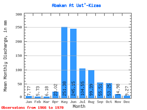
| Statistic | Jan | Feb | Mar | Apr | May | Jun | Jul | Aug | Sep | Oct | Nov | Dec | Annual |
|---|---|---|---|---|---|---|---|---|---|---|---|---|---|
| Mean | 7.77 | 5.78 | 6.18 | 23.02 | 251.34 | 245.15 | 104.54 | 99.38 | 55.51 | 53.24 | 14.98 | 9.27 | 853.86 |
| Standard Deviation | 1.11 | 1.78 | 2.55 | 8.83 | 82.12 | 120.65 | 42.74 | 66.06 | 19.82 | 27.54 | 5.11 | 2.14 | 198.56 |
| Min | 6.49 | 4.70 | 3.18 | 11.74 | 171.65 | 98.37 | 50.98 | 64.85 | 32.48 | 34.52 | 10.65 | 6.81 | 642.23 |
| Max | 9.00 | 8.44 | 9.36 | 32.17 | 374.27 | 424.71 | 152.94 | 198.43 | 80.57 | 84.86 | 20.61 | 10.68 | 1036.05 |
| Coefficient of Variation | 0.14 | 0.31 | 0.41 | 0.38 | 0.33 | 0.49 | 0.41 | 0.67 | 0.36 | 0.52 | 0.34 | 0.23 | 0.23 |
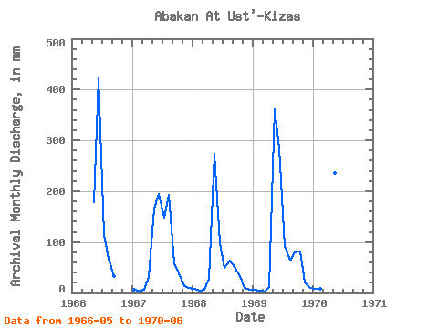
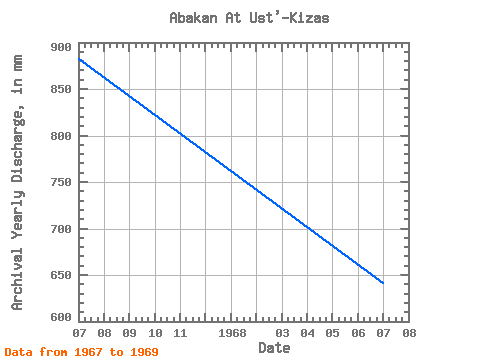
| Year | Jan | Feb | Mar | Apr | May | Jun | Jul | Aug | Sep | Oct | Nov | Dec | Annual | 1966 | 184.23 | 424.71 | 118.41 | 69.05 | 32.48 | 1967 | 7.29 | 4.94 | 5.61 | 32.17 | 171.65 | 194.24 | 152.94 | 198.43 | 57.46 | 40.33 | 13.68 | 10.32 | 883.30 | 1968 | 8.29 | 5.03 | 6.55 | 27.32 | 282.32 | 98.37 | 50.98 | 64.85 | 51.53 | 34.52 | 10.65 | 6.81 | 642.23 | 1969 | 6.49 | 4.70 | 3.18 | 11.74 | 374.27 | 283.25 | 95.83 | 65.17 | 80.57 | 84.86 | 20.61 | 10.68 | 1036.05 | 1970 | 9.00 | 8.44 | 9.36 | 20.86 | 244.25 | 225.16 |
|---|
 Return to R-Arctic Net Home Page