|
|
|||||||||||||||||
| Point ID: 6555 | Downloads | Plots | Site Data | Other Close Sites | Code: 9127 |
|
|
|||||||||||||||||
| Download | |
|---|---|
| Site Descriptor Information | Site Time Series Data |
| Link to all available data | |
|
|
| View: | Statistics | Time Series |
| Units: | m3/s |
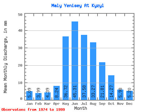
| Statistic | Jan | Feb | Mar | Apr | May | Jun | Jul | Aug | Sep | Oct | Nov | Dec | Annual |
|---|---|---|---|---|---|---|---|---|---|---|---|---|---|
| Mean | 5.09 | 4.03 | 4.39 | 8.24 | 36.71 | 45.31 | 37.57 | 33.26 | 21.81 | 14.27 | 5.97 | 5.20 | 220.92 |
| Standard Deviation | 1.00 | 0.67 | 0.80 | 2.75 | 10.24 | 14.40 | 11.99 | 10.12 | 5.32 | 2.98 | 1.38 | 1.04 | 34.90 |
| Min | 3.67 | 3.22 | 3.49 | 4.22 | 20.70 | 21.05 | 20.75 | 17.37 | 13.89 | 8.36 | 3.97 | 3.74 | 165.03 |
| Max | 6.81 | 5.37 | 6.12 | 16.06 | 57.12 | 74.31 | 61.24 | 60.32 | 35.74 | 21.07 | 10.79 | 7.50 | 264.33 |
| Coefficient of Variation | 0.20 | 0.17 | 0.18 | 0.33 | 0.28 | 0.32 | 0.32 | 0.30 | 0.24 | 0.21 | 0.23 | 0.20 | 0.16 |
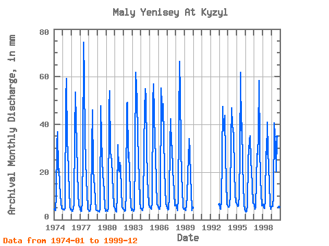
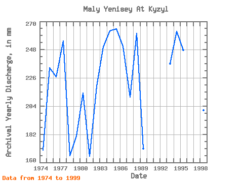
| Year | Jan | Feb | Mar | Apr | May | Jun | Jul | Aug | Sep | Oct | Nov | Dec | Annual | 1974 | 4.71 | 3.79 | 3.96 | 10.35 | 32.40 | 36.76 | 21.39 | 21.94 | 15.48 | 10.42 | 4.64 | 4.54 | 169.88 | 1975 | 4.66 | 3.83 | 4.27 | 5.09 | 52.55 | 59.27 | 33.04 | 29.98 | 20.17 | 12.38 | 5.49 | 4.44 | 234.25 | 1976 | 4.32 | 3.26 | 3.69 | 6.37 | 37.79 | 53.52 | 42.36 | 32.99 | 20.21 | 11.65 | 5.84 | 5.85 | 226.90 | 1977 | 4.52 | 3.32 | 3.83 | 7.65 | 29.07 | 74.31 | 61.24 | 34.82 | 16.45 | 11.84 | 4.47 | 4.25 | 254.86 | 1978 | 3.67 | 3.26 | 4.35 | 8.05 | 31.26 | 46.00 | 21.34 | 17.37 | 13.89 | 8.36 | 4.17 | 3.90 | 165.30 | 1979 | 4.01 | 3.46 | 3.49 | 4.69 | 49.36 | 34.01 | 26.92 | 18.46 | 16.72 | 11.61 | 5.35 | 3.74 | 180.86 | 1980 | 3.88 | 3.54 | 3.74 | 4.78 | 48.44 | 53.96 | 29.29 | 25.91 | 18.09 | 12.48 | 5.62 | 5.35 | 214.25 | 1981 | 4.51 | 3.43 | 3.52 | 10.17 | 32.35 | 21.05 | 20.75 | 24.59 | 22.03 | 12.84 | 5.71 | 4.80 | 165.03 | 1982 | 4.31 | 3.33 | 3.87 | 11.37 | 50.27 | 49.10 | 26.73 | 29.11 | 20.04 | 12.29 | 5.66 | 4.13 | 219.39 | 1983 | 4.54 | 3.85 | 3.83 | 4.22 | 28.70 | 61.92 | 51.64 | 36.88 | 25.30 | 17.64 | 7.79 | 4.89 | 250.30 | 1984 | 4.98 | 3.88 | 3.88 | 5.57 | 31.72 | 45.12 | 56.67 | 53.01 | 29.95 | 17.91 | 6.33 | 5.44 | 262.92 | 1985 | 5.35 | 4.54 | 4.51 | 7.43 | 51.18 | 57.06 | 45.70 | 34.05 | 26.80 | 16.18 | 6.63 | 6.03 | 264.33 | 1986 | 5.39 | 4.29 | 4.62 | 6.55 | 57.12 | 41.49 | 50.27 | 34.96 | 21.50 | 13.34 | 6.68 | 6.03 | 250.61 | 1987 | 4.98 | 3.87 | 4.56 | 9.78 | 32.35 | 42.42 | 32.17 | 32.22 | 20.21 | 17.73 | 5.93 | 6.03 | 211.37 | 1988 | 6.49 | 4.83 | 4.14 | 9.16 | 42.73 | 66.35 | 55.30 | 31.26 | 18.45 | 13.30 | 5.35 | 4.49 | 260.84 | 1989 | 4.94 | 3.88 | 4.14 | 9.24 | 20.70 | 25.17 | 35.23 | 29.43 | 17.56 | 12.43 | 3.97 | 5.21 | 171.02 | 1993 | 6.81 | 4.46 | 4.51 | 7.79 | 27.33 | 47.33 | 38.62 | 45.24 | 26.76 | 16.59 | 6.46 | 6.12 | 237.05 | 1994 | 5.44 | 5.12 | 6.12 | 10.44 | 34.37 | 46.89 | 40.99 | 39.07 | 35.74 | 21.07 | 10.79 | 7.50 | 262.69 | 1995 | 6.67 | 5.37 | 5.94 | 10.48 | 28.70 | 61.92 | 38.66 | 42.00 | 22.25 | 15.90 | 6.37 | 4.20 | 247.82 | 1996 | 3.79 | 3.22 | 3.57 | 6.02 | 25.82 | 33.48 | 36.15 | 25.36 | 20.70 | 14.39 | 6.94 | 7.08 | 185.70 | 1997 | 6.72 | 4.29 | 5.53 | 16.06 | 28.61 | 27.25 | 36.51 | 60.32 | 31.05 | 17.50 | 5.79 | 6.58 | 244.82 | 1998 | 6.58 | 4.66 | 4.98 | 8.36 | 29.61 | 27.38 | 42.18 | 29.93 | 22.03 | 15.95 | 6.10 | 4.52 | 201.19 | 1999 | 5.85 | 5.16 | 5.89 | 9.82 | 41.95 | 30.43 | 20.98 | 36.10 | 20.17 | 14.44 | 5.35 | 4.47 | 199.66 |
|---|
| Other Close Sites | ||||||
|---|---|---|---|---|---|---|
| PointID | Latitude | Longitude | Drainage Area | Source | Name | |
| 6537 | "Yenisey at Kyizyil" | 51.72 | 320529 | SHI | 3486.00 | |
| 6548 | "Bol'shoy Yenisey At Kara-Khak" | 51.88 | 324040 | SHI | 20.00 | |
 Return to R-Arctic Net Home Page