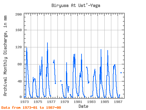
| Point ID: 6510 | Downloads | Plots | Site Data | Code: 8327 |
| Download | |
|---|---|
| Site Descriptor Information | Site Time Series Data |
| Link to all available data | |

|

|
| View: | Statistics | Time Series |
| Units: | m3/s |
| Statistic | Jan | Feb | Mar | Apr | May | Jun | Jul | Aug | Sep | Oct | Nov | Dec | Annual |
|---|---|---|---|---|---|---|---|---|---|---|---|---|---|
| Mean | 4.55 | 2.76 | 2.79 | 7.58 | 75.65 | 61.56 | 73.84 | 67.24 | 46.56 | 23.90 | 9.93 | 7.16 | 399.01 |
| Standard Deviation | 1.58 | 1.37 | 1.53 | 9.36 | 17.91 | 25.16 | 30.91 | 27.36 | 18.75 | 4.93 | 2.56 | 2.63 | 62.69 |
| Min | 1.94 | 1.23 | 1.35 | 2.17 | 50.47 | 34.24 | 26.78 | 13.41 | 26.23 | 17.87 | 7.04 | 2.91 | 273.11 |
| Max | 7.78 | 6.05 | 5.82 | 36.48 | 109.12 | 117.94 | 134.58 | 107.30 | 96.81 | 31.19 | 14.35 | 12.46 | 491.56 |
| Coefficient of Variation | 0.35 | 0.50 | 0.55 | 1.23 | 0.24 | 0.41 | 0.42 | 0.41 | 0.40 | 0.21 | 0.26 | 0.37 | 0.16 |
| Year | Jan | Feb | Mar | Apr | May | Jun | Jul | Aug | Sep | Oct | Nov | Dec | Annual | 1973 | 4.51 | 2.18 | 2.88 | 6.12 | 109.12 | 117.94 | 84.11 | 62.29 | 39.52 | 20.32 | 7.79 | 8.41 | 462.65 | 1974 | 4.77 | 2.05 | 1.79 | 2.17 | 50.47 | 38.59 | 44.69 | 47.74 | 44.45 | 26.51 | 7.39 | 4.20 | 273.11 | 1975 | 4.05 | 2.51 | 2.66 | 4.33 | 78.66 | 59.85 | 54.56 | 67.75 | 96.81 | 28.42 | 9.95 | 9.55 | 417.38 | 1976 | 5.41 | 3.02 | 4.42 | 5.81 | 75.02 | 51.05 | 134.58 | 68.20 | 33.49 | 19.69 | 7.04 | 5.27 | 409.06 | 1977 | 83.61 | 93.21 | 63.20 | 35.03 | 1978 | 41.83 | 32.08 | 18.00 | 8.10 | 4.91 | 1979 | 1.94 | 1.23 | 1.35 | 2.60 | 85.93 | 35.78 | 26.78 | 13.41 | 27.11 | 8.28 | 1980 | 6.50 | 3.41 | 1.66 | 2.51 | 84.11 | 102.98 | 75.47 | 107.30 | 57.65 | 27.60 | 12.72 | 12.46 | 491.56 | 1981 | 7.78 | 6.05 | 5.82 | 36.48 | 60.93 | 50.61 | 50.47 | 106.85 | 50.17 | 17.87 | 8.19 | 7.87 | 407.05 | 1982 | 5.59 | 3.14 | 75.02 | 72.17 | 65.93 | 36.01 | 37.76 | 1983 | 4.87 | 4.85 | 5.27 | 5.59 | 52.74 | 50.61 | 59.56 | 70.47 | 47.97 | 29.96 | 14.35 | 7.64 | 351.86 | 1984 | 4.11 | 2.23 | 2.01 | 4.84 | 75.47 | 34.24 | 118.21 | 43.92 | 26.23 | 21.32 | 11.62 | 2.91 | 343.62 | 1985 | 2.34 | 2.02 | 2.32 | 9.37 | 55.02 | 53.69 | 115.94 | 66.38 | 60.29 | 22.01 | 9.20 | 5.87 | 401.70 | 1986 | 3.70 | 1.86 | 1.64 | 3.42 | 78.20 | 67.77 | 80.48 | 81.84 | 63.37 | 31.19 | 12.94 | 8.55 | 432.14 | 1987 | 3.66 | 1.37 | 1.68 | 7.75 | 102.75 | 42.95 | 61.84 | 105.94 |
|---|
 Return to R-Arctic Net Home Page