|
|
|||||||||||||||||
| Point ID: 631 | Downloads | Plots | Site Data | Code: 07AG002 |
|
|
|||||||||||||||||
| Download | |
|---|---|
| Site Descriptor Information | Site Time Series Data |
| Link to all available data | |
|
|
| View: | Statistics | Time Series |
| Units: | m3/s |
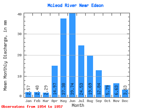
| Statistic | Jan | Feb | Mar | Apr | May | Jun | Jul | Aug | Sep | Oct | Nov | Dec | Annual |
|---|---|---|---|---|---|---|---|---|---|---|---|---|---|
| Mean | 2.54 | 2.47 | 2.27 | 14.81 | 36.97 | 39.30 | 24.26 | 19.48 | 12.70 | 5.73 | 6.56 | 3.59 | 156.85 |
| Standard Deviation | 0.26 | 0.47 | 0.21 | 2.81 | 10.78 | 16.52 | 9.80 | 11.29 | 8.30 | 1.28 | 3.98 | 0.52 | 42.44 |
| Min | 2.25 | 1.94 | 2.09 | 11.89 | 24.81 | 26.78 | 13.96 | 12.14 | 5.85 | 4.83 | 3.17 | 3.10 | 126.84 |
| Max | 2.72 | 2.81 | 2.51 | 17.50 | 45.35 | 58.02 | 33.46 | 32.48 | 21.93 | 6.63 | 10.94 | 4.14 | 186.87 |
| Coefficient of Variation | 0.10 | 0.19 | 0.10 | 0.19 | 0.29 | 0.42 | 0.40 | 0.58 | 0.65 | 0.22 | 0.61 | 0.14 | 0.27 |
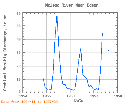
| Year | Jan | Feb | Mar | Apr | May | Jun | Jul | Aug | Sep | Oct | Nov | Dec | Annual | 1954 | 10.94 | 4.14 | 1955 | 2.72 | 2.67 | 2.09 | 15.03 | 40.73 | 58.02 | 33.46 | 13.81 | 5.85 | 6.63 | 3.17 | 3.10 | 186.87 | 1956 | 2.67 | 1.94 | 2.21 | 11.89 | 24.81 | 33.10 | 13.96 | 12.14 | 10.32 | 4.83 | 5.56 | 3.52 | 126.84 | 1957 | 2.25 | 2.81 | 2.51 | 17.50 | 45.35 | 26.78 | 25.36 | 32.48 | 21.93 |
|---|
 Return to R-Arctic Net Home Page