|
|
|||||||||||||||||
| Point ID: 6042 | Downloads | Plots | Site Data | Code: 7016 |
|
|
|||||||||||||||||
| Download | |
|---|---|
| Site Descriptor Information | Site Time Series Data |
| Link to all available data | |
|
|
| View: | Statistics | Time Series |
| Units: | m3/s |
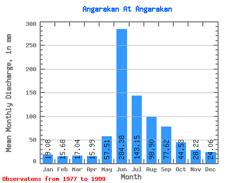
| Statistic | Jan | Feb | Mar | Apr | May | Jun | Jul | Aug | Sep | Oct | Nov | Dec | Annual |
|---|---|---|---|---|---|---|---|---|---|---|---|---|---|
| Mean | 19.08 | 15.81 | 17.04 | 15.99 | 57.51 | 284.38 | 143.12 | 98.89 | 77.62 | 44.53 | 28.22 | 24.06 | 826.18 |
| Standard Deviation | 3.08 | 1.89 | 2.18 | 1.76 | 28.59 | 76.85 | 60.38 | 35.88 | 20.50 | 8.38 | 4.00 | 3.02 | 127.98 |
| Min | 11.48 | 12.49 | 14.06 | 13.69 | 22.22 | 168.50 | 68.78 | 46.85 | 45.35 | 33.53 | 21.55 | 18.91 | 613.43 |
| Max | 25.53 | 19.35 | 21.41 | 19.60 | 127.67 | 528.38 | 263.07 | 193.00 | 129.81 | 64.05 | 36.20 | 29.45 | 1093.50 |
| Coefficient of Variation | 0.16 | 0.12 | 0.13 | 0.11 | 0.50 | 0.27 | 0.42 | 0.36 | 0.26 | 0.19 | 0.14 | 0.13 | 0.15 |
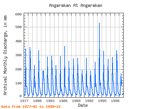
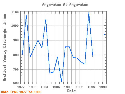
| Year | Jan | Feb | Mar | Apr | May | Jun | Jul | Aug | Sep | Oct | Nov | Dec | Annual | 1977 | 17.19 | 13.63 | 14.36 | 13.90 | 49.00 | 341.99 | 88.55 | 80.81 | 81.55 | 41.95 | 29.16 | 28.03 | 802.30 | 1978 | 17.15 | 12.49 | 14.19 | 15.35 | 28.76 | 355.72 | 263.07 | 150.88 | 94.03 | 61.04 | 34.82 | 26.74 | 1072.47 | 1979 | 21.45 | 17.62 | 19.39 | 16.27 | 107.46 | 229.66 | 74.80 | 118.64 | 91.95 | 41.78 | 26.63 | 20.38 | 785.50 | 1980 | 11.48 | 14.06 | 16.72 | 15.23 | 22.22 | 333.26 | 193.44 | 86.83 | 56.58 | 41.14 | 27.58 | 26.35 | 845.19 | 1981 | 21.19 | 15.51 | 17.62 | 17.43 | 79.52 | 188.06 | 193.44 | 125.52 | 129.81 | 64.05 | 25.30 | 24.03 | 898.55 | 1982 | 19.09 | 16.53 | 16.46 | 16.81 | 30.39 | 286.66 | 151.74 | 126.81 | 74.89 | 46.85 | 36.20 | 26.65 | 848.95 | 1983 | 18.27 | 14.65 | 14.53 | 14.56 | 39.89 | 293.32 | 238.14 | 193.00 | 108.59 | 58.89 | 30.08 | 24.33 | 1045.41 | 1984 | 19.95 | 16.72 | 15.73 | 16.48 | 83.82 | 226.33 | 101.88 | 62.76 | 51.17 | 36.06 | 22.38 | 21.71 | 674.81 | 1985 | 20.42 | 17.35 | 19.43 | 17.39 | 40.36 | 290.40 | 91.56 | 48.57 | 59.08 | 35.08 | 21.55 | 18.91 | 682.24 | 1986 | 15.99 | 15.55 | 15.60 | 14.19 | 52.44 | 363.21 | 77.80 | 76.94 | 56.58 | 41.61 | 27.21 | 25.96 | 785.58 | 1987 | 19.69 | 16.45 | 15.22 | 18.43 | 34.39 | 256.70 | 68.78 | 46.85 | 55.34 | 33.53 | 24.92 | 20.93 | 613.43 | 1988 | 18.18 | 13.51 | 14.06 | 15.77 | 55.02 | 273.35 | 176.24 | 107.89 | 86.54 | 42.69 | 26.50 | 26.44 | 855.24 | 1989 | 25.53 | 17.90 | 18.14 | 17.60 | 68.78 | 278.75 | 192.15 | 84.68 | 64.49 | 41.40 | 26.09 | 22.39 | 856.84 | 1990 | 17.75 | 14.22 | 16.89 | 14.56 | 93.71 | 191.80 | 123.37 | 116.92 | 80.30 | 52.44 | 33.66 | 29.45 | 782.79 | 1991 | 23.86 | 18.68 | 21.28 | 19.60 | 55.45 | 278.75 | 100.16 | 74.80 | 79.47 | 47.28 | 32.12 | 26.01 | 778.66 | 1992 | 23.81 | 19.35 | 16.42 | 14.06 | 127.67 | 188.89 | 129.82 | 74.80 | 73.64 | 40.32 | 24.55 | 20.29 | 751.77 | 1993 | 17.62 | 16.06 | 16.94 | 13.69 | 45.56 | 250.05 | 79.09 | 98.44 | 90.70 | 51.15 | 33.53 | 21.97 | 735.81 | 1994 | 18.87 | 17.59 | 21.41 | 14.23 | 34.26 | 528.38 | 160.34 | 88.98 | 101.10 | 45.99 | 31.25 | 26.95 | 1093.50 | 1995 | 22.57 | 17.31 | 17.97 | 16.10 | 22.27 | 327.43 | 140.99 | 61.90 | 69.48 | 42.90 | 27.67 | 23.51 | 791.96 | 1996 | 18.05 | 15.20 | 16.46 | 14.73 | 64.05 | 272.10 | 108.32 | 65.34 | 64.07 | 37.14 | 24.71 | 20.93 | 721.88 | 1997 | 17.50 | 12.88 | 15.30 | 18.02 | 61.90 | 284.58 | 212.78 | 133.25 | 96.11 | 48.14 | 31.37 | 27.12 | 957.02 | 1998 | 17.24 | 16.49 | 17.32 | 14.56 | 32.45 | 332.84 | 242.44 | 140.56 | 45.35 | 33.92 | 26.46 | 19.69 | 937.72 | 1999 | 15.95 | 13.98 | 20.50 | 18.93 | 93.28 | 168.50 | 82.96 | 109.18 | 74.47 | 38.73 | 25.21 | 24.55 | 684.64 |
|---|
 Return to R-Arctic Net Home Page