|
|
|||||||||||||||||
| Point ID: 601 | Downloads | Plots | Site Data | Code: 07AD003 |
|
|
|||||||||||||||||
| Download | |
|---|---|
| Site Descriptor Information | Site Time Series Data |
| Link to all available data | |
|
|
| View: | Statistics | Time Series |
| Units: | m3/s |
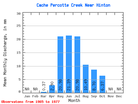
| Statistic | Jan | Feb | Mar | Apr | May | Jun | Jul | Aug | Sep | Oct | Nov | Dec | Annual |
|---|---|---|---|---|---|---|---|---|---|---|---|---|---|
| Mean | 0.19 | 2.90 | 20.90 | 21.43 | 21.11 | 10.32 | 8.76 | 6.30 | |||||
| Standard Deviation | 0.27 | 3.08 | 15.26 | 15.37 | 25.55 | 10.98 | 12.07 | 7.70 | |||||
| Min | 0.00 | 0.72 | 8.99 | 3.26 | 2.62 | 0.38 | 0.36 | 0.38 | |||||
| Max | 0.38 | 5.08 | 51.31 | 46.77 | 72.29 | 31.46 | 39.51 | 23.60 | |||||
| Coefficient of Variation | 1.41 | 1.06 | 0.73 | 0.72 | 1.21 | 1.06 | 1.38 | 1.22 |
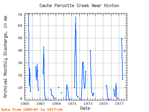
| Year | Jan | Feb | Mar | Apr | May | Jun | Jul | Aug | Sep | Oct | Nov | Dec | Annual | 1965 | 72.29 | 11.61 | 25.38 | 7.12 | 1966 | 26.83 | 16.48 | 29.96 | 11.96 | 8.24 | 1967 | 22.10 | 43.14 | 7.49 | 2.25 | 0.72 | 0.75 | 1968 | 8.99 | 3.99 | 3.75 | 3.75 | 1.81 | 1.50 | 1969 | 10.49 | 5.80 | 1970 | 0.00 | 0.72 | 12.73 | 9.79 | 8.24 | 1.50 | 0.36 | 0.38 | 1971 | 10.11 | 46.77 | 69.29 | 3.75 | 3.26 | 2.62 | 1972 | 0.38 | 5.08 | 31.09 | 30.81 | 14.61 | 9.36 | 10.51 | 23.60 | 1973 | 41.20 | 21.75 | 7.12 | 5.24 | 3.26 | 5.62 | 1975 | 11.98 | 11.24 | 3.75 | 0.38 | 0.36 | 0.38 | 1976 | 8.99 | 3.26 | 2.62 | 14.23 | 2.17 | 1.50 | 1977 | 51.31 | 16.68 | 26.59 | 31.46 | 39.51 | 17.60 |
|---|
 Return to R-Arctic Net Home Page