|
|
|||||||||||||||||
| Point ID: 5614 | Downloads | Plots | Site Data | Other Close Sites | Code: 07LE001 |
|
|
|||||||||||||||||
| Download | |
|---|---|
| Site Descriptor Information | Site Time Series Data |
| Link to all available data | |
|
|
| View: | Statistics | Time Series |
| Units: | m3/s |
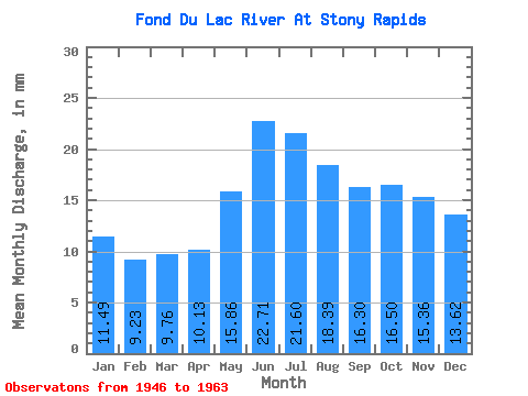
| Statistic | Jan | Feb | Mar | Apr | May | Jun | Jul | Aug | Sep | Oct | Nov | Dec | Annual |
|---|---|---|---|---|---|---|---|---|---|---|---|---|---|
| Mean | 11.49 | 9.31 | 9.76 | 10.13 | 15.86 | 22.71 | 21.60 | 18.39 | 16.30 | 16.50 | 15.36 | 13.62 | 182.01 |
| Standard Deviation | 2.97 | 2.43 | 1.77 | 1.34 | 3.15 | 6.24 | 6.46 | 4.48 | 4.06 | 4.80 | 4.67 | 3.51 | 38.54 |
| Min | 7.50 | 6.22 | 7.13 | 8.66 | 10.08 | 12.76 | 12.41 | 11.12 | 10.41 | 10.44 | 9.76 | 8.84 | 128.10 |
| Max | 18.97 | 15.83 | 14.32 | 12.96 | 20.58 | 34.08 | 39.29 | 28.59 | 23.82 | 23.52 | 25.72 | 20.68 | 247.62 |
| Coefficient of Variation | 0.26 | 0.26 | 0.18 | 0.13 | 0.20 | 0.28 | 0.30 | 0.24 | 0.25 | 0.29 | 0.30 | 0.26 | 0.21 |
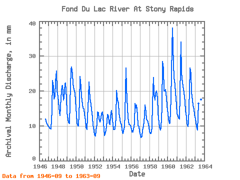
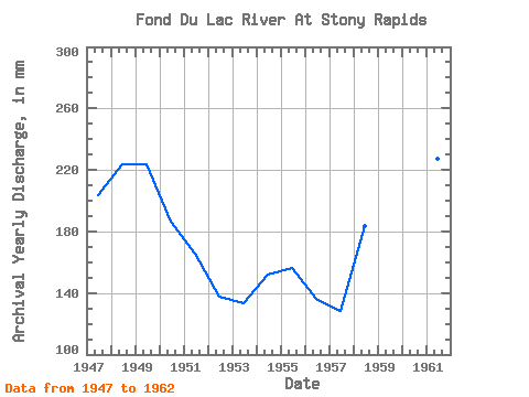
| Year | Jan | Feb | Mar | Apr | May | Jun | Jul | Aug | Sep | Oct | Nov | Dec | Annual | 1946 | 11.91 | 11.17 | 10.56 | 10.29 | 1947 | 9.98 | 8.81 | 9.51 | 9.16 | 14.89 | 23.07 | 21.82 | 18.35 | 18.51 | 23.52 | 25.72 | 20.68 | 203.70 | 1948 | 18.97 | 15.83 | 14.32 | 12.96 | 18.61 | 21.42 | 22.23 | 17.94 | 18.11 | 22.80 | 22.27 | 18.66 | 224.06 | 1949 | 14.32 | 11.07 | 11.32 | 10.66 | 17.06 | 26.02 | 27.76 | 25.69 | 22.02 | 21.09 | 19.36 | 17.68 | 223.65 | 1950 | 13.65 | 10.22 | 10.24 | 9.96 | 17.42 | 24.17 | 21.82 | 19.08 | 16.16 | 15.61 | 14.81 | 13.75 | 186.64 | 1951 | 11.94 | 9.00 | 9.25 | 12.56 | 18.77 | 22.57 | 18.46 | 16.65 | 14.71 | 12.87 | 10.31 | 9.00 | 165.92 | 1952 | 7.60 | 6.69 | 8.89 | 10.36 | 14.42 | 13.81 | 12.41 | 11.48 | 11.61 | 13.80 | 14.01 | 12.77 | 137.64 | 1953 | 9.31 | 6.83 | 8.38 | 8.66 | 11.68 | 13.31 | 13.29 | 11.12 | 10.41 | 13.18 | 14.41 | 13.29 | 133.63 | 1954 | 10.80 | 8.38 | 9.25 | 9.11 | 12.72 | 20.12 | 17.94 | 17.06 | 13.51 | 12.15 | 10.86 | 10.70 | 152.42 | 1955 | 9.10 | 7.35 | 8.74 | 9.66 | 14.06 | 26.57 | 21.45 | 15.61 | 12.36 | 10.80 | 10.46 | 10.44 | 156.43 | 1956 | 9.46 | 7.72 | 8.48 | 9.06 | 11.01 | 16.41 | 15.66 | 16.54 | 13.16 | 10.44 | 9.76 | 8.84 | 136.43 | 1957 | 7.50 | 6.22 | 7.13 | 8.71 | 10.08 | 12.76 | 16.54 | 14.42 | 11.86 | 11.99 | 11.16 | 9.98 | 128.10 | 1958 | 8.48 | 7.30 | 8.01 | 9.41 | 17.16 | 23.82 | 19.90 | 17.99 | 19.27 | 20.63 | 18.01 | 14.22 | 183.90 | 1959 | 11.17 | 9.14 | 9.05 | 9.36 | 15.82 | 28.47 | 27.30 | 20.68 | 19.96 | 21.09 | 17.96 | 16.29 | 205.93 | 1960 | 13.86 | 11.30 | 11.06 | 10.86 | 18.30 | 32.52 | 39.29 | 28.59 | 23.82 | 22.59 | 19.46 | 16.49 | 247.62 | 1961 | 13.91 | 12.20 | 12.67 | 11.91 | 19.96 | 34.08 | 26.11 | 23.01 | 21.47 | 20.21 | 17.01 | 14.73 | 227.10 | 1962 | 12.93 | 9.99 | 10.08 | 10.96 | 20.58 | 26.57 | 25.85 | 20.21 | 17.26 | 16.44 | 14.91 | 13.65 | 199.08 | 1963 | 12.41 | 10.22 | 9.56 | 8.86 | 17.01 | 20.32 | 19.39 | 18.15 | 17.31 |
|---|
| Other Close Sites | ||||||
|---|---|---|---|---|---|---|
| PointID | Latitude | Longitude | Drainage Area | Source | Name | |
| 5615 | "FOND DU LAC RIVER AT OUTLET OF BLACK LAKE" | 59.14 | 907720 | Hydat | ||
 Return to R-Arctic Net Home Page