|
|
|||||||||||||||||
| Point ID: 5580 | Downloads | Plots | Site Data | Code: 06BB002 |
|
|
|||||||||||||||||
| Download | |
|---|---|
| Site Descriptor Information | Site Time Series Data |
| Link to all available data | |
|
|
| View: | Statistics | Time Series |
| Units: | m3/s |
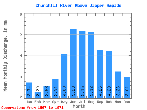
| Statistic | Jan | Feb | Mar | Apr | May | Jun | Jul | Aug | Sep | Oct | Nov | Dec | Annual |
|---|---|---|---|---|---|---|---|---|---|---|---|---|---|
| Mean | 2.56 | 2.16 | 2.41 | 2.72 | 3.82 | 4.88 | 4.80 | 4.77 | 3.97 | 3.95 | 3.04 | 2.81 | 34.81 |
| Standard Deviation | 0.12 | 0.14 | 0.24 | 0.30 | 0.76 | 2.35 | 2.81 | 2.35 | 1.88 | 1.38 | 0.18 | 0.05 | 5.58 |
| Min | 2.43 | 2.01 | 2.20 | 2.37 | 2.94 | 2.84 | 2.52 | 2.27 | 2.21 | 2.81 | 2.85 | 2.77 | 30.87 |
| Max | 2.65 | 2.28 | 2.67 | 2.91 | 4.29 | 7.44 | 7.94 | 7.66 | 6.59 | 5.96 | 3.20 | 2.86 | 38.76 |
| Coefficient of Variation | 0.04 | 0.07 | 0.10 | 0.11 | 0.20 | 0.48 | 0.58 | 0.49 | 0.47 | 0.35 | 0.06 | 0.02 | 0.16 |
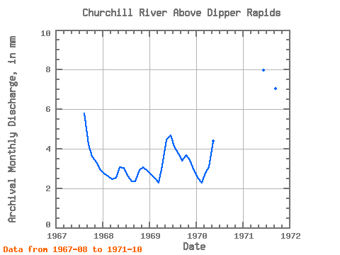
| Year | Jan | Feb | Mar | Apr | May | Jun | Jul | Aug | Sep | Oct | Nov | Dec | Annual | 1967 | 5.58 | 3.93 | 3.47 | 3.08 | 2.86 | 1968 | 2.65 | 2.28 | 2.37 | 2.37 | 2.94 | 2.84 | 2.52 | 2.27 | 2.21 | 2.81 | 2.85 | 2.77 | 30.87 | 1969 | 2.60 | 2.20 | 2.20 | 2.91 | 4.29 | 4.36 | 3.94 | 3.59 | 3.17 | 3.56 | 3.20 | 2.79 | 38.76 | 1970 | 2.43 | 2.01 | 2.67 | 2.87 | 4.22 | 1971 | 7.44 | 7.94 | 7.66 | 6.59 | 5.96 |
|---|
 Return to R-Arctic Net Home Page