|
|
|||||||||||||||||
| Point ID: 5556 | Downloads | Plots | Site Data | Code: 05ND010 |
|
|
|||||||||||||||||
| Download | |
|---|---|
| Site Descriptor Information | Site Time Series Data |
| Link to all available data | |
|
|
| View: | Statistics | Time Series |
| Units: | m3/s |
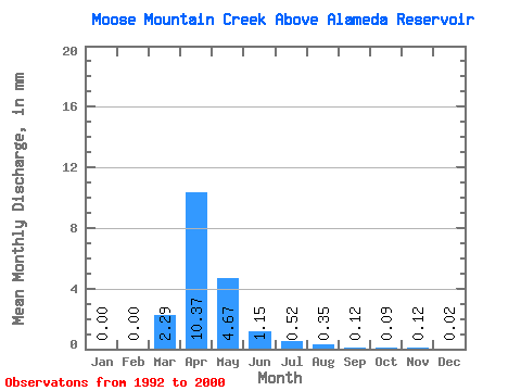
| Statistic | Jan | Feb | Mar | Apr | May | Jun | Jul | Aug | Sep | Oct | Nov | Dec | Annual |
|---|---|---|---|---|---|---|---|---|---|---|---|---|---|
| Mean | 0.00 | 0.00 | 0.94 | 4.27 | 1.92 | 0.47 | 0.21 | 0.14 | 0.05 | 0.04 | 0.05 | 0.01 | 8.13 |
| Standard Deviation | 0.00 | 0.01 | 1.48 | 5.33 | 2.27 | 0.45 | 0.13 | 0.19 | 0.05 | 0.03 | 0.06 | 0.01 | 7.63 |
| Min | 0.00 | 0.00 | 0.00 | 0.17 | 0.04 | 0.01 | 0.02 | 0.00 | 0.00 | 0.00 | 0.00 | 0.00 | 1.27 |
| Max | 0.01 | 0.02 | 4.34 | 13.87 | 5.86 | 1.29 | 0.39 | 0.52 | 0.15 | 0.09 | 0.18 | 0.03 | 21.19 |
| Coefficient of Variation | 2.29 | 3.00 | 1.58 | 1.25 | 1.18 | 0.96 | 0.63 | 1.34 | 1.11 | 0.87 | 1.17 | 1.13 | 0.94 |
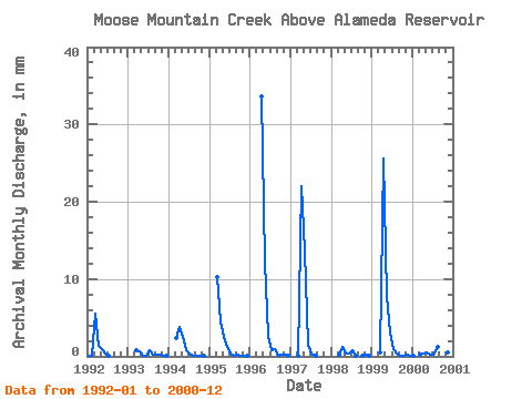
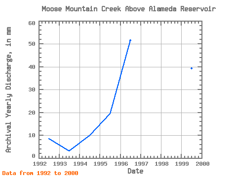
| Year | Jan | Feb | Mar | Apr | May | Jun | Jul | Aug | Sep | Oct | Nov | Dec | Annual | 1992 | 0.01 | 0.02 | 2.35 | 0.58 | 0.39 | 0.17 | 0.02 | 0.00 | 0.00 | 0.00 | 0.00 | 0.00 | 3.51 | 1993 | 0.00 | 0.00 | 0.34 | 0.26 | 0.04 | 0.01 | 0.31 | 0.09 | 0.11 | 0.09 | 0.04 | 0.01 | 1.27 | 1994 | 0.00 | 0.00 | 1.01 | 1.57 | 1.06 | 0.33 | 0.13 | 0.01 | 0.00 | 0.00 | 0.01 | 0.00 | 4.12 | 1995 | 0.00 | 0.00 | 4.34 | 1.89 | 1.05 | 0.49 | 0.17 | 0.02 | 0.07 | 0.03 | 0.02 | 0.01 | 8.01 | 1996 | 0.00 | 0.00 | 0.00 | 13.87 | 5.15 | 1.10 | 0.34 | 0.41 | 0.05 | 0.08 | 0.06 | 0.01 | 21.19 | 1997 | 0.00 | 0.00 | 0.00 | 9.08 | 5.86 | 0.61 | 0.16 | 0.01 | 0.00 | 0.00 | 0.00 | 0.00 | 15.76 | 1998 | 0.00 | 0.00 | 0.11 | 0.53 | 0.16 | 0.16 | 0.35 | 0.06 | 0.00 | 0.04 | 0.07 | 0.03 | 1.49 | 1999 | 0.00 | 0.00 | 0.22 | 10.51 | 3.35 | 1.29 | 0.39 | 0.16 | 0.05 | 0.04 | 0.07 | 0.03 | 16.22 | 2000 | 0.00 | 0.00 | 0.09 | 0.17 | 0.24 | 0.11 | 0.06 | 0.52 | 0.15 | 0.06 | 0.18 | 0.01 | 1.59 |
|---|
 Return to R-Arctic Net Home Page