|
|
|||||||||||||||||
| Point ID: 5540 | Downloads | Plots | Site Data | Code: 05NB028 |
|
|
|||||||||||||||||
| Download | |
|---|---|
| Site Descriptor Information | Site Time Series Data |
| Link to all available data | |
|
|
| View: | Statistics | Time Series |
| Units: | m3/s |
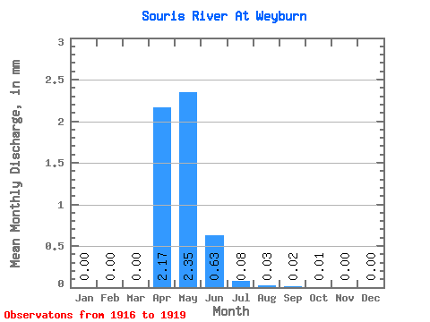
| Statistic | Jan | Feb | Mar | Apr | May | Jun | Jul | Aug | Sep | Oct | Nov | Dec | Annual |
|---|---|---|---|---|---|---|---|---|---|---|---|---|---|
| Mean | 0.00 | 0.00 | 0.00 | 0.85 | 0.92 | 0.25 | 0.03 | 0.01 | 0.01 | 0.00 | 0.00 | 0.00 | 2.22 |
| Standard Deviation | 0.00 | 0.00 | 0.00 | 1.44 | 1.15 | 0.29 | 0.04 | 0.03 | 0.01 | 0.01 | 0.00 | 0.00 | 3.13 |
| Min | 0.00 | 0.00 | 0.00 | 0.00 | 0.00 | 0.00 | 0.00 | 0.00 | 0.00 | 0.00 | 0.00 | 0.00 | 0.01 |
| Max | 0.00 | 0.00 | 0.00 | 2.51 | 2.37 | 0.53 | 0.07 | 0.05 | 0.03 | 0.01 | 0.00 | 0.00 | 4.43 |
| Coefficient of Variation | 1.73 | 1.70 | 1.25 | 1.15 | 1.18 | 2.00 | 2.00 | 1.73 | 1.41 |
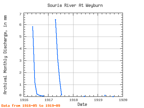
| Year | Jan | Feb | Mar | Apr | May | Jun | Jul | Aug | Sep | Oct | Nov | Dec | Annual | 1916 | 2.37 | 0.46 | 0.07 | 0.05 | 0.03 | 0.01 | 0.00 | 0.00 | 1917 | 0.00 | 0.00 | 0.00 | 2.51 | 1.31 | 0.53 | 0.05 | 0.00 | 0.00 | 0.00 | 0.00 | 0.00 | 4.43 | 1918 | 0.00 | 0.00 | 0.00 | 0.00 | 0.00 | 0.00 | 0.00 | 0.00 | 0.00 | 0.00 | 0.00 | 0.00 | 0.01 | 1919 | 0.00 | 0.00 | 0.00 | 0.03 | 0.00 | 0.00 | 0.00 | 0.00 | 0.00 |
|---|
 Return to R-Arctic Net Home Page