|
|
|||||||||||||||||
| Point ID: 5424 | Downloads | Plots | Site Data | Code: 05KB001 |
|
|
|||||||||||||||||
| Download | |
|---|---|
| Site Descriptor Information | Site Time Series Data |
| Link to all available data | |
|
|
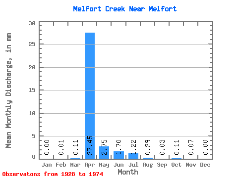
| View: | Statistics | Time Series |
| Units: | m3/s |
| Statistic | Jan | Feb | Mar | Apr | May | Jun | Jul | Aug | Sep | Oct | Nov | Dec | Annual |
|---|---|---|---|---|---|---|---|---|---|---|---|---|---|
| Mean | 0.00 | 0.01 | 0.07 | 20.01 | 2.00 | 1.24 | 0.89 | 0.21 | 0.03 | 0.09 | 0.05 | 0.00 | 10.85 |
| Standard Deviation | 0.00 | 0.01 | 0.15 | 29.84 | 1.44 | 1.09 | 0.62 | 0.32 | 0.03 | 0.12 | 0.08 | 0.00 | 9.95 |
| Min | 0.00 | 0.00 | 0.00 | 1.27 | 0.98 | 0.32 | 0.36 | 0.01 | 0.00 | 0.00 | 0.00 | 0.00 | 3.82 |
| Max | 0.00 | 0.02 | 0.30 | 64.02 | 3.02 | 2.44 | 1.57 | 0.58 | 0.06 | 0.23 | 0.14 | 0.00 | 17.88 |
| Coefficient of Variation | 1.73 | 2.00 | 1.49 | 0.72 | 0.88 | 0.70 | 1.52 | 1.04 | 1.42 | 1.62 | 0.92 |
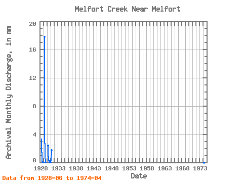
| Year | Jan | Feb | Mar | Apr | May | Jun | Jul | Aug | Sep | Oct | Nov | Dec | Annual | 1928 | 2.44 | 1.57 | 0.58 | 0.06 | 0.03 | 0.01 | 0.00 | 1929 | 0.00 | 0.00 | 0.00 | 12.99 | 3.02 | 0.96 | 0.73 | 0.04 | 0.00 | 0.00 | 0.00 | 0.00 | 17.88 | 1930 | 0.00 | 0.00 | 0.00 | 1.75 | 0.98 | 0.32 | 0.36 | 0.01 | 0.03 | 0.23 | 0.14 | 0.00 | 3.82 | 1931 | 0.00 | 0.02 | 0.30 | 1.27 | 1974 | 0.00 | 64.02 |
|---|
 Return to R-Arctic Net Home Page