|
|
|||||||||||||||||
| Point ID: 529 | Downloads | Plots | Site Data | Code: 05FA010 |
|
|
|||||||||||||||||
| Download | |
|---|---|
| Site Descriptor Information | Site Time Series Data |
| Link to all available data | |
|
|
| View: | Statistics | Time Series |
| Units: | m3/s |
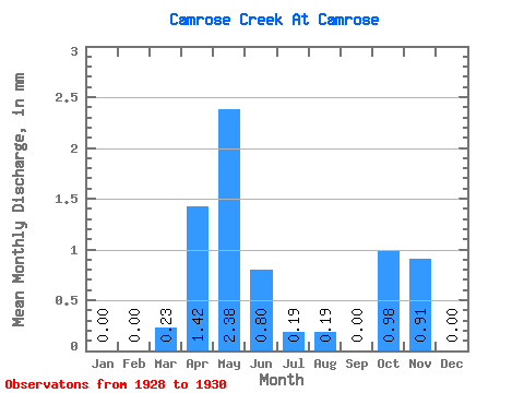
| Statistic | Jan | Feb | Mar | Apr | May | Jun | Jul | Aug | Sep | Oct | Nov | Dec | Annual |
|---|---|---|---|---|---|---|---|---|---|---|---|---|---|
| Mean | 0.00 | 0.00 | 0.03 | 0.20 | 0.34 | 0.11 | 0.03 | 0.03 | 0.00 | 0.14 | 0.13 | 0.00 | 0.84 |
| Standard Deviation | 0.00 | 0.00 | 0.03 | 0.24 | 0.58 | 0.20 | 0.04 | 0.04 | 0.00 | 0.20 | 0.00 | ||
| Min | 0.00 | 0.00 | 0.01 | 0.03 | 0.00 | 0.00 | 0.00 | 0.00 | 0.00 | 0.00 | 0.13 | 0.00 | 0.84 |
| Max | 0.00 | 0.00 | 0.05 | 0.37 | 1.01 | 0.34 | 0.08 | 0.06 | 0.01 | 0.28 | 0.13 | 0.00 | 0.84 |
| Coefficient of Variation | 0.94 | 1.19 | 1.72 | 1.73 | 1.56 | 1.41 | 1.73 | 1.41 |
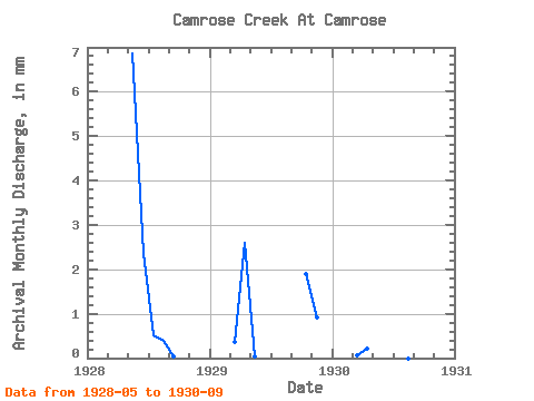
| Year | Jan | Feb | Mar | Apr | May | Jun | Jul | Aug | Sep | Oct | Nov | Dec | Annual | 1928 | 1.01 | 0.34 | 0.08 | 0.06 | 0.01 | 0.00 | 0.00 | 1929 | 0.00 | 0.00 | 0.05 | 0.37 | 0.01 | 0.00 | 0.00 | 0.00 | 0.00 | 0.28 | 0.13 | 0.00 | 0.84 | 1930 | 0.00 | 0.00 | 0.01 | 0.03 | 0.00 | 0.00 | 0.01 | 0.00 |
|---|
 Return to R-Arctic Net Home Page