|
|
|||||||||||||||||
| Point ID: 5188 | Downloads | Plots | Site Data | Code: 04NA003 |
|
|
|||||||||||||||||
| Download | |
|---|---|
| Site Descriptor Information | Site Time Series Data |
| Link to all available data | |
|
|
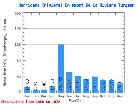
| View: | Statistics | Time Series |
| Units: | m3/s |
| Statistic | Jan | Feb | Mar | Apr | May | Jun | Jul | Aug | Sep | Oct | Nov | Dec | Annual |
|---|---|---|---|---|---|---|---|---|---|---|---|---|---|
| Mean | 14.09 | 7.83 | 6.48 | 17.73 | 120.51 | 51.84 | 42.11 | 34.98 | 40.44 | 31.87 | 32.40 | 23.11 | |
| Standard Deviation | 6.08 | 18.42 | 28.59 | 23.52 | 19.14 | 12.02 | |||||||
| Min | 14.09 | 7.83 | 6.48 | 13.01 | 99.62 | 31.62 | 24.56 | 22.92 | 26.96 | 31.87 | 32.40 | 23.11 | |
| Max | 14.09 | 7.83 | 6.48 | 24.60 | 134.44 | 72.06 | 68.83 | 57.04 | 50.03 | 31.87 | 32.40 | 23.11 | |
| Coefficient of Variation | 0.34 | 0.15 | 0.55 | 0.56 | 0.55 | 0.30 |
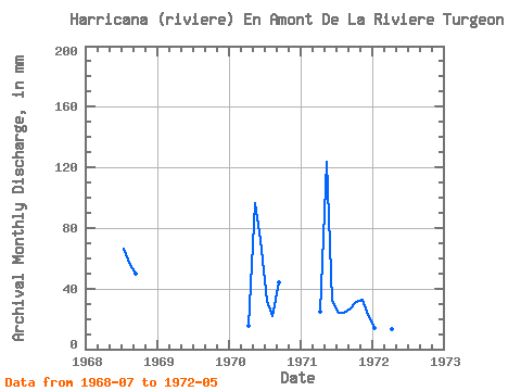
| Year | Jan | Feb | Mar | Apr | May | Jun | Jul | Aug | Sep | Oct | Nov | Dec | Annual | 1968 | 68.83 | 57.04 | 50.03 | 1970 | 15.58 | 99.62 | 72.06 | 32.94 | 22.92 | 44.32 | 1971 | 24.60 | 127.47 | 31.62 | 24.56 | 24.96 | 26.96 | 31.87 | 32.40 | 23.11 | 1972 | 14.09 | 7.83 | 6.48 | 13.01 | 134.44 |
|---|
 Return to R-Arctic Net Home Page