|
|
|||||||||||||||||
| Point ID: 5150 | Downloads | Plots | Site Data | Code: 03FC002 |
|
|
|||||||||||||||||
| Download | |
|---|---|
| Site Descriptor Information | Site Time Series Data |
| Link to all available data | |
|
|
| View: | Statistics | Time Series |
| Units: | m3/s |
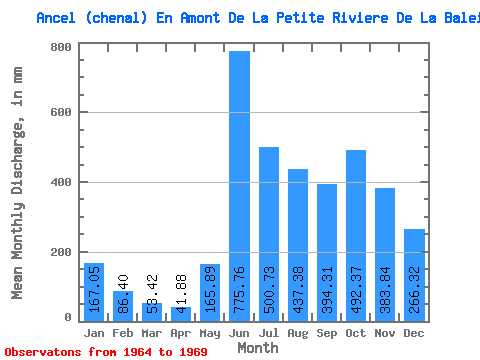
| Statistic | Jan | Feb | Mar | Apr | May | Jun | Jul | Aug | Sep | Oct | Nov | Dec | Annual |
|---|---|---|---|---|---|---|---|---|---|---|---|---|---|
| Mean | 167.02 | 87.15 | 53.41 | 41.87 | 165.86 | 775.76 | 500.65 | 437.31 | 394.31 | 492.30 | 383.84 | 266.28 | 3679.20 |
| Standard Deviation | 54.69 | 23.43 | 22.47 | 18.98 | 98.10 | 136.70 | 122.40 | 100.17 | 110.81 | 142.87 | 99.66 | 70.15 | 566.71 |
| Min | 119.09 | 59.70 | 33.05 | 20.59 | 79.96 | 621.35 | 326.68 | 309.58 | 238.98 | 290.59 | 261.04 | 193.73 | 2863.16 |
| Max | 250.71 | 115.77 | 86.42 | 61.77 | 305.79 | 954.08 | 664.75 | 528.00 | 483.47 | 674.25 | 518.40 | 353.27 | 4144.77 |
| Coefficient of Variation | 0.33 | 0.27 | 0.42 | 0.45 | 0.59 | 0.18 | 0.24 | 0.23 | 0.28 | 0.29 | 0.26 | 0.26 | 0.15 |
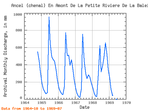
| Year | Jan | Feb | Mar | Apr | May | Jun | Jul | Aug | Sep | Oct | Nov | Dec | Annual | 1964 | 569.79 | 444.87 | 328.58 | 1965 | 193.73 | 115.77 | 86.42 | 61.77 | 79.96 | 954.08 | 664.75 | 505.21 | 463.25 | 453.93 | 338.25 | 231.71 | 4144.77 | 1966 | 136.75 | 84.62 | 66.09 | 53.31 | 153.84 | 772.09 | 524.20 | 528.00 | 391.56 | 472.92 | 356.63 | 224.12 | 3756.05 | 1967 | 119.09 | 59.70 | 33.05 | 20.59 | 123.83 | 755.54 | 461.53 | 309.58 | 238.98 | 290.59 | 261.04 | 193.73 | 2863.16 | 1968 | 134.85 | 70.26 | 36.66 | 31.80 | 305.79 | 621.35 | 326.68 | 406.45 | 483.47 | 674.25 | 518.40 | 353.27 | 3952.83 | 1969 | 250.71 | 105.39 | 44.82 | 526.10 |
|---|
 Return to R-Arctic Net Home Page