|
|
|||||||||||||||||
| Point ID: 515 | Downloads | Plots | Site Data | Code: 05EE002 |
|
|
|||||||||||||||||
| Download | |
|---|---|
| Site Descriptor Information | Site Time Series Data |
| Link to all available data | |
|
|
| View: | Statistics | Time Series |
| Units: | m3/s |
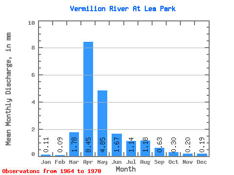
| Statistic | Jan | Feb | Mar | Apr | May | Jun | Jul | Aug | Sep | Oct | Nov | Dec | Annual |
|---|---|---|---|---|---|---|---|---|---|---|---|---|---|
| Mean | 0.05 | 0.04 | 0.81 | 3.86 | 2.21 | 0.76 | 0.52 | 0.54 | 0.29 | 0.14 | 0.09 | 0.09 | 8.82 |
| Standard Deviation | 0.04 | 0.03 | 1.58 | 3.09 | 1.46 | 0.77 | 0.61 | 0.95 | 0.48 | 0.14 | 0.10 | 0.10 | 7.21 |
| Min | 0.01 | 0.01 | 0.01 | 0.30 | 0.58 | 0.17 | 0.05 | 0.03 | 0.01 | 0.01 | 0.01 | 0.01 | 3.58 |
| Max | 0.10 | 0.08 | 3.64 | 7.08 | 4.08 | 2.29 | 1.66 | 2.45 | 1.25 | 0.41 | 0.25 | 0.26 | 19.44 |
| Coefficient of Variation | 0.81 | 0.68 | 1.95 | 0.80 | 0.66 | 1.01 | 1.17 | 1.76 | 1.66 | 1.04 | 1.06 | 1.14 | 0.82 |
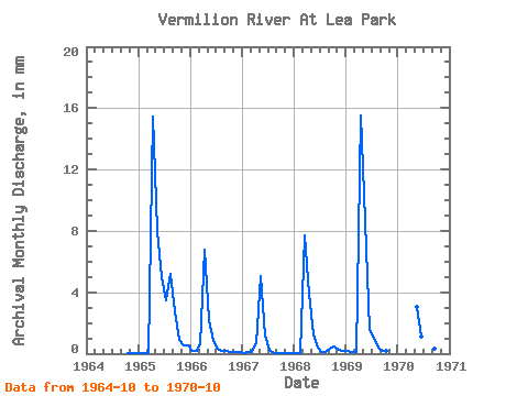
| Year | Jan | Feb | Mar | Apr | May | Jun | Jul | Aug | Sep | Oct | Nov | Dec | Annual | 1964 | 0.01 | 0.01 | 0.01 | 1965 | 0.01 | 0.01 | 0.01 | 7.05 | 3.78 | 2.29 | 1.66 | 2.45 | 1.25 | 0.41 | 0.25 | 0.26 | 19.44 | 1966 | 0.10 | 0.08 | 0.29 | 3.10 | 1.02 | 0.36 | 0.14 | 0.10 | 0.08 | 0.06 | 0.05 | 0.04 | 5.45 | 1967 | 0.03 | 0.04 | 0.06 | 0.30 | 2.40 | 0.54 | 0.13 | 0.03 | 0.01 | 0.02 | 0.03 | 0.04 | 3.58 | 1968 | 0.02 | 0.03 | 3.64 | 1.78 | 0.58 | 0.17 | 0.05 | 0.05 | 0.15 | 0.21 | 0.10 | 0.08 | 6.81 | 1969 | 0.09 | 0.06 | 0.07 | 7.08 | 4.08 | 0.71 | 0.44 | 0.20 | 0.07 | 0.09 | 1970 | 1.43 | 0.51 | 0.73 | 0.41 | 0.15 | 0.14 |
|---|
 Return to R-Arctic Net Home Page