|
|
|||||||||||||||||
| Point ID: 5116 | Downloads | Plots | Site Data | Other Close Sites | Code: 03DC001 |
|
|
|||||||||||||||||
| Download | |
|---|---|
| Site Descriptor Information | Site Time Series Data |
| Link to all available data | |
|
|
| View: | Statistics | Time Series |
| Units: | m3/s |
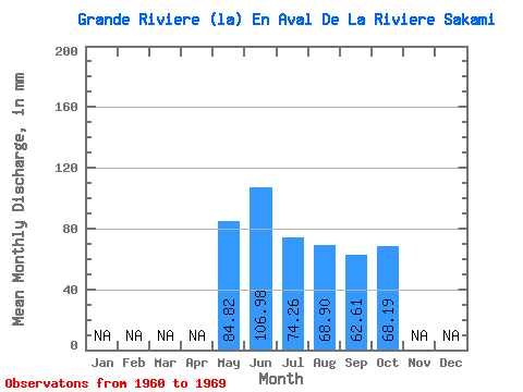
| Statistic | Jan | Feb | Mar | Apr | May | Jun | Jul | Aug | Sep | Oct | Nov | Dec | Annual |
|---|---|---|---|---|---|---|---|---|---|---|---|---|---|
| Mean | 84.81 | 106.98 | 74.25 | 68.89 | 62.61 | 68.19 | |||||||
| Standard Deviation | 17.49 | 22.68 | 25.79 | 26.05 | 21.39 | 21.07 | |||||||
| Min | 65.05 | 72.06 | 53.13 | 39.39 | 36.73 | 39.03 | |||||||
| Max | 98.30 | 129.78 | 121.07 | 106.25 | 95.14 | 86.74 | |||||||
| Coefficient of Variation | 0.21 | 0.21 | 0.35 | 0.38 | 0.34 | 0.31 |
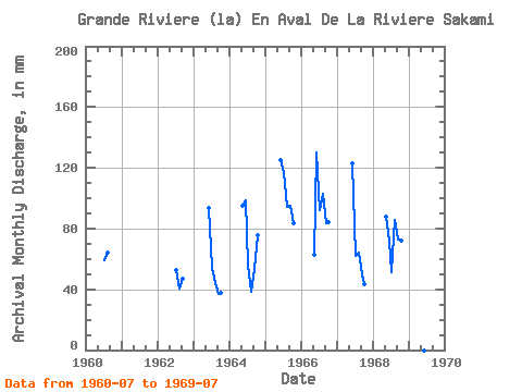
| Year | Jan | Feb | Mar | Apr | May | Jun | Jul | Aug | Sep | Oct | Nov | Dec | Annual | 1960 | 61.44 | 66.14 | 1962 | 54.57 | 41.92 | 47.22 | 1963 | 93.75 | 55.66 | 45.54 | 36.73 | 39.03 | 1964 | 98.30 | 98.29 | 57.46 | 39.39 | 53.52 | 78.42 | 1965 | 125.23 | 121.07 | 97.58 | 95.14 | 86.01 | 1966 | 65.05 | 129.78 | 95.41 | 106.25 | 83.25 | 86.74 | 1967 | 122.78 | 64.33 | 66.14 | 49.67 | 44.45 | 1968 | 91.07 | 72.06 | 53.13 | 88.18 | 72.76 | 74.45 | 1969 | 105.17 |
|---|
| Other Close Sites | ||||||
|---|---|---|---|---|---|---|
| PointID | Latitude | Longitude | Drainage Area | Source | Name | |
| 5113 | "KANAAUPSCOW (RIVIERE) EN AMONT DU RUISSEAU POUTRE" | 53.75 | -893069 | Hydat | ||
| 5114 | "KANAAUPSCOW (RIVIERE) EN AMONT DU RUISSEAU POUTRE-2" | 53.75 | -893743 | Hydat | ||
| 5126 | "SAKAMI (RIVIERE) PRES DE LA GRANDE RIVIERE" | 53.65 | -918413 | Hydat | ||
 Return to R-Arctic Net Home Page