|
|
|||||||||||||||||
| Point ID: 5 | Downloads | Plots | Site Data | Code: 05AA005 |
|
|
|||||||||||||||||
| Download | |
|---|---|
| Site Descriptor Information | Site Time Series Data |
| Link to all available data | |

|
|
| View: | Statistics | Time Series |
| Units: | m3/s |
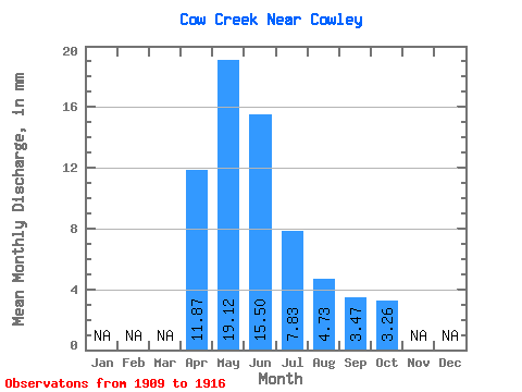
| Statistic | Jan | Feb | Mar | Apr | May | Jun | Jul | Aug | Sep | Oct | Nov | Dec | Annual |
|---|---|---|---|---|---|---|---|---|---|---|---|---|---|
| Mean | 11.87 | 19.11 | 15.51 | 7.81 | 4.72 | 3.46 | 3.27 | ||||||
| Standard Deviation | 3.63 | 7.19 | 10.76 | 7.04 | 3.53 | 2.79 | 1.51 | ||||||
| Min | 8.05 | 10.96 | 3.35 | 0.91 | 0.33 | 0.60 | 0.95 | ||||||
| Max | 15.28 | 29.03 | 33.15 | 19.15 | 11.48 | 9.47 | 5.94 | ||||||
| Coefficient of Variation | 0.31 | 0.38 | 0.69 | 0.90 | 0.75 | 0.81 | 0.46 |
| Year | Jan | Feb | Mar | Apr | May | Jun | Jul | Aug | Sep | Oct | Nov | Dec | Annual | 1909 | 11.48 | 4.11 | 3.26 | 1910 | 3.35 | 0.91 | 0.33 | 0.60 | 0.95 | 1911 | 25.74 | 13.45 | 2.45 | 6.85 | 9.47 | 5.94 | 1912 | 10.96 | 7.92 | 7.63 | 4.50 | 3.00 | 3.29 | 1913 | 18.59 | 15.22 | 4.60 | 1.99 | 1.29 | 1.60 | 1914 | 15.28 | 12.14 | 8.68 | 3.95 | 1.76 | 1.58 | 3.59 | 1915 | 8.05 | 29.03 | 33.15 | 19.15 | 5.74 | 3.16 | 3.98 | 1916 | 12.28 | 18.17 | 26.78 | 16.02 | 5.09 | 4.48 | 3.59 |
|---|
 Return to R-Arctic Net Home Page