|
|
|||||||||||||||||
| Point ID: 461 | Downloads | Plots | Site Data | Code: 05DC004 |
|
|
|||||||||||||||||
| Download | |
|---|---|
| Site Descriptor Information | Site Time Series Data |
| Link to all available data | |
|
|
| View: | Statistics | Time Series |
| Units: | m3/s |
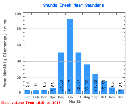
| Statistic | Jan | Feb | Mar | Apr | May | Jun | Jul | Aug | Sep | Oct | Nov | Dec | Annual |
|---|---|---|---|---|---|---|---|---|---|---|---|---|---|
| Mean | 4.38 | 4.14 | 4.86 | 6.86 | 50.58 | 91.47 | 50.86 | 35.91 | 24.30 | 15.84 | 7.65 | 5.33 | 273.23 |
| Standard Deviation | 1.05 | 0.56 | 1.05 | 0.39 | 33.39 | 58.19 | 23.62 | 33.52 | 18.24 | 6.06 | 1.79 | 0.47 | 48.91 |
| Min | 3.17 | 3.69 | 3.65 | 6.58 | 26.97 | 53.40 | 34.16 | 12.21 | 12.82 | 9.75 | 6.14 | 4.98 | 238.64 |
| Max | 5.03 | 4.77 | 5.50 | 7.13 | 74.19 | 158.45 | 67.56 | 59.62 | 45.34 | 21.86 | 9.62 | 5.87 | 307.81 |
| Coefficient of Variation | 0.24 | 0.14 | 0.21 | 0.06 | 0.66 | 0.64 | 0.46 | 0.93 | 0.75 | 0.38 | 0.23 | 0.09 | 0.18 |
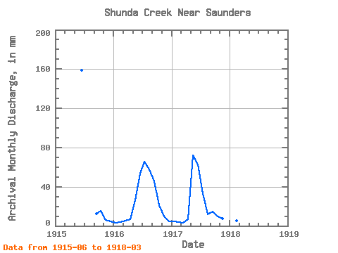
| Year | Jan | Feb | Mar | Apr | May | Jun | Jul | Aug | Sep | Oct | Nov | Dec | Annual | 1915 | 158.45 | 12.82 | 15.90 | 6.14 | 4.98 | 1916 | 3.17 | 3.98 | 5.43 | 7.13 | 26.97 | 53.40 | 67.56 | 59.62 | 45.34 | 21.86 | 9.62 | 5.14 | 307.81 | 1917 | 5.03 | 3.69 | 3.65 | 6.58 | 74.19 | 62.56 | 34.16 | 12.21 | 14.75 | 9.75 | 7.19 | 5.87 | 238.64 | 1918 | 4.96 | 4.77 | 5.50 |
|---|
 Return to R-Arctic Net Home Page